Minnamurra, Bombo & Kiama 06-09-2020
This map was created using GPS Visualizer's do-it-yourself geographic utilities.
Please wait while the map data loads...
Route: Minnamurra, Minnamurra Lookout, Johnson Street, Jones Beach, Cathedral Rocks, Cliff Drive, The Boneyard, Bombo Headland, Bombo Quarry, Bombo Beach, Gipps St, Kiama Harbour, Kiama Lighthouse, Blowhole Point, Kiama
Date: 06/09/2020
From: Minnamurra
Parking: N/A
Start Point: Minnamurra
Finish Point: Kiama
Region: Shellharbour
Route length: 8.2 miles (13.2km)
Time taken: 04:15
Average speed: 2.5mph
Ascent: 307m
Descent: 310m
Points of Interest: Minnamurra, Jones Beach, Cathedral Rocks, Bombo, Kiama
We've been neglecting the areas south of Sydney in favour of the Blue Mountains and camping trips further afield. Now that the weather is becoming more spring-like, we decided to venture southwards once again to the coastal stretch between Minnamurra and Kiama.
You may recall our visit to the Minnamurra Rainforest in those long-forgotten days before Covid - this hike begins where the Minnamurra river meets the sea and extends south to the popular resort town of Kiama with its famed lighthouse and blowhole. The local train line provides an easy means of transport for this one-way hike. This is the first section of the Kiama Coast Walk.
We started from Minnamurra village, parking close to the small platform that makes up the train station. Minnamurra means 'plenty of fish' in the local Aboriginal dialect of the Dharawal people and, once we reached the beach, we could see why. The river estuary is beautiful and looks ideal for a mid-summer swim or, some fishing.
 |
Minnamurra River
|
 |
| Stack Island |
The Coast Walk path climbs a headland to Minnamurra Point which has a sweeping view of the estuary, looking across Boyds Beach and the dramatic volcanic sea stack known as Stack Island. This is a very different territory from the sandstone-dominated geology of Sydney and the Blue Mountains. The path continues south to a whale watching platform (winter is the peak season for spotting migrating Humpback whales) and then threads through a section of suburbia to find Jones Beach.
 |
The sparkling Minnamurra River estuary
|
 |
Cliffs overlooking Stack Island
|
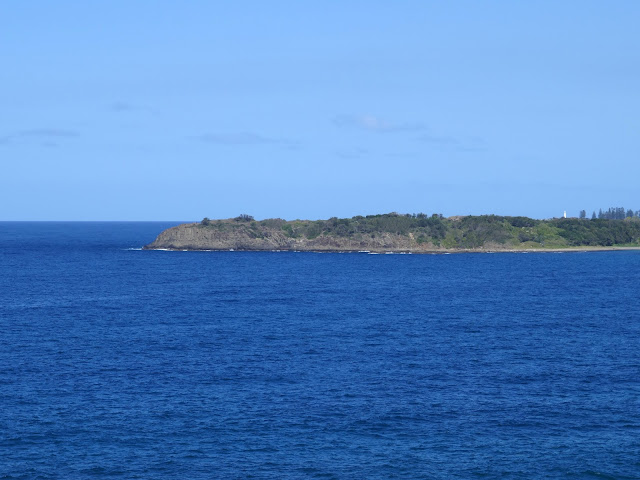 |
Bombo Headland
|
 |
Jones Beach
|
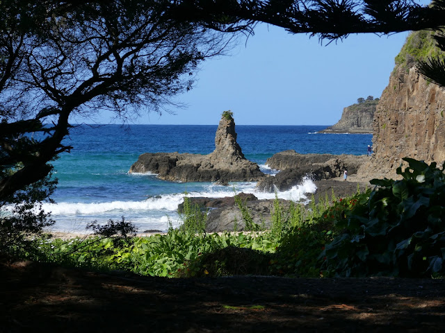
The long stretch of sand is popular with surfers, particularly at Kiama Downs where the local lifesaving club is located. We followed the length of the beach to its southern end where you will find Cathedral Rocks, which is a must-see along the route.
 |
Jones Beach
|
 |
Jones Beach
|
Accessed along a rock shelf, Cathedral Rocks are a series of basalt sea stacks arranged below the cliffs. One, in particular, resembles a large building, hence the name. Professional photographers flock to the area for obvious reasons and can do it far more justice than I ever could. There is also a small sea cave to investigate, hidden just around the corner of the first cliff. |
Approaching Cathedral Rocks
|
 |
Cathedral Rocks
|
 |
Cathedral Rocks
|
 |
This stack, in particular, resembles a large building
|
 |
The rock shelf at Cathedral Rocks
|
 |
Cathedral Rocks
|
 |
The sea cave at Cathedral Rocks
|
 |
Sara heads back to the beach
|
We backtracked along the beach a short distance to a path that runs along the back of some fine-looking properties until we reached a car park around halfway along Jones Beach (it may be possible to pick a way around Cathedral Rocks along the cliffs but we weren't in the mood to find out). From the car park, we followed North Kiama Drive south as it rises over a low hill to Cliff Drive before Cliff Drive descends to The Boneyard.
 |
| Cathedral Rocks |
 |
Sara follows the path alongside Jones Beach
|
 |
Looking towards The Boneyard
|
 |
Overlooking Cathedral Rocks
|
 |
The Boneyard Beach
|
The sheltered pebble beach gets its name from a heavy reef break called Boneyards, located just off the shore, rather than anything more sinister. The path follows the beach and the shoreline briefly before venturing into the bush on the Bombo Headland, home to some unique geological formations.
 |
| The Boneyard Beach |
 |
Cathedral Rocks
|
 |
The Boneyard Beach
|
As I mentioned earlier, the coastline here is volcanic basalt, which forms vertical columns much like those found at the Giants Causeway in Northern Ireland. The Bombo Headland, however, used to be a working quarry and, while largely artificial, has left hundreds of tall, vertical basalt columns remaining. It is now a heritage-listed geological site. 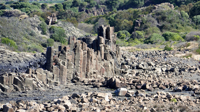 |
Bombo Quarry
|
 |
Overlooking Bombo Quarry from the headland
|
 |
Bombo Quarry
|
 |
Bombo Quarry
|
The headland provides a good view over the quarry and following the path further allows you to detour into the quarry if you desire. Here you can get up close to the hexagonal columns and it provides endless opportunities for those sporting a camera.
 |
Bombo Quarry
|
 |
Bombo Quarry
|
 |
Bombo Quarry
|
 |
Bombo Quarry
|
We left the quarry and made our way south to Bombo Beach, another long strip of golden sand served by its very own train station. We followed the beach to the southern end where we crossed Spring Creek, heading beneath the railway to Hothersal Street. This led us to Gripps Street which ultimately makes its way into Kiama.
 |
Bombo Beach
|
 |
Bombo Beach
|
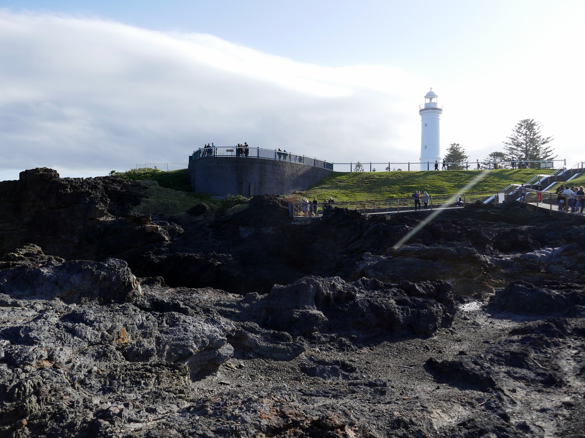
Kiama is a beautiful seaside town, best known for its lighthouse and blowholes. Located on Blowhole Point, the Kiama Lighthouse is hard to miss. It was established in 1887, 10 years after the creation of the man-made Kiama Harbour
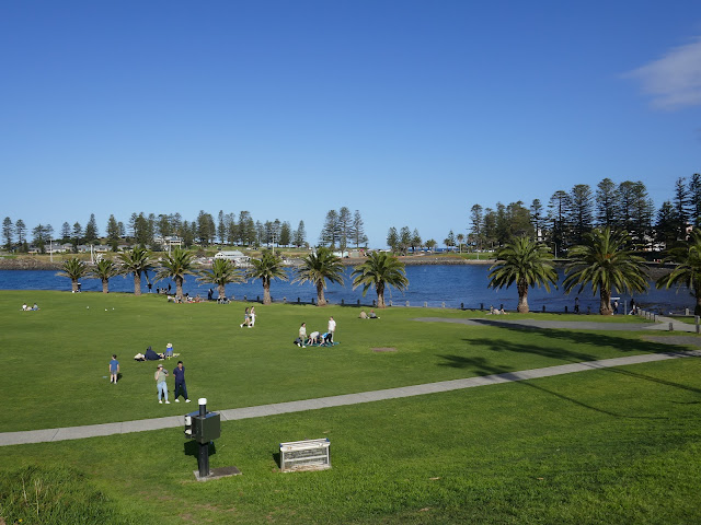 |
Kiama Harbour
|
 |
Kiama Harbour
|
 |
| Kiama Lighthouse |
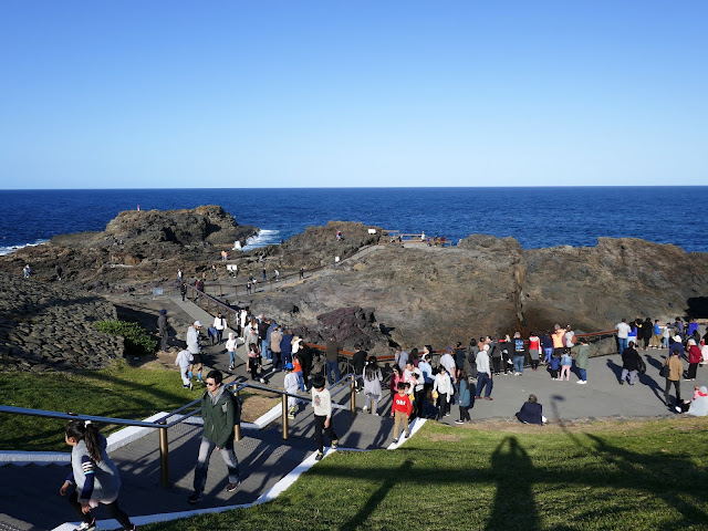
Sitting just beneath the lighthouse is the Kiama Blowhole, a natural cavity in the rugged cliffs that blasts seawater 20 metres or more into the air. Today, it was a little benign due to the small waves but we did see one or two spurts while we were hanging around waiting for the time to head to the train station.
 |
Blowhole Point
|
 |
Kiama Blowhole
|
 |
Blowhole Point
|
It wasn't long before we were back in Minnmurra retrieving the car from our starting point in the village. I thoroughly enjoyed this walk and, considering it's the first third of a much longer hike, I'm keen to revisit it again in the future.


No comments :
Post a Comment