Lockley's Pylon & Du Faur Head 12-09-2020
This map was created using GPS Visualizer's do-it-yourself geographic utilities.
Please wait while the map data loads...
Route: Lockleys Pylon Trailhead, The Pinnacles, Mount Stead, Lockleys Pylon, Du Faur Head, Lockleys Pylon Trailhead
Date: 12/09/2020
From: Mount Hay Road - Lockley's Pylon Trailhead
Parking: Mount Hay Road
Start Point: Lockley's Pylon Trailhead
Finish Point: Lockley's Pylon Trailhead
Region: Blue Mountains
Route length: 5.0 miles (8.0km)
Time taken: 02:15
Average speed: 2.4mph
Ascent: 323m
Descent: 319m
Points of Interest: Lockley's Pylon, Du Faur Head
Having explored many of the popular areas of the Blue Mountains, it was time to venture a little further afield in search of some Australian wilderness. One such place is the south rim of the Grose Valley, north of the village of Leura. It is only accessible along a 15km unsealed road which is known to be a tricky proposition for 2WD drive cars like ours. However, after a bit of research, I discovered it had recently been re-graded meaning that it was likely to be in its best condition for many years. Time to test it out in our Golf.
The road, Mount Hay Road, provides access to two separate walking tracks, each consisting of a 6km or so return trip to the canyon rim. The plan was to hike one in the morning then move the car and hike the other in the afternoon. First up was Lockley's Pylon.
Mount Hay Road is only suitable for 2WD cars in fine, dry conditions. There are a couple of steep hills which would become very slippery in the wet. Otherwise, only a few rogue potholes caused any concerns on the 20min drive from Leura. It leads to the trailhead for Lockley's Pylon, a prominent rock dome that promises sweeping views of the Grose Valley
A path leaves the trailhead, leading north into the bush. It passes beneath a tall outcrop of rock called the Pinnacles for reasons that are obvious. The path follows parallel to Fortress Creek, with views across the valley to Fortress Ridge before it delves into the taller Eucalyptus woods.
 |
The Lockley's Pylon track
|
 |
Looking out over the Australian bush
|
 |
The valley of Fortress Creek
|
 |
| Passing beneath The Pinnacles |
 |
Fortress Creek
|
 |
Fire-damaged Eucalyptus trees
|
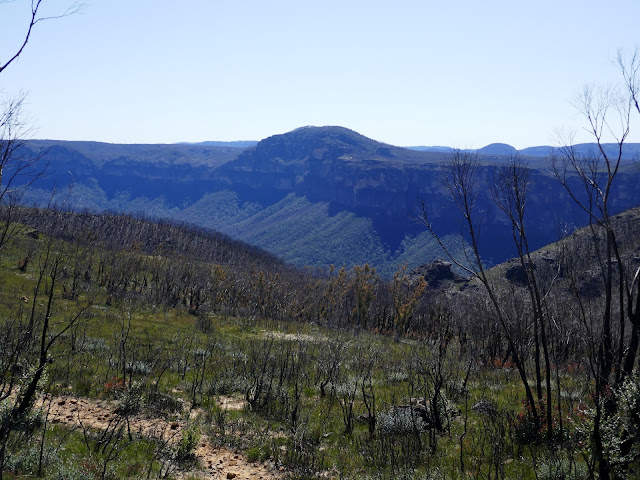
The path emerges briefly on the other side of a low hill with a lookout over the Fortress Creek valley before venturing back into the woods again. Once out of the trees once more, the view opens up on the slopes of Mount Stead, with a clear view of Lockley's Pylon and the surrounding sandstone cliffs. The path crosses the top of an unnamed creek before reaching the base of the domed hill. A set of steps leads to the top of the dome or, a side path branches off to the west towards the edge of the cliffs - I followed the latter. |
| Mount Stead lies ahead, a low hill on the Lockley Pylon Track |
 |
| More fire damaged woodland on Mount Stead |
 |
A distant Mount Wilson
|
 |
The trees open up to a grassy expanse near Lockley's Pylon
|
 |
Lockley's Pylon
|
The western path leads directly to the unfenced cliff edge and has a sensational 180-degree view of the Grose Valley. Fortress Creek Falls is well seen from this vantage point while the more famous Govetts Leap can be seen in the distance. The vertical cliffs also have a precipitous view directly down into the valley.
 |
| First view of the upper Grose Valley |
 |
Fortress Ridge ends abruptly at the Grose Valley
|
 |
Fortress Creek falls
|
 |
The Grose Valley - looking across to Clarke Head
|
 |
Grose Valley panorama
|
 |
| Fortress Creek and the head of the Grose Valley |
 |
Beneath Lockley's Pylon
|
 |
The Grose Valley
|
After taking in the view, I backtracked to the top of Lockley's Pylon which is topped by a cairn and a small sign. The view now opens up to the east, looking over Du Faur Head and across the forested valley to Mount Banks.
 |
| Lockley's Pylon summit |
 |
| The view east along the Grose Valley with Mount Hay to the right |
 |
Looking across Du Faur Head towards Mount Banks
|
The aforementioned Du Faur Head is located to the northeast of Lockley's Pylon, requiring a short descent to reach it. The prominent outcrop (named after Eccleston Du Faur, who was instrumental in the creation of Ku-ring-gai Chase National Park) guards the Shortridge Pass which descends a steep cleft in the cliffs to the Blue Gum forest below. At the time of writing, it is still off-limits while the forest recovers from the 19-20 bushfires.
 |
Heading to Du Faur Head
|
 |
The top of the Shortridge Pass
|
 |
Lockley's Pylon
|
 |
Looking down into the fire-damaged Grose Valley
|
Views from Du Faur Head get you up close and personal with the sandstone cliffs as well as an impressive view east along the lower Grose Valley towards Butterbox Point and Mount Hay (the subject of part two of this outing). I spent a few minutes wandering around the cliff tops before starting back to the car. |
Looking towards Butterbox Point and Mount Hay
|
 |
The Grose Valley - looking north
|
 |
The Grose Valley - looking east
|
The route back is simply the Lockley's Pylon track in reverse though you can skirt around the base of the hill rather than going over the top. While the overall views remain the same, The Pinnacles are more impressive when you approach them from the north. After a short while, I was back at the car, contemplating the drive to Butterbox Point. You can read how I got on here.  |
| Heading back towards Lockley's Pylon |
 |
The path towards Mount Stead
|
 |
Fortress Creek
|


Panorama is great;)
ReplyDelete