Showing posts with label nsw national park. Show all posts

Saturday, 14 January 2023

The Overcliff-Undercliff Track - Wentworth Falls - Blue Mountains National Park

The Overcliff-Undercliff Track 14-01-2023

This map was created using GPS Visualizer's do-it-yourself geographic utilities.

Please wait while the map data loads...

Route: Wilson Street, Wentworth Falls Picnic Area, Short Cut Track, Lyrebird Lookout, Overcliff Track, Breakfast Point Lookout, Den Fenella, Undercliff Track, Fletchers Lookout, Wentworth Falls Track, National Pass, Weeping Rock, Wentworth Falls Track

Date: 14/01/2023
From: Wentworth Falls Picnic Area


Parking: Wentworth Falls Picnic Area
Start PointWentworth Falls Picnic Area
Finish Point: Wentworth Falls Picnic Area
Region: Blue Mountains

Route length: 4.9km
Time taken: 02:30
Average speed: 3.5km/h
Ascent: 199m
Descent: 195m

Points of Interest: Breakfast Point Lookout, Fletchers Lookout, Wentworth Falls, National Pass, Weeping Rock

Wentworth Falls is one of the most popular areas of the Blue Mountains but it has suffered in recent years after severe weather and landslides damaged several tracks, including National Pass and Wentworth Pass. Both are currently closed and unlikely to reopen. 

Despite this, there are still some amazing routes around the waterfall, and the combined Overcliff and Undercliff tracks are probably one of the best. At just under 5 km, it packs a lot into a short space and is perfect for a morning or afternoon excursion (or for visiting parents, as was the case today).

We began our hike from the Wentworth Falls Picnic Area, a large space home to a car park, toilets, public barbecues and large lawns — ideal for lazy Sundays. On popular days, you may struggle to find a parking spot at the picnic area, though parking along Wilson Street seems to be an acceptable alternative.
The Wentworth Falls entrance to the National Park
At the western end of the picnic area is the Short Cut Track, an aptly named path that provides a shortcut to the Conservation Hut and the beginning of the Valley of the Waters. The hut was first opened in 1963 as a meeting place for the local conservation movement, hence the name. However, since 1993, Conservation Hut has operated as a café.
The Short Cut Track
The flowering Mountain Devil
Lyrebird Lookout
Conservation Hut marks the western end of the Overcliff Track, which starts close to the Queen Victoria Lookout. The lookout is perched above the Valley of the Waters, overlooking a narrow section of the valley. The views can be made more dramatic by the mists which often frequent the area on drizzly days.
Inspiration Point as seen from Lyrebird Lookout
The Overcliff Track weaves a beautiful route along the top of the cliffs above the Jamison Valley and has some wonderful views along the way. The track passes Lyrebird Lookout and then follows a large rock wall to Breakfast Point, with its low stone wall and great views across the Jamison Valley.
Inspiration Point
The Overcliff Track
Valley of the Waters
The Overcliff Track
Jamison Valley
Inspiration Point and Sublime Point
Shortly after Breakfast Point is Den Fenella where Den Fenella Creek breaches the cliffs. An out-and-back track will take you through the wet, misty gorge to a lookout, however, the gorge itself is the real highlight. It is worth following the path down the set of steps to the bridge before retracing your route.
Den Fenella
Den Fenella
At Den Fenella, the Overcliff Track becomes the Undercliff Track, named as it now forges a route beneath the overhanging cliffs of the Kedumba Walls. There are two lookouts around the halfway mark; Eagles Nest and Princes Rock. Both have excellent views of Wentworth Falls, however, Eagles Nest is currently closed due to a landslip.
Kedumba Walls
Wentworth Falls
Wentworth Falls
After the lookouts is an interesting section of the Undercliff Track that passes beneath some low overhangs before it emerges at Fletchers Lookout. Fletchers Lookout has a good view of the top of Wentworth Falls but the majority of the waterfall is hidden.
The Undercliff Track
Hikers at the top of the Grand Stairway
Wentworth Falls seen from Fletchers Lookout
Fletchers Lookout
A visit to Wentworth Falls wouldn't be complete without visiting one of the area's most photographed features - the top of the Grand Stairway. This is easily reached from Fletchers Lookout by continuing downhill to the Queen's Cascades where Jamison Creek falls over a small cascade before reaching Wentworth Falls. Stone blocks let you cross the creek above Wentworth Falls.
The top of Wentworth Falls
Queens Cascade
After crossing the falls, you will find the dramatic beginning of the National Pass and the Grand Stairway. The stairway is a very memorable section of the pass and is reported to be 'the tallest outdoor staircase in Australia'. It was built in the early 1900s by hand (and dynamite) by a team nicknamed 'the Irish Brigade' for the cost of o£430. Today, the Grand Stairway is well-maintained and provides walkers access to the valley below Wentworth Falls.
Heading along the National Pass
National Pass above Wentworth Falls
National Pass
The great cove of the lower half of Wentworth Falls
Wentworth Falls
Wentworth Falls
It's not too far from National Pass back to the picnic area but there is the opportunity to make a short diversion to Weeping Rock, a pretty waterfall that is well worth a visit. Following that there is a modest climb along the Wentworth Falls Track back towards the picnic area.
Weeping Rock
Weeping Rock
Jamison Creek
Wentworth Falls Lookout

Thursday, 22 December 2022

The Leura Cascades Round - Blue Mountains National Park

Leura Cascades 22-12-2022

This map was created using GPS Visualizer's do-it-yourself geographic utilities.

Please wait while the map data loads...

Route: Solitary Restaurant, Fossil Rock, Copelands Lookout, Prince Henry Cliff Walk, Bridal Veil Lookout, Leura Cascades Round, Leura Cascades, Upper Leura Cascades, Leura Cascades Picnic Area, Cliff Drive, Solitary Restaurant

Date: 22/12/2022
From: Solitary Restaurant


Parking: Solitary Restaurant
Start PointKiah Lookout
Finish Point: Leura Cascades Picnic Area
Region: Blue Mountains

Route length: 2.2km
Time taken: 00:50
Average speed: 3.8km/h
Ascent: 134m
Descent: 126m

Points of Interest: Bridal Veil Falls, Leura Cascades

The Leura Cascades Round is a Blue Mountains classic. It is one of the most beautiful short walks in the Blue Mountains, is well-maintained and has some stunning views along the way. It's also a good one for families as the climbs are short and not too steep. There are a couple of circuits you can complete in this area and this is one of the longer ones, visiting Copelands Lookout and Bridal Veil Lookout in addition to the cascades. All of that in under 3km.

I began this hike from the old Solitary Restaurant, located along Cliff Drive in Leura. I say old as the restaurant is currently closed awaiting renovations and looks a little worse for wear but that does mean there is a large, free car park you can use as well as ample parking along the roads nearby.

Opposite Solitary Restaurant is the Prince Henry Cliff Walk, the famed track that begins at Scenic World a few kilometres to the west. The Prince Henry Track is one of the best hikes in the Blue Mountains as it passes some of the most famous sights such as Katoomba Falls and the Three Sisters. You can access the track from the road opposite the restaurant where a set of steps lead down to Fossil Rock.

The fenced lookout at Fossil Rock has great views along the Jamison Valley, over Mount Solitary, and along the far end of Kings Tableland. It is only a short diversion from the main Prince Henry Track and worth the visit.
The fenced lookout at Fossil Rock
The cliffs of Sublime Point
Another longer, but worthwhile diversion is to Copelands Lookout. It's a 500m round trip but the lookout is often quiet and is a great viewing point surrounded by a low, sandstone wall. The lookout provides fantastic views over the Jamison Valley.
Heading for Copelands Lookout
Copelands Lookout Track
Copelands Lookout
Mount Solitary and the cliffs of Sublime Point
Mount Solitary
After visiting these two lookouts I made my way to Bridal Veil Lookout which is a personal favourite of mine. The lookout has a perilous view down to Bridal Veil Falls and across the expanse of Leura Forest. If you arrive at the right time of the day, you'll see rainbows form in the spray of the falls which is a magical sight. The lookout benefits from a brand new metal fence, part of a series of ugrades the National Park Service is undertaking across the Blue Mountains.
Bridal Veil Lookout — complete with brand-new fence
The view of the waterfall from the lookout
Bridal Veil Falls
With the excitement of the lookouts out of the way, it was time to get stuck into the Leura Cascades round proper by first descending into the lush rainforest that surrounds the creeks. The formed trail uses steps and a series of stone blocks to snake its way downhill, through some shallow caves, towards the top of Bridal Veil Falls.
Steps on the Prince Henry Cliff Walk
Stone blocks cross some wetter sections of the Leura Cascades Round
Leura Falls Creek has created this enormous gap in the cliffs
Above Bridal Veil Falls
The top of the waterfall is actually the bottom of the Leura Cascades. From the top of the falls, the path heads into a dark dell where the water swirls beneath a large overhang of sandstone before climbing alongside the tumbling waters of Leura Falls Creek - the famed Leura Cascades.
Bridal Veil Falls
Leura Falls Creek
Entering the bottom of Leura Cascades
The footbridge is currently closed due to flood damage
The climb alongside the creek is fairly gentle, making use of some nicely graded steps. At the top of the steps, the path crosses the creek and heads to a lookout below Chelmsford Bridge, an elegant un-reinforced concrete road bridge, the last of its type ever constructed in NSW.
Leura Cascades
Leura Cascades
Leura Cascades seen from the path
The climb alongside the creek is very gentle
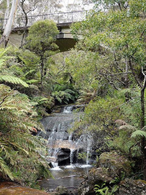
The upper cascades beneath Chelmsford Bridge
The bridge is next to the Leura Cascades picnic area, which occupies the former site of the Katoomba Baths. The Katoomba Municipal Baths were a popular swimming spot back in the 1920s up until the 1970s before the land was filled to create the picnic area.
A photo of the old baths - Chelmsford Bridge can clearly be seen in the background
The picnic area as it exists today
A new accessible path has been built to link the picnic area with Cliff Drive, the scenic link between Leura and Katoomba. At the time of writing Cliff Drive is closed to vehicles due to damage caused by the 2020 floods and is not expected to reopen until late 2023. That said, it is open to pedestrians and provides the means of completing this loop at the Solitary Restaurant.