The Grand Canyon & Cliff Top Track 25-04-2023
This map was created using GPS Visualizer's do-it-yourself geographic utilities.
Please wait while the map data loads...
Route: Cross Street, Braeside Road, Govetts Leap Brook, James Road, Evans Lookout Road, Grand Canyon Track, Neates Glen, Greaves Creek, Grand Canyon Track, Evans Lookout, Cliff Top Track, Hayward Gully, Barrow Lookout, Braeside Walk, Braeside Road
Date: 25/04/2023
From: Neates Glen
Parking: Cross Street
Start Point: Neates Glen
Finish Point: Braeside Road
Region: Blue Mountains National Park
Route length: 12.1 km
Time taken: 03:05
Average speed: 4.6 km/h
Ascent: 475m
Descent: 476m
Points of Interest: Grand Canyon, Evans Lookout, Barrow Lookout
Starting at Evans Lookout, the Grand Canyon Track is one of the most dramatic and popular circuits in the Blue Mountains. While not as grand as the Grand Canyon itself, the sheer sandstone cliffs of Greaves Creek are spectacular in their own right. Evans Lookout can be found near Blackheath, one of the small towns that line the high plateau which forms the popular tourist areas of the Blue Mountains, including Katoomba and the Three Sisters.
There is no correct direction to hike the Grand Canyon Track, both circuits involve descending into the canyon and climbing back out again. However, an anti-clockwise direction means the steeper section is done in descent and the finale at Evans Lookout is saved for the end - this is the direction I often opt for. While short, the Grand Canyon is arguably one of the best hikes in the Blue Mountains, and this particular version tags on the magnificent Cliff Top Track and Barrow Lookout.
 |
| I began the day hiking along Braeside Road to reach the start of the Grand Canyon Track |
 |
| Govetts Leap Brook |
After leaving the car on the streets of Blackheath and making my way to Evans Lookout Road, I began my descent from the Neates Glen parking area, following a zigzagging path that winds into the rainforest, passing towering ferns and dramatic overhanging rocks. It's not long before you encounter the creeks of Neates Glen (which gives its name to the parking area) which tumbles down a series of pretty cascades.
 |
| Starting the descent through Neates Glen |
 |
| The Grand Canyon Track descending into Neates Glen |
 |
| There are several small waterfalls |
 |
| Neates Glen |
 |
| Neates Glen |
 |
| Neates Glen |
The path descends further, passing some superb views of the canyon as you approached the floor of the valley. A final set of wooden steps takes you to the banks of Greaves Creek at the Rotunda, an open area where the cliff has been carved into a dramatic overhang that shelters Greaves Creek.
 |
| After emerging from Neates Glen, there are some open views of the canyon |
 |
| The Grand Canyon |
 |
| The Grand Canyon Track |
 |
| The final steps down to Greaves Creek |
 |
| The Rotunda at Greaves Creek |
It is the power of Greaves Creek that has caved a winding route through the sandstone of the Blue Mountains en route to Govetts Creek before ultimately flowing to the Grose River and the mighty Nepean. It is the erosive power of the creek which forms the huge cliffs of the Grand Canyon. The Grand Canyon Track continues its journey alongside the creek, following it as it flows downstream.
You'll shortly reach an open area surrounded by trees, ferns and plentiful running water. After squeezing through a dark tunnel, the path opens into another large area surrounded by huge boulders and a cascading waterfall. The path passes behind the waterfall (if it's flowing) and continues on its way. This area is always made more atmospheric by some light rain or mist.
 |
| At one stage, the path heads through a short, dark tunnel |
 |
| The small cascade at the end of the tunnel |
 |
| While pretty, the waterfall doesn't appear to have a name |
 |
| The path makes its way behind the falls |
 |
| Greaves Creek |
 |
| The Grand Canyon Track |
 |
| A wooden bridge crosses a deep ravine |
 |
| The Grand Canyon |
 |
| Grand Canyon Track |
 |
| Following the steps down towards Greaves Creek once again |
After negotiating the slot canyon and another descent, you'll reach Greaves Creek once again, where it emerges from the slot canyon and enters the most impressive part of the Grand Canyon. The track, still following the course of the river, crosses the stream numerous times as it passes through a dramatic section of the canyon. If there has been a lot of rain, some creek crossings may become flooded.
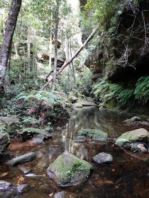 |
| Greaves Creek |
 |
| The Grand Canyon |
 |
| The Grand Canyon |
 |
| The Grand Canyon |
 |
| The path through the canyon is artfully constructed |
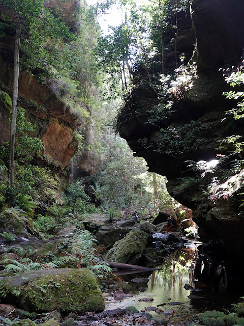 |
| The Grand Canyon |
 |
| There are numerous pools and waterfalls along the way |
 |
| Greaves Creek |
Eventually, I reached the junction at Rodriguez Pass - one of the popular tracks in the Blue Mountains. Sadly the track, and many others in the Grose Wilderness, will be closed for the foreseeable future due to the damage caused by recent bushfires and flooding. After the path junction, the track begins to climb out of the canyon in the direction of Evans Lookout.
 |
| Departing the Grand Canyon |
 |
| Climbing out of the canyon |
 |
| Further climbing through the ferns |
The track climbs a series of steps within another steep-sided valley, passing through a gap in the cliffs. There is a flat section towards the top where there are some views of the cliffs at Point Pilcjher (this is the top of the Horse Track), however, there is still some additional climbing required to reach Evans Lookout and the last section of steps is particularly tough.
 |
| The Carne Wall close to Point Pilcher |
 |
| The final set of steps leading to Evans Lookout |
Before long, I emerged at the top of the steps at Evans Lookout. It has a spectacular view of the Grose Valley and has benefitted from some recent upgrades thanks to the National Parks Authority to make it more accessible — it looks all the better for it.
 |
| The Grose Valley from Evans Lookout |
 |
| Carne Wall and Arethusa Canyon |
 |
| Lockleys Pylon |
At the car park for the lookout is the Cliff Track, a link between Evans Lookout and Govetts Leap Lookout. As its name suggests, the Cliff Track hugs the top of the cliffs, though it is set back from the very edge and views are largely shielded by the trees. It crosses the lush Hayward Gully, named after Willaim Hayward, the first white man to reach the floor of Govetts Gorge in 1847.
 |
| Views through the trees from the Cliff Track |
 |
| The Cliff Track |
 |
| Mount Banks |
 |
| Pulpit Rock and Mount Banks |
The lookout is located just above Govetts Leap, so it is tricky to see the waterfall itself. However, it is situated on the very precipice of the cliffs and has a stunning view of the mossy hanging gardens which cling to the sandstone face. It's one of the few lookouts I've visited where you are actually below the main cliffs, rather than on top of them.
 |
| Barrow Lookout |
 |
| Grose Valley |
 |
| Horseshoe Falls |
 |
| The top of Govetts Leap |
 |
| Horseshoe Falls |
The waterfall falls some 180m over Griffith Taylor Wall, an immense stretch of sandstone that starts from Evans Lookout and ends many kilometres away at Docker Head and Perrys Lookdown. The falls themselves are named for Willam Romaine Govett, the government surveyor who first documented the falls in 1831 (it is unlikely he was the first to 'discover' the area). The word 'Leap' translates to waterfall in old Scottish dialect, though Govett himself was from Devon.
 |
| The view from Barrow Lookout |
Braeside Walk is another path in the local area that has benefitted from some recent maintenance (alongside Popes Glen and the two large lookouts). It sits just below Barrow Lookout at Govetts Leap Brook and provides a means to get back to Blackheath, via the Braeside Road fire trail.
 |
| Braeside Walk alongside Govetts Leap Brook |
 |
| Braeside Walk |
 |
| Braeside Walk |
 |
| There is a small artificial pond that creates a nice swimming hole |
 |
| Stone blocks cross the creek |


No comments :
Post a Comment