This map was created using GPS Visualizer's do-it-yourself geographic utilities.
Please wait while the map data loads...
Route: Bundeena/Beachcomber Avenue, Old Bundeena Tip, Big Marley Firetrail, Marley Head, Coast Track, Wedding Cake Rock, The Waterrun, Coast Track, Wedding Cake Rock Track, Bundeena/Beachcomber Avenue
Date: 27/05/2023
From: Bundeena
Parking: Eric Street
Start Point: Beachcomber Avenue — Bundeena
Finish Point: Beachcomber Avenue — Bundeena
Region: The Royal National Park
Start Point: Beachcomber Avenue — Bundeena
Finish Point: Beachcomber Avenue — Bundeena
Region: The Royal National Park
Route length: 8.0 km
Time taken: 02:29
Average speed: 4.4 km/h
Ascent: 144m
Descent: 143m
Time taken: 02:29
Average speed: 4.4 km/h
Ascent: 144m
Descent: 143m
Points of Interest: Marley Head, Wedding Cake Rock
The Royal National Park (or 'Nasho' to some) is located just south of Sydney. The 150-square-kilometre national park is the oldest in Australia, having been founded in 1879. In fact, internationally, only Yellowstone in the US is older, having been founded a few years earlier. While most of Royal National Park consists of open areas of bush, the coastal cliffs are spectacular and make for some fine hiking.
Wedding Cake Rock is a bit of an Instagram icon thanks to its stark colour and shape, and its imposing position overlooking the Tasman Sea. As such, a way marked track leads from Bundeena directly to the rock and back, however, this short circuit makes better use of the other paths and fire trails in the area.
We arrived in Bundeena mid-morning to find many of the streets full of parked cars. It seems the good weather had tempted many people to The Royal National Park. After finding a spot on Eric Street, we made our way to the beginning of the Wedding Cake Rock Track at the end of Beachcomber Avenue. Instead of following the track, we opted to continue along the fire trail to the old Bundeena Sanitation depot to find an unnamed path that forges a route through the coastal heath. The path is a bit rough and was flooded in several sections during our visit, even after several weeks of dry weather.
After we successfully negotiated the path from Bundeena, we reached the Big Marley Fire Trail, a wide, stony track that has views of the ocean. The fire trail heads south until it meets the Coast Track, The Royal National Park's premier hiking route. As its name suggests, the 30 km track follows the entire coastline of the national park. We'd be using a short section between the fire trail and Bundeena.
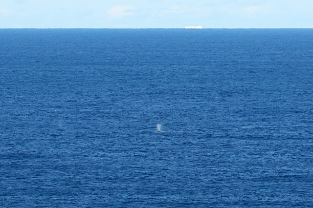
At Marley Head, there are some excellent views of Big Marley Beach and the neighbouring Little Marley Beach. If you are lucky, the headland is the perfect spot to try to spot migrating humpback whales. The best time to see them is between mid-June and mid-July but the migration season runs from May to November.
 |
| The view from Marley Head |
 |
| Big Marley Beach |
 |
| Little Marley Beach |
 |
| Marley Head |
 |
| The distinctive spout of the Humpback Whale |
We spent some time watching the whales going about their business before making our way to Wedding Cake Rock along the Coast Track. Due to the popularity of the Coast Track, it is well-maintained and often consists of elevated metal walkways to protect the landscape.
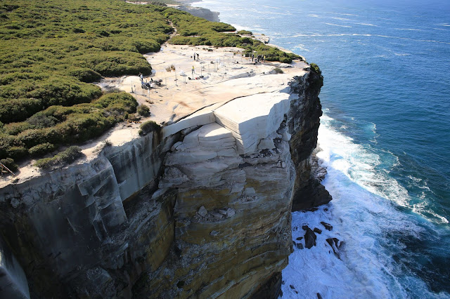
It's only 500m from Marley Head to Wedding Cake Rock. The white colour is caused by iron leaching, which makes the sandstone layers dangerously soft, prone to cracking and at very high risk of collapse. In early 2015, Wedding Cake Rock saw a sudden spike in popularity, with visitor numbers rising sharply from 2,000 per month to over 10,000. Instagram has been cited as the cause for the growth in patronage, with users going to the landmark to take pictures on top of it, typically while performing a stunt. The spike in popularity became concerning for the National Park Service — the increase in visitors has the potential to tip it. Subsequently, the site was closed off in May 2015.
After the closure, a geotechnical assessment of the rock was conducted to determine the stability of the landmark. The study found that the formation was not only unstable but was certain to collapse at any time, with the entire structure being described as "precariously balancing on the edge of the cliff”. A large fence now deters visitors from climbing on the rock, but it still stands, for now.
 |
| The precarious position of Wedding Cake Rock (CNN) |
Leaving the rock behind, we continued north along the Coast Tack which leads past more white cliffs and through the coastal heath, areas that teem with birds and insects. The path crosses the Waterrun, a flat slab of sandstone formed by one of the small creeks that drain into the sea. It's usually dry, however, after a few wet years in Sydney the Waterrun was actually running.
 |
| The Coast Track |
 |
| Coastal cliffs |
 |
| The eroded rocks are formed into some wonderful shapes |
 |
| The Waterrun |
 |
| The Waterrun |
From the Waterrun there is only a small section of cliff-top track before the trail diverged away from the Coast Track to the Wedding Cake Rock Track towards Bundeena. If this hike is a bit short for your liking, then an excellent way to extend it would be to continue along the cliffs to the Balconies and to Jibbon Head, as we have done many times. This area highlights some of the best of The Royal National Park coastline and is probably one of the best hikes in the Sydney area — it comes highly recommended.
 |
| The cliffs at The Balconies |
 |
| The Balconies |
 |
| Bush meets sea |


No comments :
Post a Comment