The Henry Head Walking Track makes a short, leafy foray into the national park before a side branch leads to Grove Street. I would be returning along the Henry Head Track later in the day. Instead, following Grove Street, I made my way to the Jennifer Street Boardwalk. The short, wheelchair-friendly track passes through an area of Banksia scrub – an endangered community unique to the Sydney Basin. Spring is the best time to see the wildflowers in bloom.
 |
| The Jennifer Street boardwalk |
 |
| Looking over the Banksia scrub towards the ocean |
 |
| The Banksia plants that inhabit the national park |
The boardwalk takes you to Cape Banks Road, which carves through the centre of the vast St Michaels / NSW Golf Club. It leads to the Coast Hospital Cemetery, first established in the early 1880s. It served the Coast Hospital, originally a smallpox hospital (people who died of smallpox were required to be buried on the hospital grounds to reduce the spread of the disease). The hospital was built far enough from the city to provide quarantine, and for this reason, the hospital in time became an infectious diseases hospital, also treating patients with influenza, bubonic plague, typhoid fever and leprosy.
 |
| The St Michaels Golf Club |
 |
| Heading to the Coast Hospital Cemetery |
 |
| The Coast Hospital Cemetery |
 |
| The Coast Hospital Cemetery |
Now, the next section of the hike is inadvisable. I followed the 'Coast Fire Trail', which is little more than an overgrown path through the scrub that emerges on the windswept clifftop above the sea. I turned south and walked a short distance to a dilapidated fence before engaging in some modest trespassing. The map shows a north-south path of sorts through here, but there is little on the ground. A large incision into the cliffs blocks the way at the southern end, requiring some unpleasant wading through waist-high vegetation to eventually reach the Cape Bank Management Trail. Following this trail from the cemetery would have been the smarter move.
 |
| On the Coast Fire Trail |
 |
| Looking north towards Little Bay |
 |
| Kamay-Botany National Park |
 |
| Looking out into the Pacific |
 |
| Kamay-Botany National Park |
Close to the management trail is the Life Saver helicopter base, built next to an old artillery emplacement. The helicopters based here are part of the largest non-profit aviation search and rescue organisations in Australia whose sole mission is saving lives.
 |
| The old WWII buildings near the Westpac helicopter base |
 |
| Clouds and rain sweep along |
From the helicopter base, the Cape Banks Management Trail makes its way southwards towards the promontory of Cape Banks, which can be accessed via a small bridge. If you head for Cape Banks, you'll pass a tricky-looking tee that belongs to the golf course, requiring golfers to hit the ball from the headland, over a narrow channel, back to the mainland. Sadly, I did not venture out to Cape Banks as a squally shower arrived at exactly the same time I did, making it an unappealing option.
 |
| Cape Banks |
A path makes its way westwards along the fringe of the golf course until it reaches the Cape Banks Walking Track at Cruwee Cove. The next section of the hike is rather pleasant, following the coast to the Henry Head Lighthouse, located at the formed Henry Head Battery.
 |
| Cruwee Cove |
 |
| Cruwee Cove Beach |
 |
| Cruwee Cove and Cape Banks |
 |
| Cruwee Cove |
 |
| More showers over Cape Banks |
 |
| Henry Head |
 |
| Little Bay |
 |
| Cape Solander on the opposite side of Botany Bay |
 |
| Little Bay |
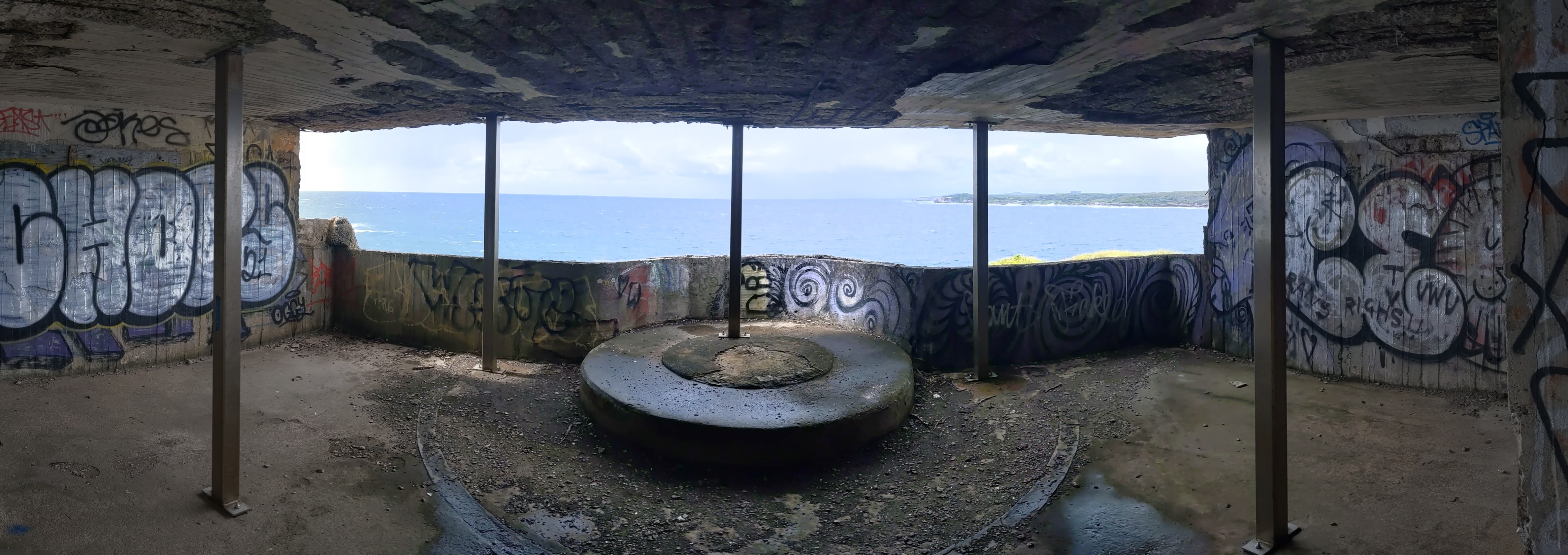
The modest fort at Henry Head was built in 1895 and was armed up until the cessation of WWII. Its purpose was to protect the entrance to Botany Bay. Despite missing out on becoming the famed Sydney Harbour, Botany Bay is probably an economically more important area than its illustrious neighbour, as it is now home to Sydney Airport and the container port.
 |
| Henry Head Battery |
 |
| Inside the fort |
 |
| The observation building, looking out to sea |
 |
| A gun emplacement inside the battery |
I say it missed out on becoming Sydney Harbour, as, when Arthur Phillip arrived with the First Fleet, he was disappointed at the lack of water on the shores of Botany Bay and was dismayed by the large numbers of Aboriginal people inhabiting the place. Shortly after arriving, Phillip left Botany Bay and sailed for Port Jackson, where the first settlement in Australia was made, ultimately becoming Sydney.
 |
| Bare Island with the container port beyond |
The Henry Head Fire Trail leads away from the old fort and into the bush. You can undertake a short detour to Browns Rock, a popular fishing spot; however, you'll have to tackle a reasonable slope to get down to it.
 |
| Henry Head Firetrail |
 |
| Browns Rock |
The fire trail emerges from the bush at Congwong Beach, a usually crowded stretch of sand below the car park at La Perouse. There was not a soul around today, thanks to the dreary weather.
 |
| Congwong Beach |
 |
| Bare Island |
The small peninsula at La Perouse Point is home to several interesting buildings. First is the Macquarie Watchtower, a small, crenellated building that served as a watchtower to overlook the entrance to Botany Bay before becoming a customs station. It is the oldest surviving watchtower in Australia, having been built in 1820, and the only known tower built specifically for colonial border protection.
Second is the fort on Bare Island, accessed along a smart wooden causeway connecting to the mainland (access to the fort itself is limited to guided tours).
 |
| Macquarie Watchtower |
 |
| Bare Island |
 |
| Bare Island |
 |
| Bare Island and Botany Bay |
 |
| Bare Island fort |
 |
| Bare Island fort |
The name 'Bare Island' harks back to the original voyage of Captain Cook, who noted the islet in his journal as 'a small bare island'. The fort was built on the island in the 1880s to protect both Botany Bay and any backdoor routes to Sydney. The waters around the island are now popular with scuba divers.
Finally, La Perouse Point is home to the fine La Perouse Museum, shown below. The museum is housed within the old Cable Station building that once served as Australia's only link to the rest of the world. There are over 2,000 items that document the 1787-1788 expedition of French explorer the Comte de Lapérouse, including the complete Atlas of the Voyage of La Perouse. Lapérouse arrived in Botany Bay a week after the British First Fleet. His expedition was last seen in what is now national parkland before mysteriously vanishing.
 |
| The La Perouse Museum |
 |
| Frenchmans Bay |
 |
| The tomb of Friar Pere Receveur |
Next to the museum is the tomb of Friar Pere Receveur, a Franciscan scientist who was part of the original La Perouse expedition. He died in Australia after being speared in Samoa. The inscription on the tomb in French says, "Here lies L Receveur French Preist of Friars Minor, Scientist in the Voyage Around the World under the leadership of de Laperouse, died February 17th, 1788."
The objects dotted around La Perouse add a great deal of interest to the last section of the hike. In fact, a circuit of the headland is a worthy outing in its own right


No comments :
Post a Comment