The Grand High Tops Track 20-12-2021
This map was created using GPS Visualizer's do-it-yourself geographic utilities.
Please wait while the map data loads...
Route: Pincham Car park, Grand High Tops Track, West Spirey Creek Track, Ogma Gap, Nuada Saddle Track, Point Wilderness, Middle Spirey View, Dow's Lookout, Dows Camp, Dagda Bluff Corner Track, Grand High Tops, Lughs Wall, Lughs Throne, The Breadknife, Grand High Tops Track, Pincham Car Park
Date: 20/12/2021
From: Camp Pincham
Parking: Pincham Car Park
Start Point: Pincham Car Park
Finish Point: Pincham Car Park
Region: Warrumbungle National Park
Route length: 13.5km
Time taken: 04:58
Average speed: 3.0km/h
Ascent: 692m
Descent: 683m
Points of Interest: Bluff Mountain, Lughs Throne, Crater Bluff, The Breadknife, Belougery Spire
The Grand High Tops is regarded as one of the very best hikes in all of Australia. It weaves a route through the dramatic volcanic scenery of Warrumbungle National Park, a geological wonderland of rock domes, towers and spires. Warrumbungle mountains have a rich Aboriginal history that stretches back at least 5,000 years. The name ‘Warrumbungle’ comes from the Gamilaraay language of the Kamilaroi people and is believed to mean ‘Crooked mountains’
The entire area was once an enormous shield volcano, some 50km wide and 1km high. Millions of years of erosion have worn away the softer rocks, leaving behind the weird and wonderful dykes, plugs, and domes of trachyte. The features are clustered around the Grand High Tops and are all named - Belougery Spire, Belougery Split Rock, Crater Bluff, Bluff Mountain, Mount Exmouth and The Breadknife. The Breadknife, a straight wall of jagged rock nearly 100 metres high, is particularly rare and the poster child of the national park.
Located some 6-7 hours northwest of Sydney, getting to Warrumbungle National Park is no mean feat but it is well worth the effort. Not only is the scenery spectacular but it is Australia's only Dark Sky Park (for now), promising amazing views during both the day and the night (if you are lucky to get clear skies). We used the summer break to make the trip up from Sydney, staying for a few nights at the excellent Camp Blackman.
The Grand High Tops hike begins from a car park close to Camp Pincham, a basic campsite named after Alfred Pincham who gave up his lease on the Warrumbungle land in 1952. The National Park took over the management in 1967. The first part of the circuit follows the track that leaves from the car park's southeastern end.
 |
| A memorial to Alfred Pincham - the previous landowner of what is now the national park |
We followed the track (evidently a new construction) through the bush as it heads up the valley of Spirey Creek. After around 1km, the track branches forming the beginning of the Grand High Tops circuit. You can take either direction, however, I have read in several places that anti-clockwise is the best - partly to save the spectacular Lughs Throne towards the end of the hike and partly to take the steep steps at The Breadknife in descent.
 |
| Starting out along the Grand High Tops Track |
 |
| Spirey Creek backed by Mata Rocks |
 |
| Mata Hill |
 |
| Mata Rocks |
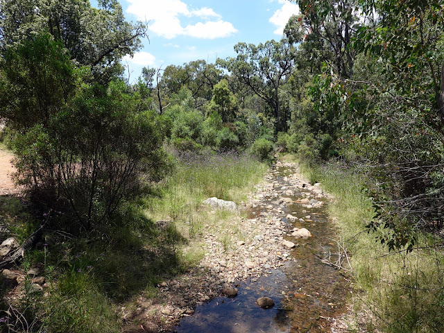
We took a right to follow the West Spirey Creek Track, which follows the creek beneath the watchful eye of Fans Horizon. The only downside of the day was the heat and the mosquitoes. It was both blisteringly hot, with little breeze, and the creek tracks were humming with the biting insects. None of us managed to avoid getting several bites.
 |
| West Spirey Creek |
The West Spirey Creek Track heads uphill along the creek, crossing it several times. After 2km the track starts a more serious climb, winding its way uphill to Ogma Gap, a mountain saddle separating the Grand High Tops from the neighbouring Mount Exmouth. The gap makes a decent spot to camp though water would need to be sought from West Spirey Creek at the bottom of the hill. |
| The track along West Spirey Creek |
 |
| Climbing towards Ogla Gap |
 |
| The camping area at Ogma Gap |
The path continues to climb after leaving Ogma Gap, where the trees begin to thin and a gap at Point Wilderness reveals an extensive panorama.
 |
| Bluff Mountain makes its first apperance |
 |
| Airmid Dome with Mount Exmouth beyond |
 |
| The panorama from Wilderness Point |
 |
| The northern Warrumbungles |
As we approached Middle Spirey View, the scene reveals the side-on profile of the immense Bluff Mountain. It is the largest trachyte lava dome in the Warrumbungle Mountains - the sheer north face is 250m high. Dows Lookout, located along Dows High Tops ridge has the best of the views over the valley.
 |
| Emerging on Dows High Top |
 |
| Bluff Mountain |
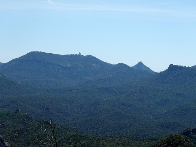 |
| The AAT telescope atop Mount Woorut |
 |
| Bluff Mountain |
 |
| Crater Bluff |
We pressed on, now with an enjoyable breeze, following the path as it makes a steady descent to Dows Camp, another mountain saddle with a campsite. You can follow a detour here to make the steep, 200m climb up Bluff Mountain. The path falls further as it rounds the head of Spirey Creek until it reaches Dagda Saddle and the Dagda Shortcut.
 |
| The Dagda Bluff Corner Track |
 |
| The Breadknife and Belougery Spire |
The shortcut is a means of bypassing the Grand High Tops (though I can't see why you would want to as it's the best part of the hike). We opted for the Grand High Tops Track that climbs up to the sensational area around The Breadknife and Lughs Throne.
 |
| A steeper section of the High Tops Track |
 |
| The Breadknife |
 |
| The rocky Balor Peak |
 |
| Lughs Throne |
 |
| Details on Crater Bluff |
 |
| Crater Bluff |
Many of the features in the park were named by pioneer conservationist Myles Dunphy, who drew heavily on Gaelic mythology; Lugh was the Gaelic sun god. Lughs Throne is the highest part of the range and was close to the centre of what was once the huge Warrumbungle volcano, and it is at the heart of the Grand High Tops. To the east and north are Belougery Spire and the Breadknife, while to the south the scenery is dominated by the 1,094m pillar of Crater Bluff and its distant companion, Tonduran Spire. It's a stunning panorama.
 |
| The Breadknife and Belougery Spire |
 |
| Belougery Spire and Crater Bluff |
 |
| Belougery Spire |
 |
| Belougery Spire |
 |
| Crater Bluff and Tonduran Spire |
The Breadknife sits front and centre of the view north. The outcrop is the remains of a volcanic feature known as a dyke, where molten rock is squeezed through a vertical crack in the surrounding rock and then solidified. The Breadknife is 600m long, 100m high and only a couple of metres thick.
 |
| The Breadknife |
 |
| The Breadknife and a wider view from Lughs Throne |
Crossing the top of Lughs Throne does not take long and soon we were descending again, directly towards The Breadknife and the aptly named Lughs Wall, a 17 million-year-old rock wall that forms part of The Breadknife dyke. The track alongside The Breadknife is quite eroded and loose before it meets the top of a set of steps.
 |
| Sara makes her way down from Lughs Throne |
 |
| Lughs Wall |
 |
| Approaching The Breadknife |
 |
| The immense wall of The Breadknife - bear in mind it is only a few metres thick |
 |
| Belougery Spire |
 |
| Below The Breadknife |
 |
| The beginning of the steps |
In January 2013 about 80% of the national park was destroyed in a bushfire (thought to have been started by lightning) that burned much of the area surrounding the park. The fire razed the extensive network of tracks, steps and railings that give access to the park along with the visitor centre and the museum. Fortunately, no lives were lost.
The current steps are relatively new, having been repaired after the fire. There are a few hundred in total, making a 300m descent (or ascent) down from The Breadknife. At the bottom of the steps, the path continues steeply downhill along Spirey Ramp. Personally, taking the steps in descent would be my advice, leading to this anti-clockwise circuit.
 |
| Descending the many steps |
 |
| The paved path that leads back to Camp Pincham |
Eventually, the steepness subsides and a paved path emerges, following the creek. After Spirey View it's a straight shot back to the car park, following Spirey Creek the entire way. This long section is almost entirely flat and an easy end to the day. A day hike around the Grand High Tops is sensational, but the spectacle doesn't stop at night. As I mentioned at the beginning, Warrumbungle is a Dark Sky Park and you may be treated to a stunning light show in the evenings.
 |
| Spirey Creek |
 |
| The Grand High Tops Track |
 |
| It was a hot hike back to the car park |
 |
| Spirey Creek |
I would highly recommend a trip to Warrumbungle National Park, it's a beautiful place to explore by day and night. Winter is the best time for stargazing but it gets cold in Warrumbungle, so wrap up!
 |
| Our evening visitors |
 |
| Last light over Warrumbungle |
 |
| The famed Southern Cross rises above the horizon |


No comments :
Post a Comment