
This map was created using GPS Visualizer's do-it-yourself geographic utilities.
Please wait while the map data loads...
Route: Fitzgerald Avenue, South Maroubra, Boora Point Walking Track, Magic Point, Boora Point, Fishermans Road, Cromwell Park, Franklin Street, West Escarpment Track, Arthur Byrne Reserve
Date: 23/12/2021
From: South Maroubra
Parking: Fitzgerland Street
Start Point: South Maroubra
Finish Point: Arthur Byrne Reserve
Region: Malabar Headland National Park
Route length: 6.6km
Time taken: 01:29
Average speed: 4.6km/h
Ascent: 188m
Descent: 192m
Points of Interest: Magic Point, Boora Point
The Malabar Headland circuit walk is a short but enjoyable track exploring the Malabar Headland National Park just south of Maroubra Beach. The circuit consists of two trails; the Boora Point walking track following the beautiful coastline, and the Western Escarpment walking track through bushland. It is also one of Sydney's newest walking tracks, having been opened in 2017.
Of note - the circuit navigates around the ANZAC Rifle Range located in the middle of the Malabar Headland. As a consequence, the Boora Point walking track is not accessible during rifle range operations. When shooting practice is scheduled, the park entry gates to the Boora Point track are closed. You can find more details about opening times on the NSW National Parks website. At the time of writing, the typical closure times are;
- Every Saturday (8am - 5pm)
- Every 1st / 3rd / 5th Sunday of the month (8am - 5pm)
I parked at Maroubra Beach, one of the larger of the beaches that run up Sydney's Eastern Suburbs. Due to its popularity, there are large car parks along the length of the beach so finding space should not be a problem. I did, however, arrive during what seemed to be a monsoon, despite a more optimistic forecast. Having driven half an hour to get here, I decided to wait for the storm to pass before setting out.
 |
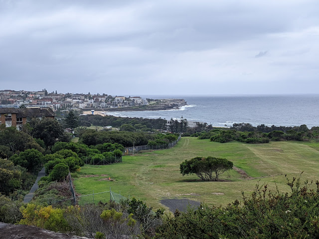
| A cloudy afternoon at Maroubra |
 |
| South Maroubra |
At the southern end of Maroubra Beach is the access to the Boora Point walking track. Opened in April 2017, the 3.7 km track connects South Maroubra to Malabar and is part of a vision to create a continuous walking track from Clovelly to La Perouse, essentially linking the entire coastline from South Head and Botany Bay.
 |
| Rockpools at South Maroubra |
 |
| Entering the Malabar Headland National Park |
The Boora Point Track has superb views of the Sydney coastline and is also home to a number of structures from the Second World War. The Malabar Battery was built in 1943 as a coastal defence battery, along with other batteries in the Botany Bay area, including Bare Island and Henry Head. The Battery consisted of gun emplacements, an underground facility, and even a tramway that was used to transport weaponry. It’s worth exploring the area, with lots of remnants that are still accessible but are in an advanced state of disrepair.
 |
| Heading along the Boora Point Track |
 |
| Maroubra Bay |
 |
| Malabar Headland |
 |
| The new walkway along Malabar Headland |
 |
| Coastal Banksia |
 |
| Magic Point |
 |
| One of the WWII era buildings on Malabar Head |
The coastline at Malabar Headland is characterised by high cliffs and impressive sandstone escarpments, with numerous lookouts and rest areas to enjoy along the way. Along with Kamay-Botany Bay, it is one of Sydney’s best whale-watching spots.
 |
| Malabar Headland |
 |
| Boora Point |
 |
| Malabar Headland |
 |
| Looking back towards Magic Point |
 |
| Pacific panorama |
 |
| Boora Point |
One of the highlights along the Boora Point walking track is Boora Point itself, a small peninsula with rock platforms that provide fantastic views out to the ocean. There are also a few more old military buildings dotted around.
Continuing on, it is possible to remain on the clifftops on the south side of the headland, rather than following the fire trail. The trail eventually leads to Malabar Beach and Cromwell Park. On the north side of the park is the West Escarpment Track.
 |
| Trig pillar at Boora Point |
 |
| Boora Point |
 |
| Heading round towards Malabar |
 |
| Malabar Bay |
 |
| Malabar Beach |
The Western Escarpment walking track provides a connection between Maroubra Beach and Malabar, navigating through unspoiled bushland with fantastic panoramic views. There are various natural as well as man-made vantage points along the way, in addition to several benches where you can soak in the views. The track has a good view of the ANZAC Rifle Range and, unlike the Boora Point Track, remains open when the range is in use.
 |
| The West Escarpment Track |
ANZAC Rifle Range on the headland has been in active use since recreational target shooting first began in the 1850s, and is believed to be the oldest rifle range in Australia. It was previously known as the Long Bay Rifle Range and was renamed ANZAC Rifle Range in 1970 by the Army as a tribute to the rifle club members who served the nation during two World Wars and the Korean Campaign. The range has hosted numerous national and international shooting competitions including the prestigious Empire Matches, the Bicentennial Shooting Championships and the annual NSW Queen's Prize competitions.
 |
| The ANZAC rifle range |
From the range, the track descends some metal steps into the Arthur Byrne Reserve, adjacent to the South Maroubra Surf Life Saving Club. The path through the reserve leads back to the parking area at South Maroubra.
 |
| Maroubra |
 |
| The West Escarpment Track |
No comments :
Post a Comment