Lindeman Pass 13-03-2021
This map was created using GPS Visualizer's do-it-yourself geographic utilities.
Please wait while the map data loads...
Route: Wentworth Falls Station, Falls Road, Princes Rock Lookout, Undercliff Track, Den Fenella, Overcliff Track, Lyrebird Lookout, Empress Lookout, Isobel Creek, Nature Track, Grand Cliff Top Track, Inspiration Point Track, Moya Point Lookout, Roberts Pass, Lindeman Pass, Dash's Cave, Gordon Falls Lower, Microstrobos Falls, Leura Falls, Federal Pass, Jamison Lookout, Prince Henry Cliff Walk, Tallawarra Lookout, Three Sisters Track, Echo Point, Echo Point Road, Lurline Street, Katoomba Station
Date: 13/03/2021
From: Wentworth Falls
Parking: N/A
Start Point: Wentworth Falls
Finish Point: Katoomba
Region: Blue Mountains National Park
Route length: 13.4 miles (21.5km)
Time taken: 08:30
Average speed: 1.7 mph
Ascent: 963m
Descent: 792m
Points of Interest: Wentworth Falls, Den Fenella, Roberts Pass, Lindeman Pass
Update October 2022:
LINDEMAN PASS HAS BEEN SIGNIFICANTLY AFFECTED BY A MAJOR LANDSLIDE BELOW GLADSTONE LOOKOUT
Read any guidebook for the Blue Mountains, and none will likely mention Lindeman Pass, even though it's marked on local maps as clear as day. The route between Wentworth Falls and Katoomba is logical, yet receives very few visitors, unlike the neighbouring Federal Pass. Why is this? I set off to find out.
The history of the pass is an interesting one. It was the brainchild of Charles Lindeman, who took it upon himself to devise and construct the missing link between Katoomba and Wentworth Falls. He personally surveyed the route, linking several old mining routes and passes in the valley. All was going well, until 1911, when local Katoomba business owners began to object, fearing they would lose their business to Wentworth Falls. The anti-German sentiment at the outbreak of WWI was the final nail in the coffin for Lindeman Pass, despite only 200m left to complete.
The pass fell into decay until the 1980s, when Jim Smith and Wilf Hilder made attempts to re-open the track and welcome a new generation of bushwalkers to the Blue Mountains. It has never officially been completed, but Jim Smith's work and documentation have made it more popular – keeping the track somewhat defined.
I decided to use Lindeman Pass as originally intended by hiking from Wentworth Falls to Katoomba and allowing myself plenty of time to do so. It was early morning when I arrived at Wentworth Falls station with a fine, dry day on the horizon.
The first part of this hike was through some familiar territory at Wentworth Falls; however, a long march from the train station is necessary to reach the cliffs. Normally you could hike the Charles Darwin Track along Jamison Creek, which is very pretty; however, it is currently closed while they repair storm damage. Instead, a simple hike down the arrow-straight Falls Road leads to the car park.
 |
| The first lookout of the day at Wentworth Falls |
I made my way downhill to the lookout at Princes Rock, which has a superb view of the towering waterfall – perhaps only bettered by Rocket Point on the opposite side of the valley. The lookout track then links up with the Overcliff Track, which heads westwards along the clifftops. The Overcliff Track has recently been renovated and is in excellent condition.
 |
| Mount Solitary |
 |
| Wentworth Falls seen from Princes Rock |
 |
| Wentworth Falls |
 |
| National Pass descends the cliffs next to Wentworth Falls |
Around halfway along the Overcliff Track is a junction with a smaller trail into Den Fenella, a place I have passed by several times but never ventured into, so this time, I decided to take a look.
 |
| The Overcliff Track |
Turns out it's a fabulous little place, an isolated rainforest gully clinging to a crevice in the cliffs. The track follows the gully before winding down a steep set of steps and crossing a bridge before reaching a lookout. Truth be told, the gully is more impressive than the lookout in my view.
 |
| Den Fenella |
 |
| Den Fenella Lookout |
 |
| Den Fenella Creek |
Returning to the Overcliff Track, I pressed on to Empress Lookout and then down the steep wooden steps towards the famed Valley of the Waters. Instead of heading into the valley, I followed the Nature Track instead, crossing the top of Empress Canyon as I continued my westward journey. My aim was Roberts Pass, located some distance further along the cliffs.
 |
A beautiful view of the Jamison Valley from Breakfast Point Lookout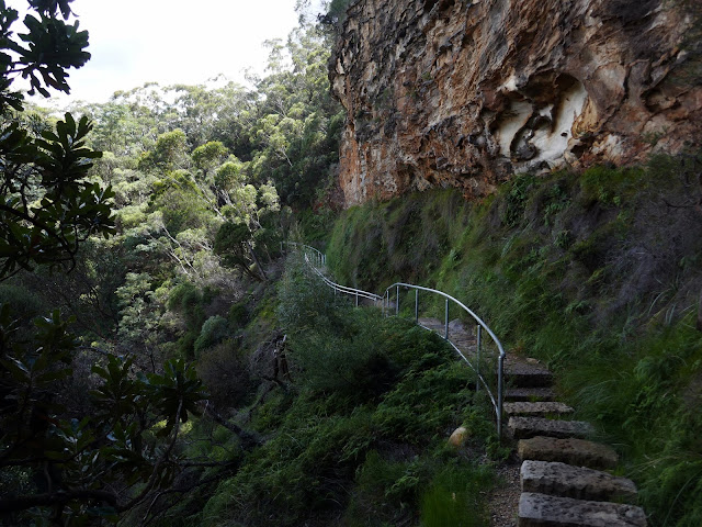 | | Overcliff Track |
|
 |
| Descending the steps towards Valley of the Waters |
 |
| Valley of the Waters Track |
After crossing Empress Canyon I joined the Grand Cliff Top Track which is not as grand as its name suggests. It makes a fairly arduous climb up the hillside before a long route around the edge of a golf course, with precious little cliff top to be found. If anything, it's a means to an end as it allows you to get onto the Inspiration Point Track and then Roberts Pass.
 |
| Climbing the Grand Clifftop Track |
 |
| The track at Fairmont Golf Course |
The Inspiration Point Track descends through the bush to the Moya Point lookout, which also has a good view of Wentworth Falls, if not a little distant. Here you will find the top of Roberts Pass, which provides an unusual means of bypassing the vast Blue Mountains cliffs.
 |
| Wentworth Falls seen from Moya Point |
 |
| Wentworth Falls |
Roberts Pass was originally just known as 'The Pass'. It is not known who the pass was named after, but it has been suggested that it may be Sir Alfred Roberts, a surgeon who lived and died in Wentworth Falls. The first section snakes downhill and can be slippery when wet. Recent rain has damaged this top area, but it is by no means difficult.
 |
| A sign marks the top of Roberts Pass |
 |
| Storm damage at the top of Roberts Pass |
 |
| A rail guides you to the steps within the rocks |
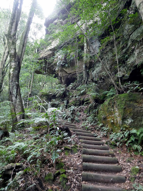
The track leads down to a cleft in the rock where a switchback ladder has been built, seeming to be within the confines of the cliff itself. You may need to remove your pack to ease around the corner inside the rock. Once past this obstacle, the track switchbacks down to meet Lindeman Pass.
 |
| The steps within the cliff |
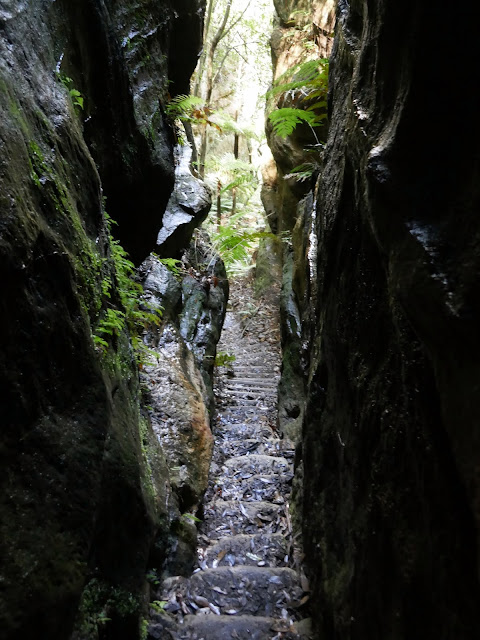 |
| Emerging from the cleft in the rocks |
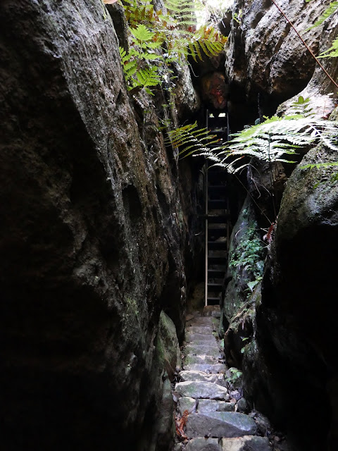 |
| Looking back to the bottom of the ladder |
 |
| Another view of Wentworth Falls from Roberts Pass |
 |
| Roberts Pass |
I actually wrote the next few paragraphs on the train ride home from Katoomba to capture some of the key details of Lindeman Pass as I found it. However, the extreme rainfall in March 2021 may have changed track conditions considerably – I am aware of some new landslides but not where they have occurred; they are likely in the unstable section on the east side of Sublime Point.
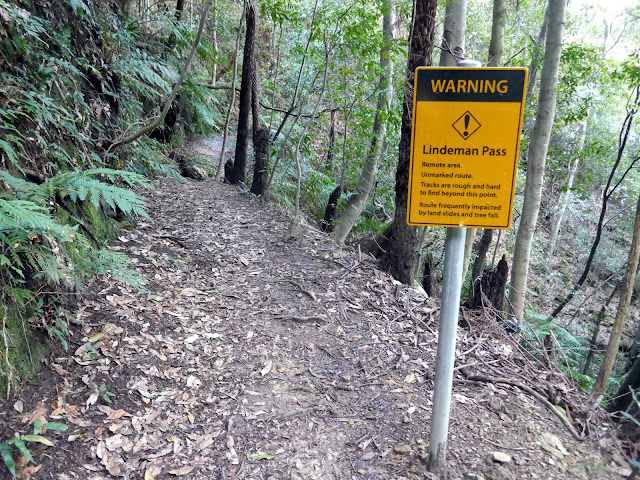
Lindeman Pass begins from the bottom of Roberts Pass, where a reflective sign makes it quite clear this route is not for the faint of heart. That said, the first few hundred metres of the path is in good condition and easy to follow.
 |
| Lindeman Pass begins at the foot of Roberts Pass |
 |
| A reflective sign warns the unaware |
 |
| The first few metres of the path are in fairly good condition |
 |
| Lindeman Pass |
The first obstacle is a fairly recent landslip at the first creek west of Roberts Pass, likely caused by the huge storms in February 2020. It's quite small, and, because it is recent, the route across is pretty clear as trees have not begun to grow over it. The route across is marked out by a couple of low cairns perched on the rocks.
 |
| The first landslide |
 |
| Lindeman Pass crosses the landslip fairly easily |
 |
| Keep an eye out for these short cairns |
 |
| Looking back across the landslip |
 |
| After the first landslide, Lindeman Pass climbs a short rock step – notice the pink ribbon on the tree |
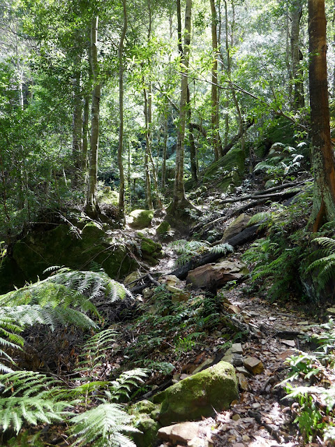
From here, the path is fairly uneventful, with a couple of short climbs breaking up the general flatness of it. Before long, it heads into the moist gully of Gladstone Creek, where the bottom of Gladstone Pass can be found, snaking off into the trees. A short distance further is Dash's Cave, accessed by the smallest of diversions from Lindeman Pass.
 |
| The Jamison Valley has seen through a gap in the trees |
 |
| Lindeman Pass |
 |
| Gladstone Creek gully |
 |
| This short rocky strip is at the bottom of Gladstone Pass |
Dash's Cave is, in fact, a severe sandstone overhang. It is home to a rusty billy with a logbook and an old pickaxe. It is named after Charles Lawson Dash in honour of his involvement with Lindeman Pass. Charles Dash was a local businessman and argued in favour of the Katoomba Council completing Lindeman Pass.
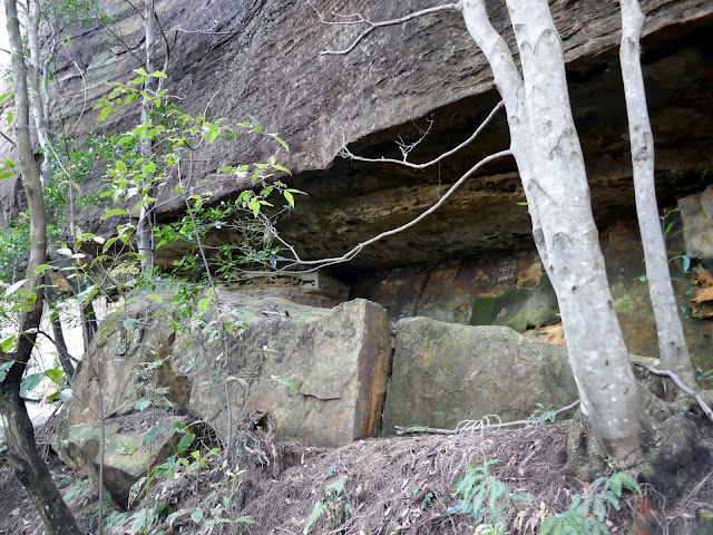 |
| Dash's Cave |
 |
| Inside Dash's Cave |
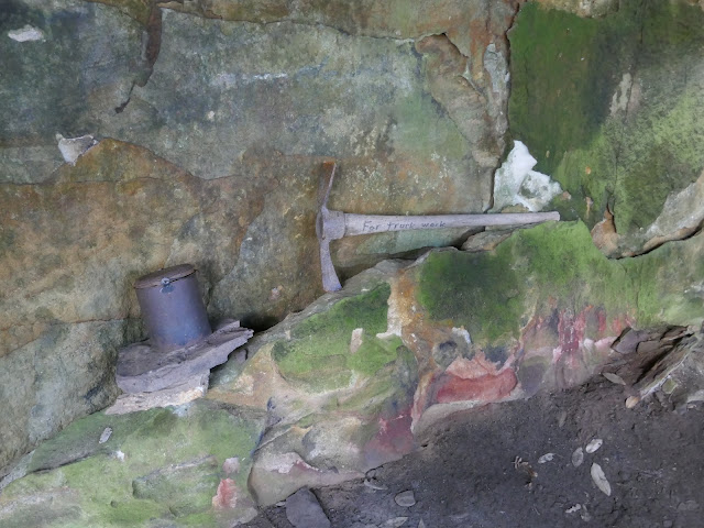 |
| The billy and axe |
 |
| I'm not sure if this is a joke or not |
 |
| The logbook inside the billy |
If you visit the cave, leave the same way you entered instead of continuing out the other side; this leads nowhere. The next section of Lindeman Pass, between Dash's Cave and Copeland Pass, is arguably the most challenging.
First, another recent landslip is negotiated, but it shouldn't pose too many problems, followed by a second a short distance later, this time bypassed by a loose, stony ledge at the foot of the cliffs.
 |
| The second landslide - more of a rockfall |
 |
| Follow the cairns across this landslip |
 |
| Views along the Jamison Valley where landslides have opened up the views |
 |
| Rounding the third landslide is a little exposed, it passes along this crumbling shelf |
 |
| Looking down upon the third landslide – it's a big one |
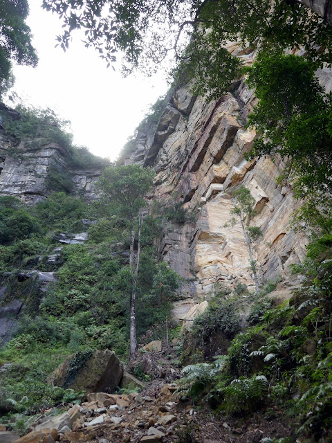
There's a short length of fairly easy track before Lindeman Pass enters the area of older landslides which have since had trees and ferns regrow over them. Therefore, following the path is pretty essential. The Jamison Project describes two landslides here, but, truth be told, it felt just like one long one as the path ducks and weaves through the vines and trees, occasionally passing over or under fallen logs. A mixture of pink ribbons and plastic markers has been tied to the trees, so keep an eye out for those as they mark the route.  |
| Lindeman Pass |
 |
| Lindeman Pass is often right up against the base of the cliffs |
 |
| Some fallen trees are negotiated |
 |
| The gnarly section along the east side of Sublime Point – it's arduous and takes time |
 |
| Keep a lookout for these ribbons |
 |
| Further signs you are on the right track |
 |
| A gap created by numerous landslides |
 |
| Sometimes the ribbons are replaced by plastic tags nailed to the trees |
 |
| Under or over? |
 |
| Lindeman Pass |
Eventually, I reached the foot of Copeland Pass, which descends from Sublime Point above. It is marked by a low cairn next to the Lindeman Pass track and offers a tricky route back to the top of the cliffs. If you make it to this point, you have completed the most challenging section of Lindeman Pass.
 |
| The cairn at the foot of Copelands Pass – things ease from here westwards |
 |
| The track is in a much better state of repair on the west side of Sublime Point |
Once around the southern tip of Sublime Point, the track improves markedly. This is because the west side of the ridge is considerably drier and not prone to its landslides on the east side. It is generally easy to follow once again and remains so for much of the rest of the route. Occasional ribbons highlight where the path goes if it is ever unclear.
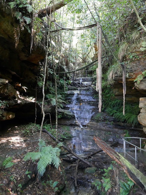
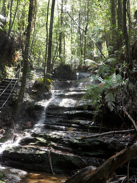
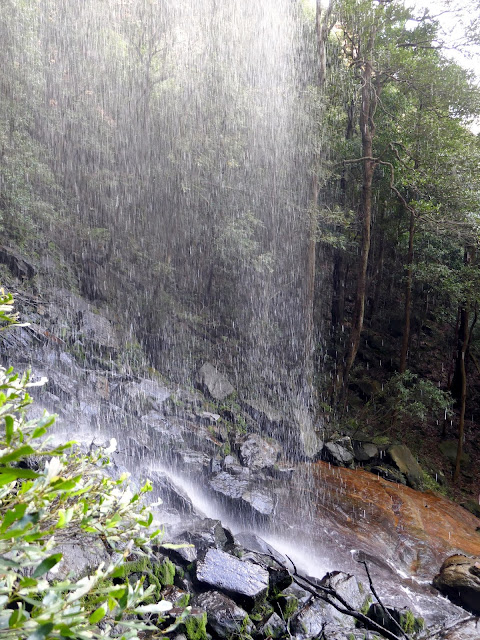
It passes by Walford Falls and then Lindeman Falls before reaching one of the day's highlights, Gordon Falls. As you approach the bottom of the waterfall, make note of the screen of trees behind the cascading water, Lindeman Pass actually goes behind them and is remarkably dry, save for a short section after the waterfall which is very boggy. Almost immediately after Gordon Fall is Microstrobos Falls (named after a fern) where Lindeman Pass simply hops across the stones, but keep closer to the cliffs if you can. After the waterfall, Lindeman Pass climbs up slightly before continuing on.
 |
| Lindeman Falls |
 |
| Lindeman Falls |
 |
| Gordon Falls |
 |
| The track through the trees behind Gordon Falls |
 |
| Behind Gordon Falls |
 |
| Gordon Falls |
 |
| Microstrobos Falls |
 |
| The bottom of Microstrobos Falls |
 |
| A look back along the Sublime Point cliffs |
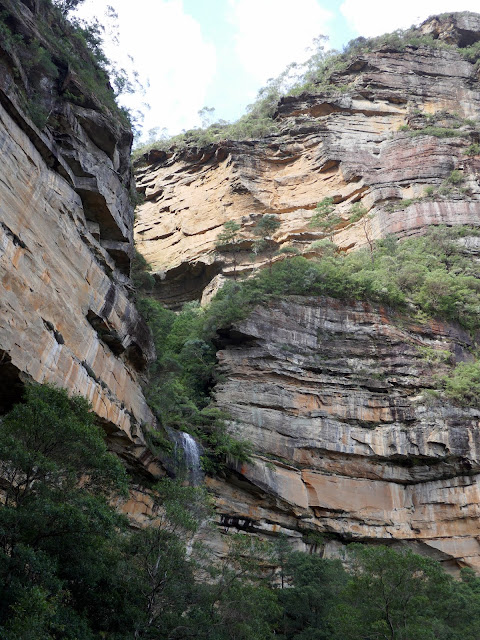 |
| Gordon Falls |
After the waterfalls, you're on the home stretch (though take care not to drop too low otherwise you may miss the track taking you into Leura Creek gully). Again, following the path will lead you to a rock with a sad-looking ladder at the bottom to aid your descent, assisted by a newish-looking rope tied to the tree above. After the ladder, Lindeman Pass descends via a switchback and then passes beneath two fallen trees. After crossing a couple of streams, the path turns sharply to climb a short distance, following the creek before pressing on westwards.
 |
| Mount Solitary |
 |
| The short ladder – it's actually a little trickier to descend than it looks |
 |
| An obstacle course of fallen trees |
 |
| Lindeman Pass |
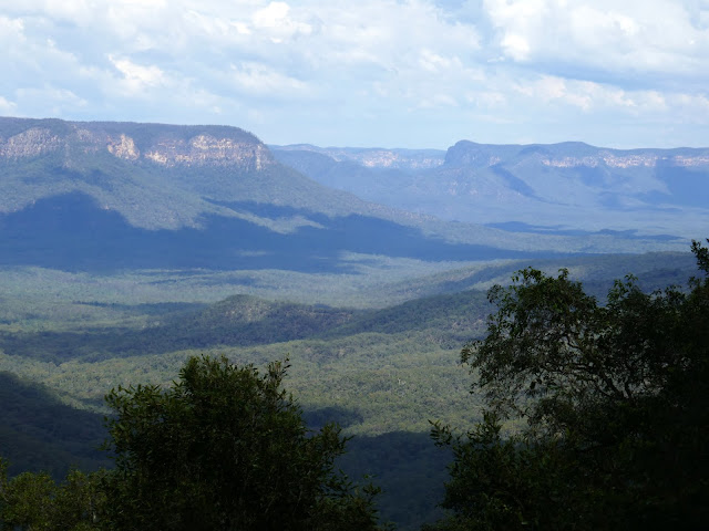
The views open up through the next section as Lindeman Pass heads along a shelf at the base of the cliffs, with excellent views of Mount Solitary. Once around the corner, the track descends steeply to the base of Leura Falls, following some tape markers through the trees. Crossing the creek can be tricky, and the rocks are extremely slippery. There's a concrete manhole on the opposite side; the path climbs the slope immediately behind it.
 |
| Mount Solitary |
 |
| Lindeman Pass as it approaches Leura Falls |
 |
| Mount Solitary and Lindeman Pass |
 |
| Leura Falls |
 |
| Leura Falls |
 |
| Lindeman Pass, having climbed out above the sewer inspection chamber |
 |
| The western end of Lindeman Pass |
From here the final short section is easy. It emerges onto Federal Pass at Linda Falls. It took me 3 1/2 hours to hike Lindeman Pass from the base of Roberts Pass and, in hindsight, the path was generally easy enough to keep an eye on, though it is pretty slow in places. Assistance from the Jamison Project track notes was key in a couple of places, particularly at Leura Falls, where the climb behind the manhole is not obvious.  |
| Federal Pass at Linda Gully |
Things weren't quite finished there though. Despite being back on the more obvious paths, there was still the task of reaching the station in Katoomba. There are several choices and I decided on a longer route to Echo Point and then along the main road into the town. This meant hiking a section of the Prince Henry Clifftop and seeing the Three Sisters - always a favourite of mine.
The wooden steps of Federal Pass give way to some narrow metal steps which snake their way up through the bush alongside Linda Creek. This section of Federal Pass was originally constructed in 1894, and some of the original fabric remains, including earth benching and stone steps. Otherwise, the rest has been upgraded.
 |
| Federal Pass as it climbs alongside Linda Creek |
 |
| Federal Pass |
 |
| Federal Pass at Fern Bower |
 |
| Federal Pass at Fern Bower |
A final long narrow set of steps takes Federal Pass to the junction with the Amphitheatre Track (currently closed due to landslides). The path climbs further along Linda Creek before it reaches Jamison Lookout overlooking the valley. A short distance further is the Prince Henry Cliff Walk and Solitary Restaurant.
 |
| Jamison Lookout |
The Prince Henry Cliff Walk is one of the highlights of the Katoomba area. The path links the clifftop lookouts between Scenic World and Gordon Falls. It's normally very busy, but since international travel into Australia is currently banned, it has never been quieter. The track passes Honeymoon Point and Tallawalla Lookout before it just juts out into the valley at the top of the Giant Stairway behind the famed Three Sisters.
 |
| A hanging swamp along the Prince Henry Track |
 |
| Tallawarra Lookout – Lindeman Pass runs beneath the cliffs |
 |
| Lady Game Lookout behind the Three Sisters |
 |
| Meehni – the tallest of the Three Sisters |
 |
| Looking towards The Ruined Castle |
The track continues a short distance to Echo Point and the Queen Elizabeth Lookout – arguably the most popular of all the lookouts in the Blue Mountains.
 |
| The Queen Elizabeth Lookout at Echo Point |
Echo Point is usually a busy place. Under normal circumstances, most (if not all) of the tours from Sydney coincide at this location and disgorge hundreds of daily passengers, though it was much quieter today. Obviously, COVID has had its effect; however, in the year we've been in Australia, the lookout has been expanded and upgraded to create more room for visitors. The view of the Three Sisters from the lookout is the defining image of the Blue Mountains – one you'll no doubt find with a quick Google search.
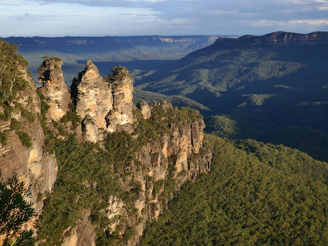 |
| Golden Hour at the Three Sisters |
 |
| The Three Sisters – Meehni, Wimlah and Gunnedoo |
 |
| Mount Solitary and The Ruined Castle |
 |
| Mount Solitary |
I arrived in time to enjoy the sunset over the lower Blue Mountains before heading back into Katoomba to catch the train back to Sydney. It was 10pm by the time I arrived home, having spent a full day traipsing around the bush on Lindeman Pass. It certainly was an adventure, though not as challenging as I had anticipated – I guess part of that was down to preparation and the track notes from the Jamison Project. That said, given the poor weather NSW has received, I imagine new challenges are awaiting those who venture down to Lindeman Pass.


Nice writeup. I ran/hiked this recently from Katoomba to Wenty starting about 3 hrs before sunset and continuing by headtorch. Lost the "track" twice which wasn't fun in the dark. Every time it intesected with a creek or a recent (large) tree fall it required some experienced guesswork as to which way to head. A couple of times I was contemplating my fate if I were forced to spend the night wrapped up my emergency blanket next to a rock which would not have been pleasant in the middle of winter. Only got to see the first half so a bit disappointing. Poor planning on my part. Absolutely stunning track/route that definately requires hiking/navigation experience. Will be going back again and starting earlier to see it in all its glory.
ReplyDeleteThanks! I imagine it's a bit intimidating down there just you and a headtorch. Great effort though
DeleteFantastic notes, so good to see it is still doable but tricksy. Microstrobos is actually a dwarf pine, critically endangered. Found only between wenty falls and Katoomba in the splash zone, so suffers badly in droughts.
ReplyDelete