Mermaids Pool & Tahmoor Gorge 10-10-2020
This map was created using GPS Visualizer's do-it-yourself geographic utilities.
Please wait while the map data loads...
Route: Arina Road, Potholes Track, Diesel Pass, Mermaids Pool, Mermaids Lookdown, River Gorge Lookout, Jacks Pass, Dog Crossing, Bargo River, Tahmoor Gorge, Olympic Pool, Split Waterfall, Hip Crossing, Rosies Pass. Matilda Track, Potholes Track, Arina Road
Date: 10/10/2020
From: Bargo River
Parking: Arina Road
Start Point: Bargo River
Finish Point: Bargo River
Region: Bargo State Conservation Area
Route length: 5.6 miles (7.7km)
Time taken: 05:04
Average speed: 1.3mph
Ascent: 289m
Descent: 281m
Points of Interest: Mermaids Pool, Tahmoor Gorge
This hike is often referred to as a hidden gem, at least it was at one point in its life. The area is not part of a national park and has remained largely undisturbed until recently. The existence of the paths around the rivers and canyons is thanks to the adventurous endeavours of Robert Sloss and Jo Hafey who, after moving to the area in the late 90s, spent the last few decades marking, clearing, building and mapping a route through the Tahmoor Gorge.
This is not a bushwalk of the like you will find in an NSW National Park - signage is of a more agricultural nature but it should not pose any challenges to those with some hiking experience.
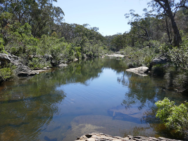
We parked up in a large, unsigned layby close to the Rockford Road bridge which crosses Bargo River. At the north end of the layby is the beginning of the track which first leads to Mermaid's Pool and then on to Tahmoor Gorge. After getting our gear ready, we immediately passed under the bridge and were down on the beautiful banks of Bargo River. |
| Bargo River |
 |
| Bargo River |
 |
| Bargo River |
 |
| Bargo River |
Like many of the rivers in this area, Bargo River carves a route through the Hawkesbury Sandstone which is synonymous with most of the Sydney area. It forms flat rock platforms along either side which are often the best and easiest way to make your way along the river.
 |
| The Potholes Track follows the right side of Bargo River |
 |
| Bargo River |
 |
| Much of the first part of the hike is along the flat sandstone slabs next to the river |
We followed the river downstream along the Potholes Track until we reached Diesel Pass where you have to escape the confines of the river to avoid an impassable section. The pass gets its name from the old, rusty diesel engine which stands at the bottom. The Potholes Track was the first route to be explored and tagged by Robert and Jo in 1998.
 |
| The old diesel engine at Diesel Pass |
 |
| Keep your eyes peeled for many of the hand-marked signs |
 |
| Looking down on Bargo River |
Once at the top, we followed the little arrows nailed to the trees that say "mermaids". These will direct you to the pools. The path passes a branch down to See Thru Pools (an optional diversion to some pretty cascades) and on to Mermaids Pool, one of the real highlights of the walk.
To get to Mermaids Pool, first, you'll need to clamber down some rocky steps, following the line of an indistinct path. Once you reach the river, head right to reach Mermaid's Pool. The pool is as the name described, a large body of water nestled in the sandstone, fed by a waterfall and hemmed in by tall cliffs. Some rocky ledges around the pool will always attract those wanting to jump in, despite the warnings painted on the floor - numerous accidents have occurred in this spot, even a few deaths. Getting out of the pool is also extremely hazardous.  |
| Bargo River |
 |
| Bargo River at Mermaid's Pool |
 |
| Mermaid's Pool |
 |
| The tumbling Bargo River |
 |
| The overhang which tempts people to jump into the pool (not recommended) |
 |
| Cascades on Bargo River |
 |
| Mermaid's Pool |
It's not possible to make your way around the pool other than by returning the way you came, up to the high-level path. We did so and continued on, emerging at the River Gorge Lookout which looks directly back towards Mermaid's Pool.
 |
| The view of Mermaid's Pool from Gorge Lookout |
 |
| Bargo River as it drops into Mermaid's Pool |
 |
| Continuing to the top of Jacks Pass |
Continuing on, we eventually reached a junction in the path where a red metal toolbox has been fixed to a pole. Inside are a few helpful maps and a logbook courtesy of Robert. In fact, as we were reading the logbook we bumped into Robert as he was heading, tools in hand, to do some work on the path into the canyon. He spends most other days maintaining the paths, particularly after a flood in 2016 damaged most of the path work in the canyon.
 |
| The toolbox at the top of Jacks Pass - be sure to grab a map to help guide you through the gorge |
From the toolbox, Jacks Pass leads steeply down to the canyon. Robert is in the process of fixing some metal hand chains to help with the steepest sections but most people should have no problem reaching the river. The path leads to a jumbled pile of boulders in the river which need to be crossed. White markers painted on the floor indicate the best way.
 |
| Descending Jacks Pass |
 |
| Bargo River at the bottom of Jacks Pass |
 |
| Crossing the jumbled boulders at 'Dog Crossing' |
 |
| You will spend most of your hike on the right-hand side of the river |
 |
| Tahmoor Gorge |
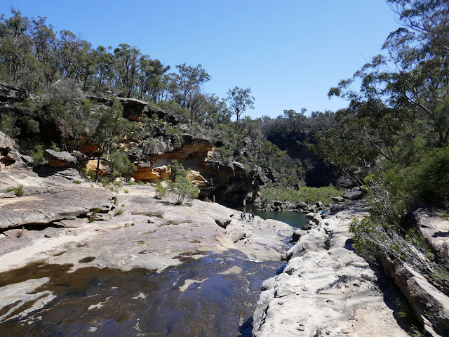
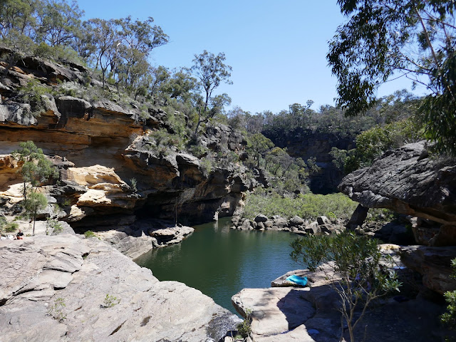
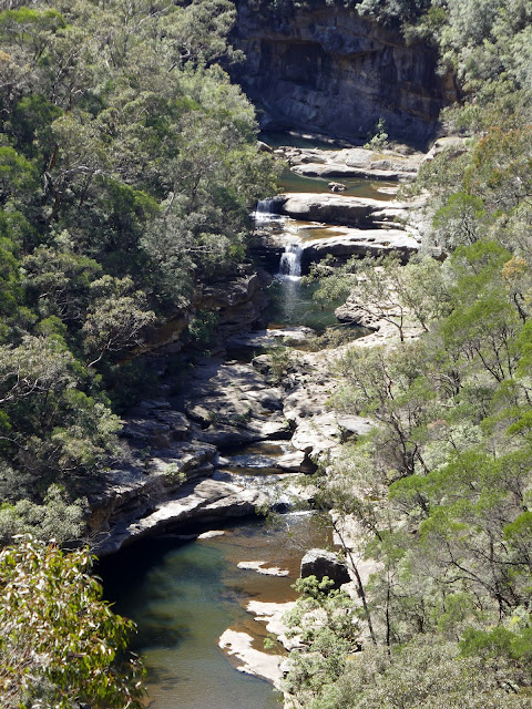
Once over the boulders, we entered the gorge proper and it's a spectacular place. There's no path through the gorge here, instead, we just followed the easiest course along the rocks. The river flows to a large bend in the canyon where it has formed a large pool - the Olympic Pool according to the map we grabbed from the toolbox. It's a quite stunning location. |
| Tahmoor Gorge |
 |
| Bargo River in Tahmoor Gorge |
 |
| Tahmoor Gorge |
 |
| Tahmoor Gorge |
 |
| The large Olympic Pool |
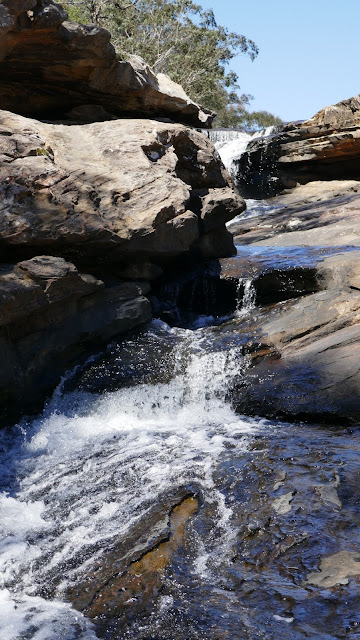
Continuing from the Olympic Pool, markers point out the best way to negotiate the next section, by following a path that leads away from the river along the right side of the canyon. We encountered one of Australia's Red Bellied Black Snakes lounging along this section. The path passes above Split waterfall before making a short descent back to the river. We returned upstream to have a swim in the pool below the second waterfall.
After drying off, we pressed on.
 |
| A view down to Split Waterfall |
 |
| Split waterfall |
 |
| Split waterfall and a perfect swimming hole |
 |
| Tahmoor Gorge |
 |
| The natural stone bridge in Tahmoor Gorge |
 |
| Tahmoor Gorge |
Immediately after the waterfall, the path continues on the left side of the river, having crossed via a natural stone bridge (look for the white painted flashes on the floor). The elevated rock platform leads to another crossing point where some metal boards have been laid over the river to help keep feet dry (this is Hip Crossing as you may end up having to wade across the river). Beyond Hip Crossing the path becomes a bit vague but ultimately keeps to the right of the river. We reached the foot of Rosies Pass where a series of stone steps have been placed which climb steeply out of the valley. |
| Approaching the foot of Rosies Pass |
 |
| Bargo River |
 |
| Rosies Pass heads off to the right |
 |
| Beginning the short climb out of the valley along Rosies Pass |
 |
| Looking down to the canyon from the top of Rosies Pass |
 |
| The Matilda Track |
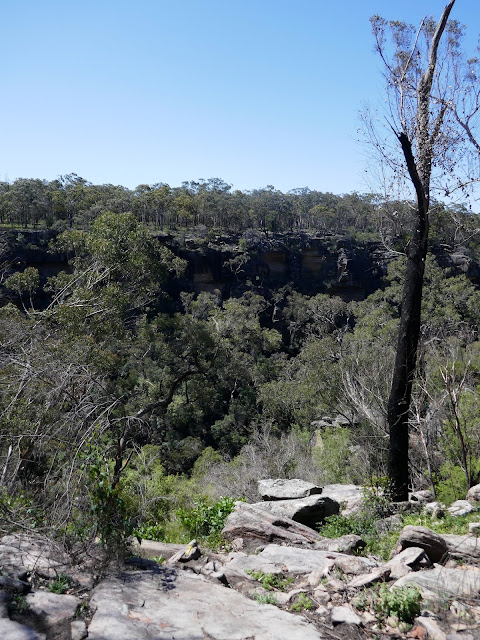
Once at the top of Rosies Pass, we paused to catch our breath before continuing on. Some more gradual climbing is necessary along the Matilda Track as we headed back towards the junction at the toolbox. The path, now above the river gorge, has a series of lookouts that provides views across the surrounding landscape and down into the canyon itself.
 |
| Tahmoor Gorge |
 |
| A view of the canyon from the Matilda Track |
 |
| Split Waterfall and the natural stone bridge |
 |
| Tahmoor Gorge |
 |
| The Matilda Track |
Eventually, we made it back to the toolbox. From here, it's a simple case of retracing the route to Mermaid's Pool and Diesel Pass then, back to the car. Mermaid's Pool was far busier now and we watched several people make the 25m jump from the ledge we stopped at earlier in the day. Luckily, no accidents today. One group has even managed to set up a slackline high over the pool but don't ask me how they managed to rig it up. |
| Gorge Lookout |
 |
| Mermaid's Pool was far busier than it had been in the morning |
 |
| Slacklining over Mermaid's Pool |
 |
| Descending Diesel Pass to Bargo River |
 |
| Bargo River |
 |
| Bargo River |
This is a tremendous hike through some stunning scenery. It's thanks to the endeavours of Robert and Jo that it is as accessible as it is. I have read that the area is being considered as a national park - hopefully, if this was the case NSW National Parks can continue Robert's hard work.


No comments :
Post a Comment