Discover the ultimate Sydney inner harbour loop on this scenic 5.5 km circuit tracing the shores of Rozelle Bay and Blackwattle Bay. Perfect for a quick urban escape, this 1.5-hour walk kicks off from Federal Park and weaves through the lush, 17-hectare waterfront expanses of the Glebe Foreshore Parks. You will soak in spectacular views of the iconic Sydney CBD skyline, stroll past the bustling Sydney Fish Market, and conquer the soaring pedestrian path of the impressive Anzac Bridge.
Rozelle Bay, Blackwattle Bay & Anzac Bridge
📍 SYDNEY AND SURROUNDS
Distance
5.5 km
Duration
01:20 hrs
Elev Gain
+47 m
Elev Lost
-50 m
| Date |
03 May 2020 |
| Starting Point |
Rozelle Bay |
| Difficulty |
Easy |
| Pace / Gear |
4.1 km/h — Light day pack |
| Highlights |
Glebe Point, Anzac Bridge |
🗺️ Interactive Route Map
Pinch or use wheel to zoom
Like Iron Cove (the subject of last week's walk), Rozelle Bay and Blackwattle Bay are two of Sydney's inner harbour bays. While perhaps not quite as picturesque as Iron Cove, the circuit of the two bays includes crossing the AnzacBridge – an impressive structure itself but overshadowed by the more famous Sydney Harbour Bridge.
This walk starts from Federal Park, located on the Glebe foreshore. A combination of four parks makes up the Glebe Foreshore Parks, Federal Park being joined by Jubilee Park, Bicentennial Park and Blackwattle Bay Park to create 17 ha of open space and sports facilities in the heart of Sydney. Immediately, the foreshore has an impressive view of the Anzac Bridge and the Sydney CBD skyline.
 |
| The busy Rozelle Bay |
We passed through Federal Park, crossing Johnstons Creek via a footbridge. The creek is currently undergoing a transformation with the aim of restoring much of the old wetlands that once existed along the shore of Sydney Harbour. The naturalisation aims to add a further 6ha of parkland in addition to the saltmarshes. While it is a bit of a building site at the moment, I imagine it will be much improved in a few years' time.
 |
| The Anzac Bridge and (currently under construction) Crown Sydney hotel |
 |
| Palm trees in Jubilee Park |
Across the wooden bridge, we entered Jubilee Park. Jubilee Park and the neighbouring Bicentennial Park are essentially one large area split into two parks, with the foreshore path making its way through the latter. The park, created in 1988 to celebrate the bicentenary of white settlement of Australia, was the result of a fifteen-year campaign by the Glebe Society. In the early twentieth century, there was a public wharf here with a ferry service from Glebe Point – until 1988, this small reserve was the only public access to the waterfront on Rozelle Bay.
 |
| Bicentennial Park |
 |
| Bicentennial Park and one of the Anzac Bridges pylons |
There are two large Moreton Bay fig trees in this reserve that are illuminated at twilight. This is one of three public artworks in Glebe Point Road commissioned by the City in 2008. The path continues along, past the trees, to Glebe Point, which has a view directly beneath the Anzac Bridge and marks the separation between Rozelle Bay to the west and Blackwattle Bay to the east.
 |
| Glebe Point |
 |
| Anzac Bridge and Sydney Harbour bridge |
 |
| Glebe Island bridge |
Around from the point, a short set of steps leads down to a level stone-flagged area on the waterfront backed with a stone retaining wall. This is the earliest part of Blackwattle Bay Park and has magnificent views of the city skyline. Pyrmont Point, behind the pylon of the Anzac Bridge, is dominated by the old Colonial Sugar Refinery distillery site, now mostly covered by high-rise apartments.
 |
| Anzac Bridge and the old distillery site |
 |
| Blackwattle Bay |
 |
| Panorama from Blackwattle Bay Park |
 |
| Blackwattle Bay Park |
 |
| Blackwattle Bay |
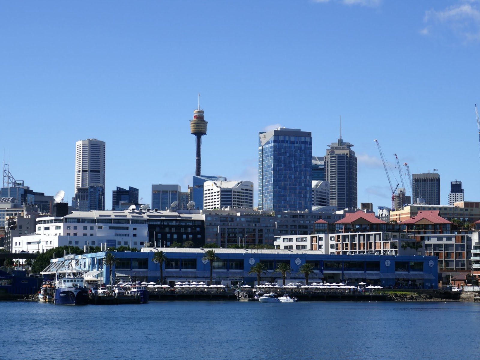
Along the Sydney skyline, from left to right, you can see Sydney Tower at Market Street; the World Square Tower at Liverpool Street; the Market Tower over Paddy’s Market; and the University of Technology Tower in Broadway.
 |
| Sydney's skyline |
The path leads along the foreshore, passing the site of the old Sydney incinerator (now apartments) to reach Bridge Road. On the opposite side of the road is Wentworth Park, created from Blackwattle Swamp in 1880-82 and named after the Father of Representative Government in NSW, W.C. Wentworth. It predated Centennial Park and was once elaborately landscaped. Now, it is mainly used for social sports.
 |
| The Sydney Fish Markets |
We followed Bridge Road to enter Sydney Fish Market, which has operated on this site since 1966. The large blue building was once the Australian Paper Mill warehouse but was taken over for the wholesale auction and to house more retail outlets. We wound around the outside of the main market hall and the car park to the dark underpasses below the Western Distributor, one of Sydney's arterial motorways. At the end of Saunders Street is the sweeping path up to the Anzac Bridge.
 |
| The curving path up to Anzac Bridge |
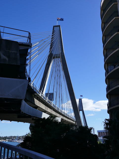 |
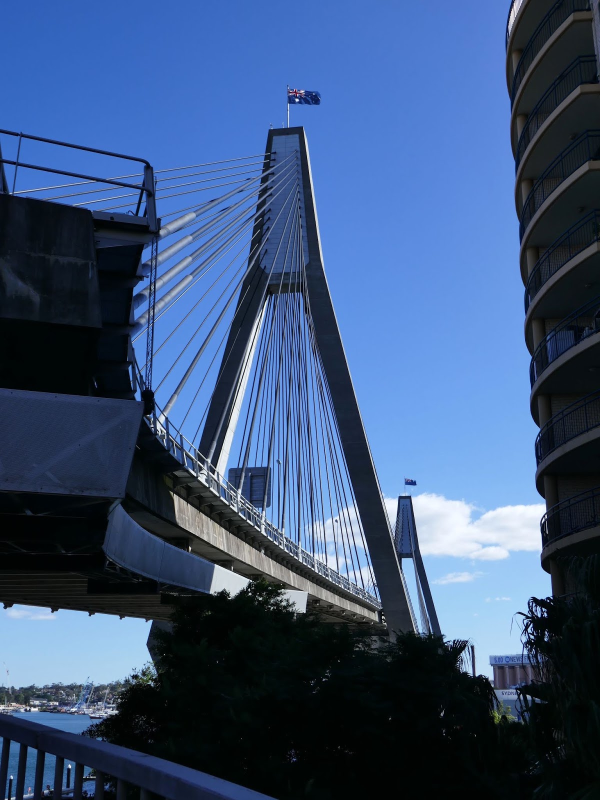
| Anzac Bridge |
There is a combined bike and footpath on the north side of the bridge, though the scenery leaves a little bit to be desired. Johnstons Bay is one of Sydney's cruise ship ports and consists of little more than a series of ugly concrete docks. The Anzac Bridge is a fairly modern structure, opened to traffic on 3 December 1995 as the Glebe Island Bridge.
 |
| Anzac Bridge |
 |
| The huge supporting pylons |
The bridge was given its current name on Remembrance Day in 1998 to honour the memory of the soldiers of the Australian and New Zealand Army Corps (the Anzacs) who served in World War I. An Australian flag flies atop the eastern pylon, and a New Zealand flag flies atop the western pylon. A bronze memorial statue of an Australian Anzac soldier ("digger") holding a Lee–Enfield rifle in the "rest on arms reverse" drill position was placed on the western end of the bridge on Anzac Day in 2000.
 |
| Anzac memorial |
 |
| The memorial and bridge |
The rest of the walk peters out a bit after the ANZAC Bridge. We followed James Craig Drive, which passes the Sydney Boathouse, to the top of Rozelle Bay and the car park where we'd left the car.
 |
| Sydney Boathouse |
 |
| Anzac Bridge once again |
So, not a bad outing considering travel restrictions and its proximity to home, though probably not a walk I'd repeat in a hurry. While the foreshore parks are very pleasant and have fine views of the bays, the areas on either side of the Anzac Bridge leave a bit to be desired in terms of interest. An extension of the walk to include Darling Harbour would be a great addition, and one I may try in the future.


No comments :
Post a Comment