Centennial Glen, Colliers Causeway & Porters Pass 01-03-2025
This map was created using GPS Visualizer's do-it-yourself geographic utilities.
Please wait while the map data loads...
Route: Centennial Glen Road, Walls Ledge Loop Track, The Grotto, Centennial Glen, Slippery Dip Falls, Colliers Causeway, Porters Pass, Lamberts Lookout, Cliff Top Track, Fort Rock, Delaney Reserve
Date: 01/03/2025
From: Centennial Glen Road
Parking: Centennial Glen Road
Start Point: Centennial Glen Car Park
Finish Point: Centennial Glen Car Park
Region: Blue Mountains National Park
Route length: 5.0 km
Time taken: 02:12
Average speed: 3.2 km/h
Ascent: 428m
Descent: 430m
At the headwaters of Centennial Glen Creek is Centennial Glen, a beautiful sandstone gorge that is home to a popular climbing area and one of the area's best short hikes. If you're seeking a bit of adventure, look no further than the Centennial Glen, Colliers Causeway and Porters Pass loop. This short trail boasts a remarkable mix of landscapes along its 6 km length: dramatic cliff lines, verdant rainforests, and a pretty little waterfall nestled within a narrow slot canyon. And, it's dog-friendly too, so Fido can enjoy it as well.
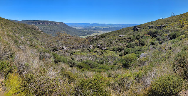
Parking for Centennial Glen is along Centennial Glen Road. While still a lesser-visited trail, there is a popular climbing area nearby, so the road can get busy. A small toilet block stands at the beginning of the man path, with a few others shooting off in different directions. We began with a direct descent towards the glen, however, there is a longer route along the Walls Ledge Loop Track which I'd recommend. There are some fine views of the Kanimbla Valley as you make your way down towards the glen.
 |
| Heading for Centennial Glen |
 |
| There are plenty of signs along the way |
 |
| Decisions, decisions |
 |
| The Kanimbla Valley |
 |
| Above Centennial Glen |
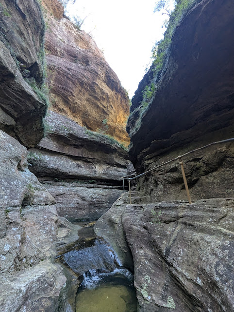
A steep set of metal steps take you into the depths of the glen, meeting a signed path at the bottom. Before continuing the main walk, a short detour leads into a dark slot canyon (The Grotto) with a beautiful little waterfall at the far end. Reaching the waterfall requires a tricky shuffle along a rock shelf with a short, awkward move around an outcrop of rock. It's little exposed, though a fall may lead to little more than getting wet. Conversely, you could walk directly along the creek if you wish.
 |
| Getting to the canyon requires descending some steep steps |
.jpg) |
| The Grotto |
 |
| The Grotto |
 |
| The Grotto — a panorama taken from the rock shelf |
After exploring The Grotto, we returned to the track junction and continued in the direction of Colliers Causeway. The path makes a spectacular descent alongside the lower waterfalls of Centennial Glen Creek – the amusingly named Slippery Dip Falls. The carved stone steps and metal rails get you close to the action as they twist and turn their way to Colliers Causeway.
 |
| Centennial Glen Creek |
 |
| The path squeezes between these large rocks |
 |
| The narrow canyon above Slippery Dip Falls |
 |
| Perfect place for a paddle |
 |
| Time for a swim |
 |
| Centennial Glen Creek |
 |
| At the top of Slippery Dip Falls |
 |
| At the top of Centennial Pass |
 |
| Centennial Glen Creek |
Colliers Causeway is one of the less well-publicised tracks in the Blackheath area of the Blue Mountains and is quite spectacular in its own right. It passes beneath the occasional overhanging cliff or waterfall as it winds along a sequence of ledges and terraces. Though the overall length is quite short, Colliers Causeway possesses a great deal of variety along its length. It's quite rough in places and slower going than you might expect.
 |
| Colliers Causeway |
 |
| Colliers Causeway |
 |
| Colliers Causeway |
 |
| Colliers Causeway |
 |
| The walls of the Kanimbla Valley |
We soon arrived at the base of Porters Pass, one of the oldest tracks in the Blue Mountains, dating back to 1888, though it is probable that Indigenous people pioneered the routes down the western escarpment thousands of years before. Steps, typical of the national park, make a steep climb up the Porters Pass gully. At the top of the gully is Lamberts Lookout (located just off the main track) which has a sweeping view of the valley from one of the many rock outcrops.
 |
| The beginning of Porters Pass |
 |
| Lamberts Lookout |
 |
| Porters Pass |
 |
| The top of Porters Pass |
From the top of the pass, the route climbs a little further before dropping again, crossing an open expanse of hillside with wonderful views across the Megalong and Kanimbla Valleys. This is the Cliff Top Track and which leads to Fort Rock, a large, isolated rock at a junction of several other paths.
 |
| Cliff Top Track |
 |
| Kanimbla Valley |
 |
| Cliif Top Track |
 |
| Fort Rock |
Shortly after Fort Rock is another junction in the track. The right hand fork (which actually turns back on itslef) delves back down into Centennial Glen and involves losing some of your hard-earned elevation. Otherwise, staying the course will take you to Delaney Reserve and a small waterfall on Centennial Glen Creek - perfect some more doggy splashing around.
 |
| Sugarloaf Mountain in the distance |
 |
| Kanimbla Valley views |
.jpg) |
| Cooling off some hot paws in Centennial Glen Creek |
From the creek, it's a fairly easy 700m back to the car park, following a path that cuts across the hillside below Ambo Street, emerging back at the toilet block I mentioned earlier.
Centennial Glen is a highly recommended hike, particularly if you're after a less touristy experience. It provides an exceptional combination of traditional Blue Mountains characteristics, such as rainforest gullies, escarpments, and open heathland. While not as well-known as some other popular hikes, Centennial Glen/Porters Pass area is a favourite among those who have tackled it.


.jpg)


.jpg)


No comments :
Post a Comment