Mt. Kosciuszko & Rams Head 23-12-2023
This map was created using GPS Visualizer's do-it-yourself geographic utilities.
Please wait while the map data loads...
Route: Dead Horse Gap, Bogong Creek, Dead Horse Gap Walking Track, The Basin Top Station, Kosciuszko Walk, Merritts Creek, Kosciuszko Lookout, Snowy River, Etheridge Gap, Lake Cootapatamba Lookout, Etheridge Ridge, Rawson Pass, Mount Kosciuszko, Rawson Pass, Etheridge Gap, Snowy River, Rams Head North, Rams Head, Rams Head South, Dead Horse Gap
Date: 23/12/2023
From: Dead Horse Gap
Parking: Dead Horse Gap
Start Point: Dead Horse Gap
Finish Point: Dead Horse Gap
Region: Kosciuszko National Park
Route length: 23.9km
Time taken: 08:00
Average speed: 3.8km/h
Ascent: 1175m
Descent: 1173m
Points of Interest: Kosciuszko Lookout, Lake Cootapatamba, Etheridge Ridge, Mount Kosciuszko, Rams Head North, Rams Head South
After a one-year hiatus, I returned to the high country of Kosciuszko National Park. When we moved to Australia, I was thrilled to discover that the country’s highest mountains are located in New South Wales, in the Snowy-Monaro region—a not-unreasonable five-hour drive from Sydney. This area is home to the Australian Alps, the highest mountain range in Australia, which forms the backbone of the Great Dividing Range, stretching 3,000 km from northern Queensland to northern Victoria.
Within the Australian Alps are the Snowy Mountains (The Snowies), home to the five highest peaks on the Australian mainland, all exceeding 2,100 m. Mount Kosciuszko (pronounced Koz-ee-os-koh) is the tallest at 2,228 m. Until 1977, it was possible to drive almost to the summit. Today, hiking to the top of Australia’s highest peak is considered the easiest of the Seven Summits and achievable by most with a moderate level of fitness.
Having completed the Main Range hike a few times, I decided to approach Mount Kosciuszko from a different direction while also crossing the wild Rams Head Range, creating a long and rewarding day in the mountains.
I began my hike bright and early, driving the short distance from the campground at Ngarigo to Dead Horse Gap. The mountain pass is notable as it divides the watershed of the Snowy River and Murray River systems. The reference to dead horses relates to the brumbies (the wild horses that inhabit the area) that sometimes became trapped in this area during unexpected snowfalls and died. A gravel parking area beside the road has space for a few cars.
 |
| Dead Horse Gap |
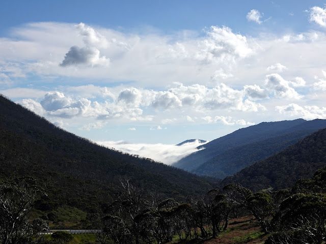 |
| Clouds fill the valley at Thredbo |
My hike started with a descent along the Alpine Way to Bogong Creek and the Dead Horse Gap Walking Track. Park signs provide directions and distance information for both this walk and the Thredbo River Walk, which also starts here.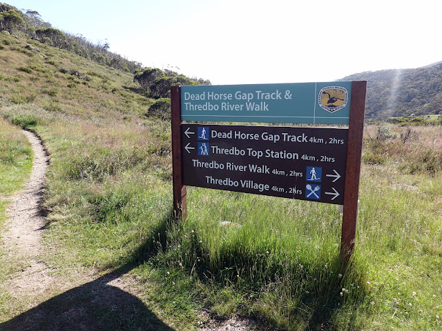 |
| Walking tracks from Bogong Creek |
 |
| Starting the Dead Horse Gap Track |
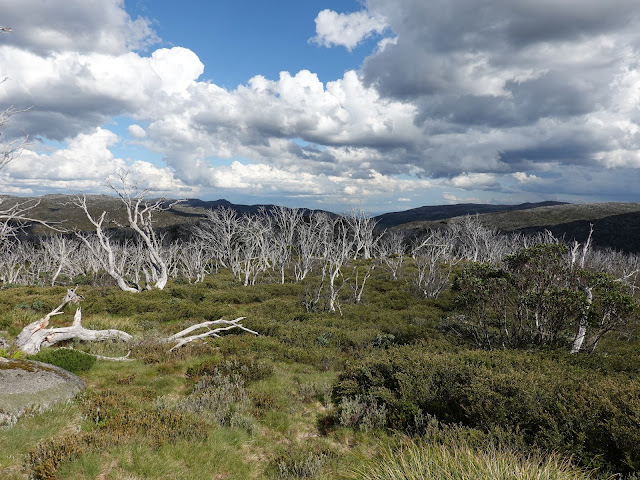
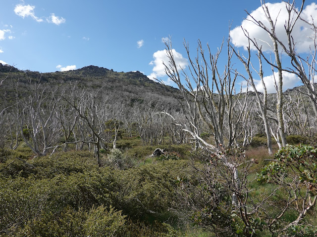
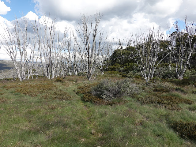
The walking track climbs the wild and remote side of the Rams Head Range. The initial part of the track is the steepest as it climbs through the beautiful snow gums to the tree line, often negotiating steeper sections with wooden steps. Once the trees open up there are good views across to the Rams Head mountains where I'd be returning later in the day.
 |
| The beautiful striped snow gums |
 |
| Looking towards Rams Head South |
 |
| Some of the peaks within the range do not have an official name, despite being over 2,000m tall - I have seen this one referred to as Middle Rams Head |
 |
| The trees thin as you approach the higher elevations |
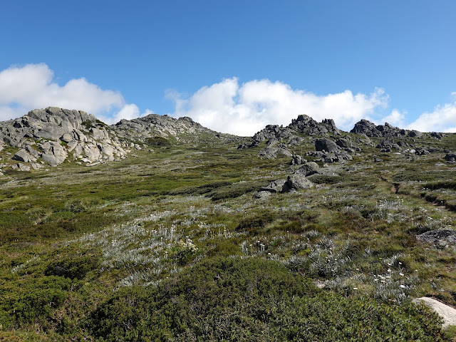
Once through the snow gums forest things start to get a little rockier as the steepness abates. The open grasslands are spectacular with the track passing several rock outcrops as it climbs to the top of the ridge. The ridge has a commanding view down to Eagles Nest, Australia’s highest restaurant. It is easily accessible, nestled on the mountain directly opposite the top of the Kosciuszko Express chairlift, and is open year-round.
 |
| Looking along the natural folds of the Alpine Way |
 |
| The rocky alpine plateau below Rams Head North |
 |
| Rock tors are dotted around the alpine meadows |
 |
| Crossing the crest of the Dead Horse Gap Walking Track |
 |
| Over the crest of the ridge is a fine view of the Thredbo ski fields |
 |
| Eagles Nest |
The path makes its way towards Eagles Nest, passing some of the ski runs that form the Thredbo ski resort (obviously, they do not operate in the summer). That said, the Kozscuisko Express ski lift continues through the summer, providing an easy (but pricey) way of accessing the Kosciuszko Walk, which leads towards the summit of Mount Kosciuszko 7km away.
 |
| Eagles Nest |
 |
| The metal-plated Kosciusko Walk at Merritts Creek |
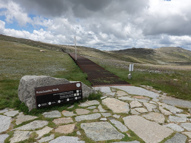
The summit trail is one of the most popular in the national park and a metal walkway has been installed along most of its length to protect the fragile alpine environment. This makes the hike to Koszcuisko Lookout and beyond fairly straightforward. Koszcuisko Lookout has a fine view across the headwaters of the Snowy River towards Australia's highest mountain.
 |
| The Kosciusko Walk |
 |
| Looking back towards Eagles Nest |
 |
| Eagles Nest |
 |
| The Kosciuszko Walk with Mount Kosciuszko in the background |
 |
| Views over the source of the Snowy River from Kosciuszko Lookout, The two summits are Mount Kosciuszko (L) and Etheridge Ridge (R) |
The metal walkway continues, crossing the infant Snowy River and Etheridge Gap before arriving at Lake Cootapatamba Lookout. The Lookout has a fine view of Lake Cootapatamba, the highest-elevation lake in Australia. It is one of only five glacial lakes on the Australian mainland, making it very special. The lake is backed by a view of Mount Kosciuszko.
 |
| Mount Kosciuszko |
 |
| Lake Cootapatamba |
 |
| Rawson Pass |
A short distance after the lookout I left the main track to climb Etheridge Ridge, one of the main named summits that form the Australian 200m peaks. It is fifth on my list with a summit elevation of 2,188m. The climb to the top is straightforward and affords fine views across the area.
 |
| Etheridge Ridge |
 |
| The summit of Etheridge Ridge lies atop a pile of rock |
 |
| Rawson Pass and Mount Kosciuszko from the summit of Etheridge Ridge |
 |
| Views over the Main Range - Australia's highest peaks |
The descent from Etheridge Ridge leads directly to Rawson Pass where the old Kosciuszko Road, from Charlotte Pass, meets the metal walkway from Thredbo. It is home to the highest public toilet in Australia. It marks the beginning of the final climb to Mount Kosciuszko.
 |
| Rawson Pass |
Rather than heading directly for the top, the final section of the track loops around the west of the summit before turning back on itself for the final few metres of climbing to the trig pillar. From 2,228m above sea level, the views across the Main Range are sensational.
 |
| The final gravel track to the summit |
 |
| A trig pillar marks the top of Australia |
 |
| There is a fine panorama of the highest land in the country |
Mount Kosciuszko (or to give its Aboriginal name, Jagungal) was given its European name by Polish explorer Pawel Strzelecki in 1840, in honour of freedom fighter General Tadeusz Kościuszko because of its perceived resemblance to the Kościuszko Mound in Kraków, Poland.
 |
| The Western view from Mount Kosciuszko |
 |
| Looking along the Snowy River towards Charlotte Pass |
 |
| Mount Townsend looms in the distance |
I returned from the summit to Rawson Pass and took a break before planning the next leg of this hike; crossing the Rams Head Range. This would involve backtracking to the Snowy River, and then climbing the gentle, pathless slopes below Rams Head North. The springs of the Snowy River would also allow me a full refill of my water bottles in preparation for the next few kilometres.
 |
| Etheridge Ridge and Rawson Pass |
 |
| Back at Rawson Pass |
 |
| Panorama from the Lake Cootapatamba Lookout |
Crossing the Rams Head Range is quite different to the hike up Mount Kosciuszko, mainly because much of it is off-track, except for a few vague paths here and there. You'll unlikely see any other hikers along the route, so you should be prepared accordingly - think packing a PLB for instance. While the area has several rocky peaks I was content just hiking the named ones. First up; Rams Head North.
 |
| Approaching Rams Head North |
Rams Head North is located just off the main Kosciuszko Walk track and is topped by a pyramid of broken rock which is taller than it first appears. I found the easiest way to the summit was from the southeast but the jumbled rocks offer more technical scrambles if you so wish.
 |
| Rams Head North |
 |
| Pick your own adventure to get to the summit |
 |
| Interesting rock formations surround Rams Head North |
As I sat out a passing shower on Rams Head North, I contemplated the route ahead which appears more challenging in person than on paper, largely because the hills look much bigger in reality than they do as contours on the map. First, I'd have to cross the marshy Merrits Creek then ascend another 50m to gain the ridge that leads to Rams Head.
 |
| The route continues towards the higher peak to the centre of this image |
 |
| Showers loom |
Two unnamed peaks separate Rams Head North from Rams Head, the tallest of the immediate mountains at 2191m. The unnamed peaks can be easily bypassed and hiking is easy once you gain the main ridge above Merritts Creek. Climbing Rams Head is also straightforward and gets you to the top of the fourth-highest peak in Australia.
 |
| Passing showers |
 |
| Rams Head - the tallest of the group - is the next objective |
 |
| Rams Head |
 |
| The summit of Rams Head |
 |
| Mount Kosciusko's South Ridge |
 |
| Mount Kosciusko and Lake Cootapatamba |
The view of the remaining hike is visible from the summit of Rams Head, leading along a broad ridge towards South Rams Head. While I picked my way down the slope from Rams Head, I happened across a faint path blazing a trail in the direction I needed to go. Clearly made by hikers before me, the path (of sorts) made the crossing to Rams Head South fairly benign, however, the combination of alpine vegetation and mossy bogs shouldn't be underestimated. Climbing to the summit of South Rams Head involves a bit more route-finding to avoid the worst of the bushes and trees that guard the approaches.
 |
| The route heads almost directly towards Rams Head South, the further of the two peaks shown here |
 |
| The unnamed peak between Rams Head and Rams Head South |
 |
| Looking back at Rams Head |
 |
| Further down in the valley below Rams Head |
 |
| The crossing towards Rams Head South |
 |
| Rams Head South |
 |
| The Rams Head Range seen from South Rams Head |
 |
| The summit of Rams Head South is well defended by rocks and bushes |
 |
| The western slopes of Mount Kosciuszko |
 |
| The summit is home to a metal trig station |
With Rams Head South in the bag (at least the tallest peak to the south of the range) it was time to set my sights back on Dead Horse Gap, some 500m directly below me. A south-easterly route leads from the summit towards the tree line where a well-disguised trail begins at around the 1920m contour (you may notice some small cairns on the way down, leading to the top of the trail). The trail makes it much easier to wind a course through the trees and down the hillside towards Dead Horse Gap.
 |
| Looking back towards Rams Head |
 |
| The route back towards Dead Horse Gap is marked out by a series of small cairns |
 |
| Afternoon showers |
 |
| Descending from Rams Head South |
 |
| The view back to Rams Head South |
 |
| The path is little more than a faint trail through the trees but makes all the difference |
Keep a firm eye on the trail through the trees as it can frequently become lost among the trees and vegetation. There were a handful of occasions when I had to pause to take a look around before spotting the continuation. The prospect of descending the slope without the path is not appealing. Eventually, the path emerges at the Alpine Way, opposite the gravel parking area at Dead Horse Gap. Thankfully, the car was exactly where I had left it at the beginning of the day.


No comments :
Post a Comment