Hooker Valley Track 22-03-2023
This map was created using GPS Visualizer's do-it-yourself geographic utilities.
Please wait while the map data loads...
Route: White Horse Hill Campground, Hooker Valley Track, Lower Hooker Suspension Bridge, Hooker Bluff Suspension Bridge, Stocking Stream, Upper Hooker Suspension Bridge, Hooker Lake
Date: 22/03/2023
From: White Horse Hill
Parking: White Horse Hill
Start Point: White Horse Hill Campground
Finish Point: Hooker Lake
Region: Aoraki / Mout Cook National Park
Route length: 11.4km
Time taken: 04:55
Average speed: 4.7km/h
Ascent:271m
Descent: 271m
Points of Interest: Mueller Lake Lookout, Alpine Memorial, Hooker Lake
Aoraki / Mount Cook National Park lies at the heart of New Zealand's South Island (Te Waipounamu). As its name suggests, it is home to Aoraki / Mount Cook, the tallest mountain in the Southern Alps and New Zealand's highest peak. The national park is Alpine in the truest sense and is home to over 140 mountains over 2,000m and 72 named glaciers that cover 40% of the total area of the park.
Aoraki / Mount Cook is the star attraction and, despite standing at a lofty height of 3,724m, hikers can get surprisingly close to the mountain thanks to the unique geography of the Southern Alps and the many valleys and lakes that radiate away from the high mountains. There is no better way to see Aoraki / Mount Cook than the Hooker Valley Track, arguably one of the best short walks in New Zealand, if not the world.
The hike begins from a large car park at the White Horse Hill campground, marking the starting point of the Hooker Valley Track. Other popular hikes that depart from White Horse Hill include the Mueller Hut Route, Sealy Tarns Track and the Kea Point Track so it makes a good base to explore a small part of Aoraki / Mount Cook National Park.
We were fortunate to have stayed the night in the campground meaning we could get an early start and not have to worry about the car park filling up. We had arrived under a dreary grey sky the evening before but had high hopes for the day ahead, hopes that were confirmed after a glance out of the window of our campervan just after sunrise.
 |
| Lake Pukaki on the drive to Aoraki / Mount Cook - the mountain is hidden among the clouds |
 |
| The Huddleston Glacier on Mount Sefton, hidden within the clouds |
 |
| Morning sun on Mount Sefton |
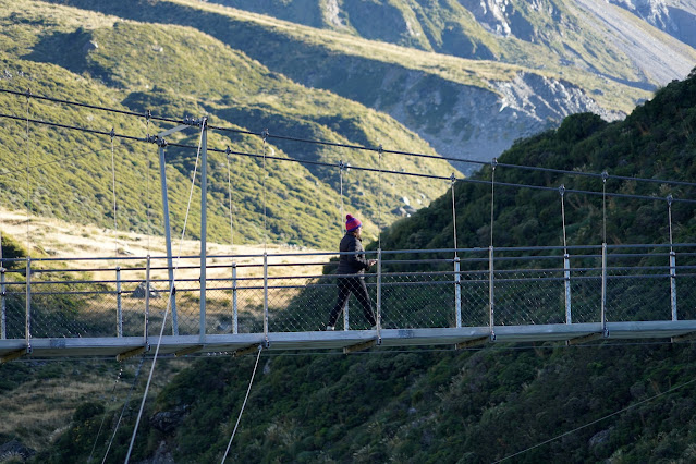
After seeing the clearness of the skies, we hastily got ready and set out along the tHooker Valley Track where there are some fleeting glimpses of Aoraki / Mount Cook before it is obscured by the slopes of Mount Wakefield. The mountain was clear so we were keen to make inroads along the track, bypassing the Alpine Memorial and making our way to the first of three suspension bridges that cross the Hooker River. Above the first bridge (Lower Hooker Suspension Bridge) is the Mueller Lake Lookout with views across Mueller Lake.
 |
| An overnight dump of snow would make things look even more impressive |
 |
| The Tasman River valley |
 |
| The Hooker Valley - Aoraki / Mount Cook can just be seen |
 |
| The first swing bridge over Hooker River |
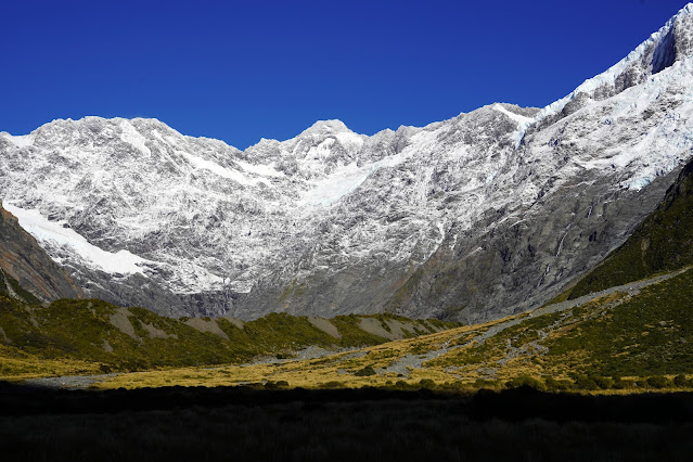
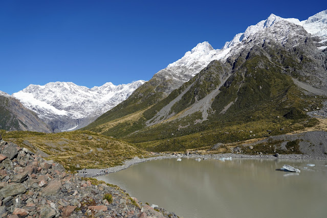
The large lake is fed by the Mueller Glacier which drains the eastern side of Mount Sefton, Mount Thompson and Mount Isabel, absorbing the Frind and Huddlestone Glaciers along the way before terminating at the lake. By dating the lichen on the surrounding rocks, it is estimated that the glacier had its maximum mass in the 1720s. Since then, it has been retreating - the lakes only started to appear in the 1970s and scientists have recorded a 2.5km retreat between 2000 and today. Sadly, this is a story you'll hear right across New Zealand.
 |
| Mount Sefton and Mueller Lake |
 |
| Mount Sefton and the Tuckett and Huddleston Glaciers |
As it was early, the low sun made taking photos a little tricky thanks to the stark contrast between the bright snow and shadowy valley, however, I can have no complaints about the weather. Once across the first bridge, we continued along the track as it follows the shores of Mueller Lake.
 |
| Crossing the first bridge over Hooker River |
 |
| Hooker River |
 |
| Mueller Lake and Mount Sefton |
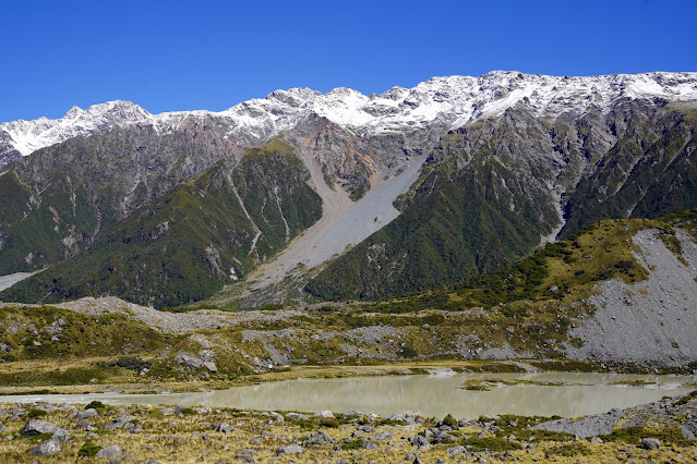
The second suspension bridge (Hooker Bluff Bridge) crosses Hooker River where the river is forced through a gap between the slopes of Mount Wakefield and the old terminal moraine of the Hooker Glacier with Mount Sefton dominating the view ahead. You'll often see this view used in guides for the Hooker Valley Track. Before long, the magnificent Aoraki / Mount Cook comes into view.
 |
| Mueller Lake and the Sealy Range |
 |
| The second bridge |
 |
| Crossing the second bridge |
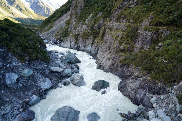 |
| The Hooker River where it carves a path through the moraine |
 |
| Once across the second bridge Aoraki / Mount Cook comes into view |
 |
| Aoraki / Mount Cook |
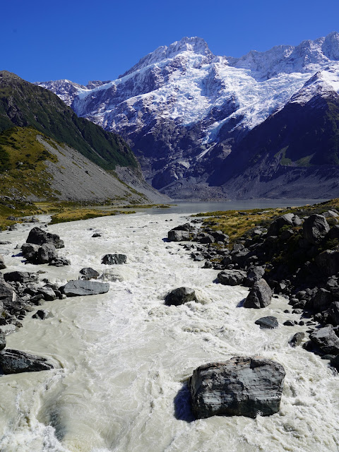
There is a small block of toilets alongside the track heading towards Aoraki / Mount Cook and it's worth stopping if you plan to spend a bit of time around Hooker Lake. The valley track, now on a boardwalk, follows the river up the broad Hooker Valley to the third suspension bridge (Upper Hooker Bridge) where it crosses Hooker River once again. The trail passes a small tarn before a modest climb to Hooker Lake.
 |
| Hooker River |
 |
| The Tewaewae Glacier below The Footstool |
 |
| Aoraki / Mount Cook |
 |
| The boardwalk along the Hooker Valley |
 |
| Mount Thomson and the peaks above Mueller Lake |
 |
| Mount Sefton and The Footstool |
 |
| The last crossing of the Hooker River |
 |
| Sara crossing the last swing bridge |
 |
| Hooker River |
 |
| Hooker Lake and Aoraki / Mount Cook |
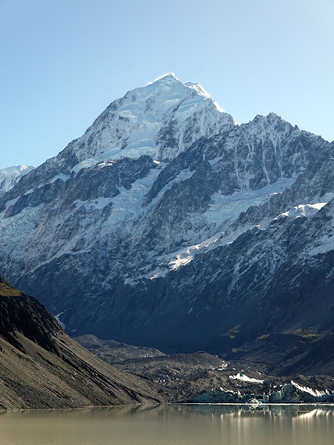
We were rewarded with the sensational view of Aoraki / Mount Cook rising above the far end of the lake. We were incredibly lucky with the weather - Aoraki / Mount Cook can receive up to 10,000mm of rain annually and is hidden in the clouds over 200 days of the year.
No such problem today.
From the vantage point at Hooker Lake, the summit of Aoraki / Mount Cook is only 10km away (and nearly 3km higher).
 |
| Hooker Lake as the sun continues to rise |
 |
| The Aroarokaehe Range above Hooker Lake |
Since the 1998 Ngāi Tahu Claims Settlement Act, many significant places in New Zealand now officially bear two names; the European name and the Māori name and should be referenced using both, as I have tried to do so here.
 |
| Aoraki / Mount Cook |
In Māori legend, Aoraki was a young boy who, along with his three brothers, were the sons of Rakinui, the Sky Father. On their voyage around the Papatūānuku, the Earth Mother, their canoe became stranded on a reef and tilted. Aoraki and his brothers climbed onto the top side of their canoe. However, the south wind froze them and turned them to stone. Their canoe became the Te Waka o Aoraki, the South Island, and their prows, the Marlborough Sounds. Aoraki, the tallest, became the highest peak, and his brothers created the Kā Tiritiri o te Moana, the Southern Alps. Of all the places in New Zealand (Aotearoa) that have a shared name, Aoraki / Mount Cook is the only one where the Māori precedes the English name.
 |
| Hooker Lake - the colour comes from the immense quantities of glacial 'flour' - fine sediments washed down from the Hooker Glacier |
 |
| Eugenie Glacier |
 |
| The southern end of Hooker Lake |
Aoraki / Mount Cook is geologically active thanks to its location on the Alpine Fault that runs up the spine of South Island. Continued uplift increases its height by up to 7mm each year, however, the mountain is subjected to immense erosive forces as it juts into the Roaring Forties, the powerful westerly winds that blow around the 45°S latitude. The Southern Alps are the first obstacle these winds encounter after leaving South America.
 |
| Mt Hicks and the top of the Hooker Glacier |
As a result, the peak of Aoraki / Mount Cook has suffered notable collapses; one in 1991 where 10m of the peak fell and a further 30m were lost due to the continued erosion of the exposed ice cap.
 |
| The windswept summit of Aoraki / Mount Cook - Low Peak (3,593m) in the foreground at the top of Hillary Ridge and High Peak (3,724m) at the back |
As we had no plans for the day, we spent a good amount of time watching the unfolding scene as the sun rose above the line of mountains that ring Hooker Lake. You'll find venturing away from the lookout platform will reward you with a quiet spot to soak up the views and we were lucky to witness one of the icebergs rolling over in the lake once the sun had started to melt them.
 |
| The moraine at the end of Hooker Lake |
 |
| Nazomi, Hillary Ridge and Aoraki / Mount Cook |
 |
| The face of the Hooker Glacier |
 |
| The shores of Hooker Lake show where the glacier once stood |
 |
| Iceberg in Hooker Lake |
 |
| Cadogan Peak, Eugenie Glacier and Eugenie Stream |
Eventually, we set off the explore a little more of Hooker Lake, following the rocky shoreline south to the Hooker River. We got some of the most impressive views of Aoraki / Mount Cook from here, framed by the icebergs in the lake.
 |
| Hooker Lake |
 |
| Aoraki / Mount Cook |
 |
| Hooker Lake |
 |
| Icebergs in Hooker Lake |
 |
| Cadogan Peak |
As it approached midday, we finally managed to tear ourselves away from the lake and start making tracks back towards the campground. Having been able to revel in the views around Hooker Lake, we now had ample time to stop by the alpine tarn, Mueller Lake Lookout and Alpine Memorial on the way back.
 |
| The shores of Hooker Lake |
 |
| Hooker Valley looking towards the old glacial terminal moraine |
 |
| The alpine tarn |
 |
| The third suspension bridge |
 |
| Stocking Stream |
 |
| Hooker River and Aoraki / Mount Cook |
 |
| The second swing bridge |
 |
| Tasman River valley |
 |
| Mueller Lake and Mount Sefton |
 |
| Mount Sefton |
 |
| The Sealy Range |
 |
| Hooker River |
 |
| Mueller Lake |
 |
| The first swing bridge |
 |
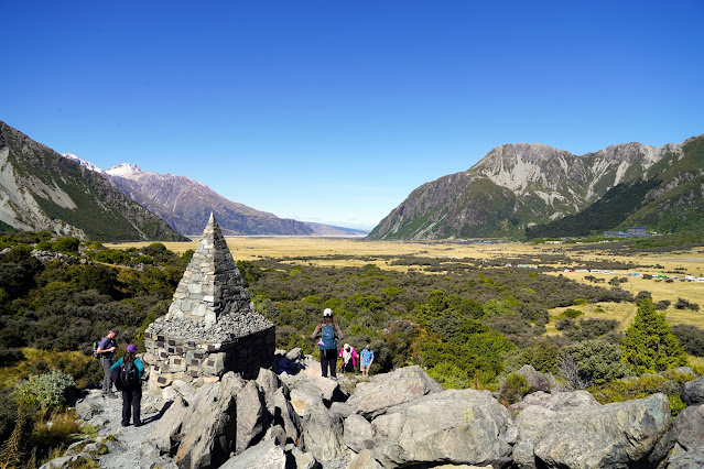
| The Alpine Memorial |
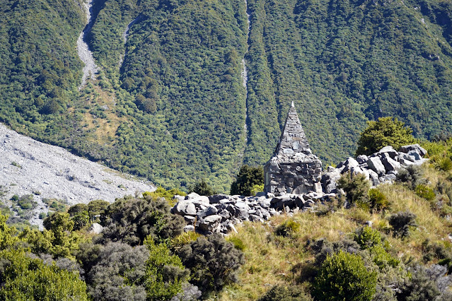
The Alpine Memorial is dedicated "to the memory of mountaineers and guides lost to the hills". Aoraki / Mount Cook is New Zealand's deadliest peak, having claimed over 80 lives in the C20th. It is a technically challenging mountain with the first known ascent in 1894. Sir Edmund Hillary first climbed the mountain in 1948 before going on to becoming the first climber to summit Mount Everest with Sherpa mountaineer Tenzing Norgay in 1953.
 |
| The Alpine Memorial |
 |
| Aoraki / Mount Cook as seen from the memorial |
 |
| The memorial has a commanding view |
By the time we returned to the campground the car park and adjoining roads were full of cars and visitors taking advantage of the stunning weather. While you may think our adventure in Aoraki / Mount Cook National Park ends here, you'd be wrong. The adjacent valley is home to the Tasman Glacier which sports a lookout atop the old terminal moraine. It takes around 5 minutes to drive to the car park where a 90m climb to the lookout beckons. Truth be told, the climb to Tasman Glacier lookout is more taxing than anything on the Hooker Valley Track, which is very straightforward.
The views from the lookout are sensational.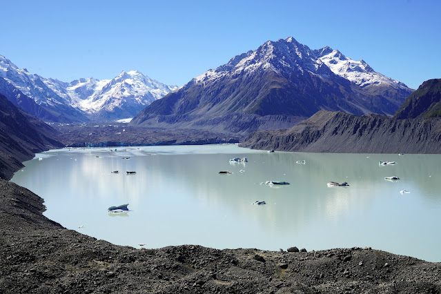 |
| Tasman Lake |
Tasman Glacier / Huapapa is the largest of New Zealand's glaciers, stretching for 23km from Hochstetter Dome to Tasman Lake. It is currently 4km wide and over 600m thick though has been shrinking rapidly since the 1990s. Many people miss the glacier as it is not the pristine white sheet of ice people expect to find - the lower few kilometres are covered in a layer of grey rock debris that somewhat camouflages the glacier.
 |
| The immense Tasman Glacier / Huapapa |
 |
| Tasman Lake |
 |
| Tasman River |
 |
| A boat trip onto the lake is a popular tourist attraction |
 |
| The Tasman River flowing towards Lake Pukaki |
The view is dominated by Novara Peak (part of the Malte Brun Range) while the very tip of Aoraki / Mount Cook can be seen peaking above Ball Ridge. Along the length of Tasman Lake is the Liebig Range, home to mountains such as The Acolyte and Nun's Veil.
 |
| Middle Peak (3,717m) and High Peak (3,724m) on Aoraki / Mount Cook |
 |
| Minarets (3,031m / 3,040m) and the De La Beche Ridge dominate the lake |
 |
| Tasman Lake |
 |
| Tasman River |
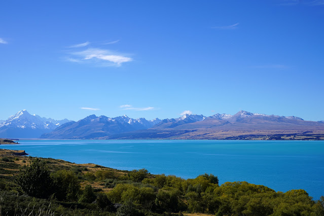
After an epic morning exploring the Hooker Valley and Tasman Glacier, we finally set off in the direction of our next overnight destination in Tekapo, taking us along State Highway 80 - Mount Cook Road. The road follows the luminous blue Lake Pukaki which is fed by water from the Tasman and Hooker Glaciers and has some amazing views of the lake and Aoraki / Mount Cook. Somehow the mountain looks bigger from here than it does from Hooker Lake - amazing what a bit of perspective can do.
 |
| Mount Low and Aoraki / Mount Cook |
 |
| The Gamack Range over Lake Pukaki |
 |
| Lake Pukaki |
 |
| Aoraki / Mount Cook from Peter's Lookout |
 |
| Lake Pukaki |
 |
| Lake Pukaki |
During our month in New Zealand, this was one of the most enjoyable days of the entire trip, especially as the weather had looked very unfavourable at one point. If you get to visit Aoraki / Mount Cook, try your best to find a clear day as the scenery is nothing short of jaw-dropping. February is one of the driest months but you may also be rewarded with dry spells through the winter. The Hooker Valley Track is rightly regarded as one of the world's best short hikes.
 |
| The sun sets on a remarkable day |


No comments :
Post a Comment