Experience the best of Sydney's Northern Beaches on this spectacular coastal trek from Newport to Palm Beach. This stunning route tracks directly across the golden sands of Newport, Bilgola, Avalon, and Whale Beaches. Along the way, you will conquer the steep stairs of Bangalley Head—the highest point on the Northern Beaches—before finishing with a climb up the historic Smugglers Track to Barrenjoey Lighthouse for unmatched views over Pittwater.
Newport Beach to Palm Beach & Barrenjoey Lighthouse
📍 SYDNEY / KU-RING-GAI CHASE NATIONAL PARK
Distance
15.2 km
Duration
03:46 hrs
Elev Gain
+465 m
Elev Lost
-467 m
| Date |
16 January 2022 |
| Starting Point |
Newport Beach |
| Difficulty |
Moderate / hard |
| Pace / Gear |
4.6 km/h — Full day pack |
| Highlights |
Newport Beach, Bilgola Beach, Avalon Beach, Bangalley Headland, Palm Beach, Barrenjoey Lighthouse |
🗺️ Interactive Route Map
Pinch or use wheel to zoom
I've been spending some time hiking along Sydney's coastline, a route that includes the recent Bondi to Manly Walk. After completing the Bondi to Manly Walk over several shorter hikes, I decided to extend that philosophy north and south to the extremities of Greater Sydney. The result has been numerous hikes along the Northern Beaches coastline in the direction of Barrenjoey Lighthouse, with this being the last piece of the jigsaw.
My previous hike saw me reach Newport Beach, having hiked from Collaroy Beach in the south, so, unsurprisingly, Newport Beach is where this hike begins. After leaving the car on a side street, I made my way down to Bert Payne Park to make a start.
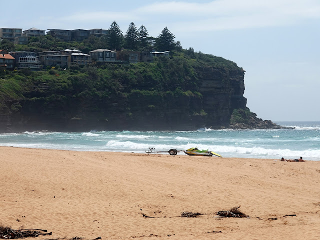
The park lies near the centre of Newport Beach, so I continued down to the surf and walked along the firm, wet sand next to the sea, keeping a watchful eye for any large, rogue waves. At the northern end of the beach are a concrete path and a set of steps that climb up to Bilgola Headland and a viewing platform. If you are wondering why there are so few people enjoying the beach, that's because there was a tsunami warning on this particular day and the beaches were essentially closed.
 |
| Newport Beach |
 |
| Newport Beach |
 |
| Newport Beach |
 |
| If you don't want to hike along the sand, there is a concrete path along the rear of the beach |
The path makes its way across the headland before a steep descent to Bilgola Beach and the small car park next to the Surf Lifesaving Club. A short walk along the shifting sands leads to a set of wooden steps leading away from the beach and on to The Serpentine, a snaking road befitting of its name. At the eastern end of the road is the Bilgola Head Lookout where there is a view southwards to Long Reef, some 10 km away, almost lost among the haze.
 |
| The Bilgola Headland track |
 |
| Bilgola Beach |
 |
| Bilgola Head |
 |
| North Bilgola Lookout |
 |
| Avalon Head |
The Serpentine leads around to Barrenjoey Road, the main route between Palm Beach and the main Northern Beaches suburbs. After a short section walking alongside the road, Surfside Venue cuts between some houses to Avalon Beach.
 |
| The Serpentine |
 |
| Avalon Beach |
 |
| Avalon Beach |
As with the previous beaches, I made my way along the firm sand to the northern end. This quiet suburban street climbs the lower slopes of the imposing Bangalley Head.
The headland can be accessed through a small, signposted reserve off Marine Drive that leads into Bangalley Park, a small strip of grass perched atop the cliffs below Bangalley Head.
 |
| The cliffs at Bangalley Park |
The headland is one of the largest bushland reserves on the Northern Beaches coastline and requires a stiff climb up many steps to reach the top, but it is well worth the effort, as it is the highest point in the Northern Beaches area. Several informal lookouts can be found on the top with precipitous views along the coast to the north and the south.
 |
| Bangalley Park and Avalon Head |
 |
| Careel Head, Little Head and Barrenjoey Head |
 |
| Little Head and Barrenjoey Head |
From the lookouts, the path winds through the bush before descending steeply to Whale Beach Road. The coastline is inaccessible here, and it's over 1 km before I reach it again at Whale Beach itself.
 |
| The path along Bangalley Head |
 |
| There is a steep set of steps on the north side of Bangalley Head |
After following the 600m-long beach, another set of steep steps climbs back to the road, and it's another 1.5 km along the road to reach a narrow cut-through between some houses that leads to the southern end of Palm Beach, arguably one of the finest beaches in the Sydney area.
 |
| Whale Beach |
 |
| Little Head |
 |
| Careel Head and Bangalley Head |
 |
| Palm Beach rock pool |
 |
| Palm Beach |
Aussie soap fans may recognise Palm Beach as the exterior setting for Home & Away. The beach is a tombolo, a landform in which an island becomes attached to the mainland by a narrow piece of land such as a spit or bar. Once attached, the island is then known as a tied island. In this case, Palm Beach is the spit and Barrenjoey Head is the tied island.
 |
| Barrenjoey Headland |
I followed Palm Beach north until I reached Governor Phillip Park, named after Admiral Arthur Phillip, the first Governor of New South Wales, who founded the British penal colony that later became the city of Sydney. Pittwater was the first place in Australia formally named by Governor Phillip in honour of William Pitt, then Prime Minister of England.
 |
| Governor Phillip Park |
 |
| Pittwater and West Head |
 |
| Station Beach |
On the opposite side of Palm Beach is Station Beach, which leads into the Ku-ring-gai Chase National Park, where the path divides. While both options climb to the Barrenjoey Lighthouse, one consists of a series of steep steps (the Smugglers Track) and one a longer, more gradual 4×4 track (the Barrenjoey Lighthouse Track, though it is still steep in places). I opted for the latter, taking the track that winds up through the bush onto the headland (the Smugglers Track is the best option for descent). Clearings in the trees revealed a superb view of Palm Beach.
 |
| Accessing the Lighthouse Track |
 |
| The Lighthouse Track |
 |
| Pittwater |
 |
| Barrenjoey Lighthouse |
 |
| Barrenjoey and Palm Beach |
Before long, I reached the lighthouse atop the headland. It was completed in 1881 and is located on the most northerly point of Sydney, overlooking Broken Bay and the entrance to Pittwater. Close by is the grave of George Mulhall, the first keeper at the lighthouse, and a short trek beyond are the remains of a Stuart tower — the first such lighthouse on Barrenjoey.
 |
| Barrenjoey Lighthouse |
 |
| The vast Broken Bay |
 |
| The marker for the old Stuart tower |
 |
| Barrenjoey Lighthouse |
 |
| The grave of George Mulhall — the first lighthouse keeper |
I had a wander around the headland before making my way back towards Palm Beach along the Smugglers Track. While its name suggests a more illicit purpose, the Smugglers Track was actually built by customs officers in around 1850 (prior to the lighthouse's construction) to monitor any smugglers bringing contraband into Broken Bay.
 |
| Palm Beach |
 |
| The Smugglers Track |
After being deposited back on Station Beach, it was time to start making for home — or at least back to Newport Beach to collect the car. Buses frequently run up and down the coast, connecting the northernmost suburbs to either the ferries at Manly or the main trains at Wynyard Station.
The Newport to Palm Beach walk is a fantastic coastal challenge, seamlessly mixing pristine surf beaches with dramatic clifftop panoramas. Passing through iconic lookouts and Home & Away backdrops before hitting the historic heights of Barrenjoey Lighthouse is an unbeatable way to experience Sydney's northern edge.


No comments :
Post a Comment