Mt. Kosciuszko via the Main Range Track 04-01-2022
This map was created using GPS Visualizer's do-it-yourself geographic utilities.
Please wait while the map data loads...
Route: Charlotte Pass, Main Range Track, Snowy River, Blue Lake Lookout, Carruthers Peak, Mount Lee, Northcote Pass, Muellers Pass, Mount Kosciuszko, Kosciuszko Walk, Rawson Pass, Mount Kosciuszko Summit Walk, Seamans Hut, Snowy River, Charlotte Pass
Date: 04/01/2022
From: Charlotte Pass
Parking: Charlotte Pass
Start Point: Charlotte Pass
Finish Point: Charlotte Pass
Region: Kosciuszko National Park
Route length: 22km
Time taken: 07:45
Average speed: 4.2km/h
Ascent: 903m
Descent: 906m
Points of Interest: Blue Lake, Albina Lake, Mount Kosciuszko
When we were planning to move to Australia, I was thrilled to find that the highest mountains were to be found in New South Wales, in the Snowy-Monaro region of the state - a not unreasonable five-hour drive from Sydney. The region is home to the Australian Alps which are the highest mountain range in Australia, straddling the New South Wales and Victoria border. Here you will find Australia's only peaks which exceed 2,000m in elevation and form the backbone of the Great Dividing Range, an extensive series of hills and mountains that run for 3,000km from northern Queensland to northern Victoria.
Within the Australian Alps are the Snowy Mountains (The Snowies), home to the five highest peaks on the Australian mainland, all of which are over 2,100m. The highest is Mount Kosciuszko (Koz-ee-os-koh), measuring up at a lofty 2,228m. While this sounds impressive, it was possible to drive to within a few metres of the summit until 1977. While not possible now, a hike to the top of Australia is the easiest of all the Seven Summits and can be achieved by most with a moderate level of fitness.
That's not to say that Kosciuszko cannot be made more challenging. While the Summit Track is a straightforward, almost level march from the trailhead to the summit and back, arguably the best route to the summit is the Main Range Track, which traverses a large swath of the High Country before reaching the top of Australia. At 22km, it is the perfect day hike through the highest peaks of the Australian Alps.
The track starts from Charlotte Pass, a snow resort at 1,760m where the public road ends at a trailhead. It is named after Charlotte Adams who was the first European woman to climb Mount Kosciuszko in 1881. Though we arrived early in the morning, we ended up parking part-way along the road, away from the main trailhead.
 |
| The starting point for the Main Range Track |
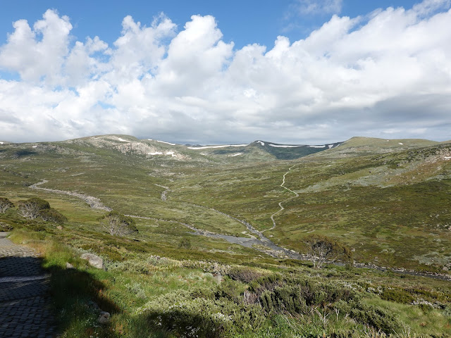
Two trails leave Charlotte Pass, bound for Mount Kosciuszko - the Summit Track and the Main Range Track. The Main Range Track actually descends first before any climbing begins (for this reason, I'd recommend the Main Range Track in an anti-clockwise direction to avoid this climb at the end of a long day).
 |
| There are immediate views of the Main Range as you descend to the Snowy River |
 |
| The Main Range Track climbs after crossing Snowy River |
 |
| Main Range panorama from left to right - Mount Clarke, Mount Northcote, Mount Townsend, Mount Lee, Carruthers Peak and Mount Twynam (Mount Kosciuszko remains hidden for now) |
 |
| The Snowy River valley |
The lowest point of the Main Range Track is the crossing of Snowy River where a series of stepping stones allow you to cross the river without getting wet feet. The Snowy River is one of Australia's major rivers. While its course and surroundings remain largely unchanged, its flow has been drastically reduced after the construction of four large dams which form the backbone of the Snowy Mountains Hydro Scheme, the largest engineering project undertaken in Australia. It took 25 years to construct, being officially opened in 1974.
 |
| Snowy River below Munyang |
 |
| Snowy River |
 |
| Snowy River valley |
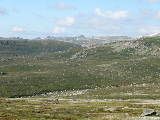
From the river, the Main Range Track begins to climb around the base of a prominent spur. There are extensive views over the Clarke Cirque and the swampy origins of Snowy River though Mount Kosciuszko itself remains hidden for now. The gradient of the track is fairly shallow until it reaches Carruthers Creek where it steepens for a short distance. Here, we crossed the first of several large snowdrifts which often persist long into the summer.
 |
| Mount Clarke and Mount Northcote |
 |
| A distant Rams Head |
 |
| Hedley Tarn |
 |
| Carpets of summer wildflowers |
 |
| The Main Range Track as it approaches Carruthers Creek |
 |
| Carruthers Creek |
 |
| Snow drifts persist into the summer |
At the top of the steeper climb from Carruthers Creek, the track reaches a junction above the Blue Lake, the best example of a cirque lake in Australia, surrounded by the craggy cliffs of Mount Twynam. While unique in Australia, it is very reminiscent of the many lakes and tarns of the Lake District, Snowdonia and Scotland.
 |
| Blue Lake below Mount Twynam |
From the lake, the Main Range Track climbs further until it reaches a col with a spectacular view across the steeper northern slopes of the Main Range and over a vast swath of New South Wales. Mount Sentinel, a prominent peak at the end of an arete dominates the foreground - definitely an objective for another time. From the col, the path makes a switchbacking climb to the summit of Carruthers Peak.
 |
| Heading along the Main Range Track |
 |
| Carruthers Peak holds on to some summer snow |
 |
| Mount Sentinel |
 |
| Looking east to Mount Twynam |
 |
| The summit of Carruthers Peak |
The peak was named after the NSW Minister for Lands and Premier, Joseph Carruthers who facilitated the construction of the Summit Road to Mount Kosciuszko. The area around Carruthers Peak is home to some rare windswept feldmark - a plant community characterised by extremes of cold and exposure to wind.
 |
| Looking along the spine of the Main Range |
 |
| Club Lake Cirque |
The Main Range Track crosses the summit of Carruthers Peak before dropping down the other side of the mountain. Here the track changes from stones and gravel to a metal boardwalk, slightly elevated from the ground to protect the plants beneath it.
 |
| The beginning of the metal track at Club Lake Cirque |
 |
| Club Lake Cirque |
 |
| The descending ridge of Mount Townsend |
 |
| The elevated walkway leading from Carruthers Peak |
The track leads to Northcote Pass, a grassy saddle between Clarke Cirque to the east and the dramatic Albina Lake to the west. The next section of the hike is arguably the most impressive. Between Northcote Pass and Mueller's Pass, the path becomes rocky again, etched onto the side of a steep hill above Albina Lake. The opposite is the rocky flank of Muellers Peak and Mount Townsend.
 |
| Heading for Mueller's Pass |
 |
| Albina Lake |
 |
| Mueller's Pass |
 |
| Mount Townsend and Albina Lake |
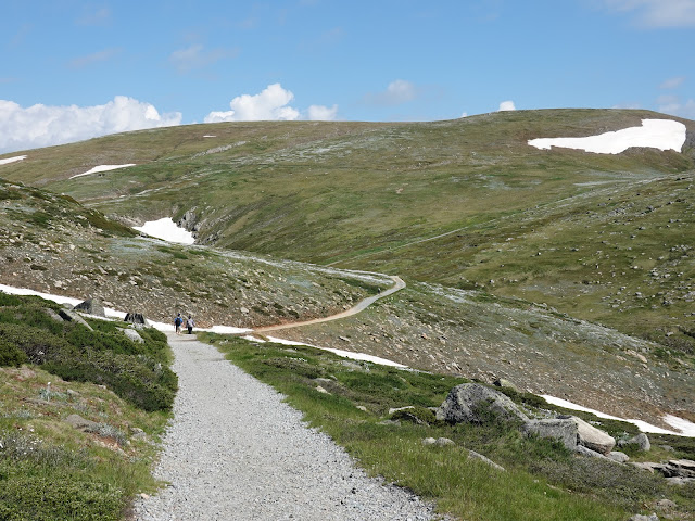
Upon reaching Mueller's Pass, the view really opens up and Mount Kosciuszko finally comes into view though is still a few kilometres of hiking away. There was one final 150m climb to negotiate before we reached the foot of Kosciuszko's summit.
 |
| Heading through Mueller's Pass |
 |
| Seamans Hut on the slopes of Etheridge Ridge |
 |
| Snowy River valley and a distant Charlotte Pass |
 |
| The climb takes place along another engineered track |
 |
| Etheridge Ridge and Rawson Pass |
 |
| The final section before the summit |
Rather than heading directly for the top, the final section of track does a loop around the west of the summit before turning back on itself for the final few metres of climbing to the trig pillar. From 2,228m above sea level, the views across the Main Range are sensational.
 |
| Though the summit is in sight, the path heads around the rear before the final climb |
 |
| Afternoon clouds building |
 |
| The summit of Mount Kosciuszko |
Mount Kosciuszko (or to give its Aboriginal name, Jagungal) was given its European name by Polish explorer Pawel Strzelecki in 1840, in honour of freedom fighter General Tadeusz Kościuszko because of its perceived resemblance to the Kościuszko Mound in Kraków, Poland. On a warm day like today, large crowds were out in force, creating a queue for that all-important summit-selfie.
 |
| The rocky Mount Townsend and Alice Rawson Peak |
 |
| Panorama from Mount Kosciuszko |
 |
| Etheridge Ridge |
 |
| Queues on the summit |
We left the summit behind just as the clouds were starting to build and retraced the loop back to the Main Range Track. The path descends to Rawson Pass, becoming the Summit Walk Track in the process. Rawson Pass is where the old Kosciuszko Road, from Charlotte Pass, meets the metal walkway from Thredbo. It is home to the highest public toilet in Australia. There is also a place to park mountain bikes for those cycling along the old road from Charlotte Pass.
 |
| Afternoon showers |
 |
| Clouds brewing over the slopes of Mount Kosciuszko |
 |
| Mount Kosciuszko |
 |
| The summit track which was once the public road to Rawson Pass |
Now begins the easy bit, a gradual but long descent from Rawson Pass to Charlotte Pass along the old road. The wide track skirts the lower slopes of Etheridge Ridge to Seaman's Hut. The hut was built in 1929 as a memorial to Laurie Seaman, a young skier who perished in a blizzard. The hut was built using money donated by Seaman's parents, for the use of those who might need emergency shelter in the mountains. It is equipped with a wood-burning stove and some modest supplies, though there is precious little wood in the vicinity of the hut.
 |
| Seamans Hut |
 |
| A memorial to lives lost in the mountains |
From Seamans Hut, we followed the track as it descends past the end of Etheridge Ridge. After a short while, the trail crosses a concrete bridge over Snowy River. From here, it's an easy stroll back to the trailhead at Charlotte Pass (though weary legs may make this a long, tedious tramp). The final highlight of the walk is a short passage through the snow gums, the hardy, colourful eucalyptus trees which live in cold areas above 700m.
 |
| Etheridge Ridge |
 |
| Etheridge Ridge |
 |
| Snowy River |
 |
| Mount Twynam and Little Twynam above the Main Range Track |
 |
| Alpine meadows |
 |
| The colourful Snow Gums near Charlotte Pass |
We made it back to Charlotte Pass and the car under a cloudy sky, pretty exhausted but satisfied by an epic mountain day. By now the majority of the parked cars had departed leaving us with a leisurely drive back to Jindabyne, some half an hour away. The Main Range Track is by far the best way to see the highlights of the Australian Alps and, now having gained some familiarity with the area, I'll be back to conquer some more peaks.

Lovely photos and an enjoyable read - I always enjoy reading about mountains that I know little about.
ReplyDelete