Discover a quieter side of Sydney's oldest national park on this spectacular circuit through the Curra Moors to Eagle Rock. Escaping the crowded honeypot tracks, this scenic loop descends through dense Australian bush and open banksia heath to hit the dramatic clifftops of the Coast Track. You will witness the rare spectacle of Curracurrong Falls plunging directly into the Pacific Ocean right alongside the iconic, eagle-headed silhouette of Eagle Rock before dropping down a steep escarpment to the pristine sands of Garie Beach.
Curra Moors, Curracurrong Falls, Eagle Rock & Garie Beach
📍 THE ROYAL NATIONAL PARK
Distance12.9 km
Duration04:11 hrs
Elev Gain+324 m
Elev Lost-318 m
Date
22 March 2020
Starting Point
Curra Moors Trailhead
Difficulty
Moderate
Pace / Gear
3.4 km/h — Light day pack
Highlights
Curra Moors, Curracurrong Waterfall, Eagle Rock, Garie Beach
🗺️ Interactive Route MapPinch or use wheel to zoom
With the impact of Covid-19 now slowly spreading through Australia, we're likely on the verge of a country-wide lockdown, meaning severe restrictions on movement (as I write these, we're into week six of having not a great deal to do, but the light is at the end of the tunnel, in Australia at least). Fortunately, Australia seems to be avoiding the worst of the outbreak for now with relatively few cases affecting New South Wales. For that reason, national park trails remain open – the consensus being that open spaces are good for mental and physical well-being.
Bearing that in mind, we were keen to make the most of the fact we can still hop in the car and head, guilt-free, away from the city. Not as far as the Blue Mountains, but far enough to get into some more serious nature. A trip to the Royal National Park is the perfect antidote to weeks of depressing news.
Avoiding the popular tracks is also the key to safely navigating the outdoors during the pandemic, so we decided against the honeypots of Figure Eight Pools or Wedding Cake Rock. Instead, we looked to another of the notable Royal National Park features but with an approach through the quieter Curra Moors.
Entering Curra Moors
With the main precinct car parks closed to limit the number of people accessing the beaches, we parked up on the roadside, ironically at the advice of one of New South Wales' local police officers who was there not to catch people breaking lockdown but speeding motorists in the national park.
The Curra Moors Track officially starts from a layby just off Sir Bertram Stevens Drive, the main road through Royal National Park named after a previous NSW Premier. After leaving the car in a shady spot, we were immediately plunged into the Australian bush as the track slowly descends across Curra Moors towards the coast.
Curra Moors Track
Curra Moors Track
Unlike the UK variety of moorland, the track is enclosed in sections by the dense surrounding foliage as it slowly descends downhill. In some places, it is deeply cut by small streams which required some nimble footwork to negotiate. We ventured through the woods before reaching the Curra Moors Fire Trail where the path emerges into more open heath which is dominated by smaller plants and banksia trees.
A small creek along the track
We followed the wide gravel fire trail, crossing Curra Brook and eventually descending to the clifftops at the coast. Here, we met the main Coast Track - the famed coastal route which stretches some 27km from Bundeena in the north to Otford in the south. We took a left onto the metal walkway which led us to Curracurrong Brook.
Emerging from the woodland onto the fire trail
Coastal vegetation
Fire trail
Curra Brook
The metal walkway leading to Curracurrong Falls
Despite the warm temperatures and tropical surroundings - Curracurrong Brook reminds me a little of Kinder Downfall with the stream tumbling over a series of rock shelves prior to falling over a tall waterfall. The big difference here is that Curracurrong Falls empties directly into the Pacific, a rare phenomenon along the coast of Australia. Like Kinder, the waterfall is blown upwards on windy days.
Curracurrong Falls and Eagle Rock
Looking southwards along the cliffs
Curracurrong Creek
Curracurrong Creek
The view of the waterfall is backed by Eagle Rock, a dramatic and precarious overhanging rock outcrop which bears a striking resemblance to an eagle's head. The best and most dramatic view of the waterfall and Eagle Rock together is from beneath an overhanging rock, just below the main path.
Eagle Rock
Eagle Rock close-up
Curracurrong Creek and Eagle Rock
The top of the waterfall
The waterfall and Eagle Rock from the overhang
Curracurrong Falls
Curracurrong Creek
After we stopped for a bite to eat, we retraced our steps slightly to continue our walk, now heading south along the cliff tops. As the path heads south, the track becomes a narrow trail that goes through the scrub, deviating away from the coastal cliffs. In various sections, metal walkways have been built to stabilise the environment in the area after a serious bushfire in 2018.
Royal National Park
A distant Curracurrong waterfall
Royal National Park cliffs
The metal walkway along the clifftops
The dry channel of Curra Brook
Heading towards Garie Beach
Curra Moors
Curra Moors
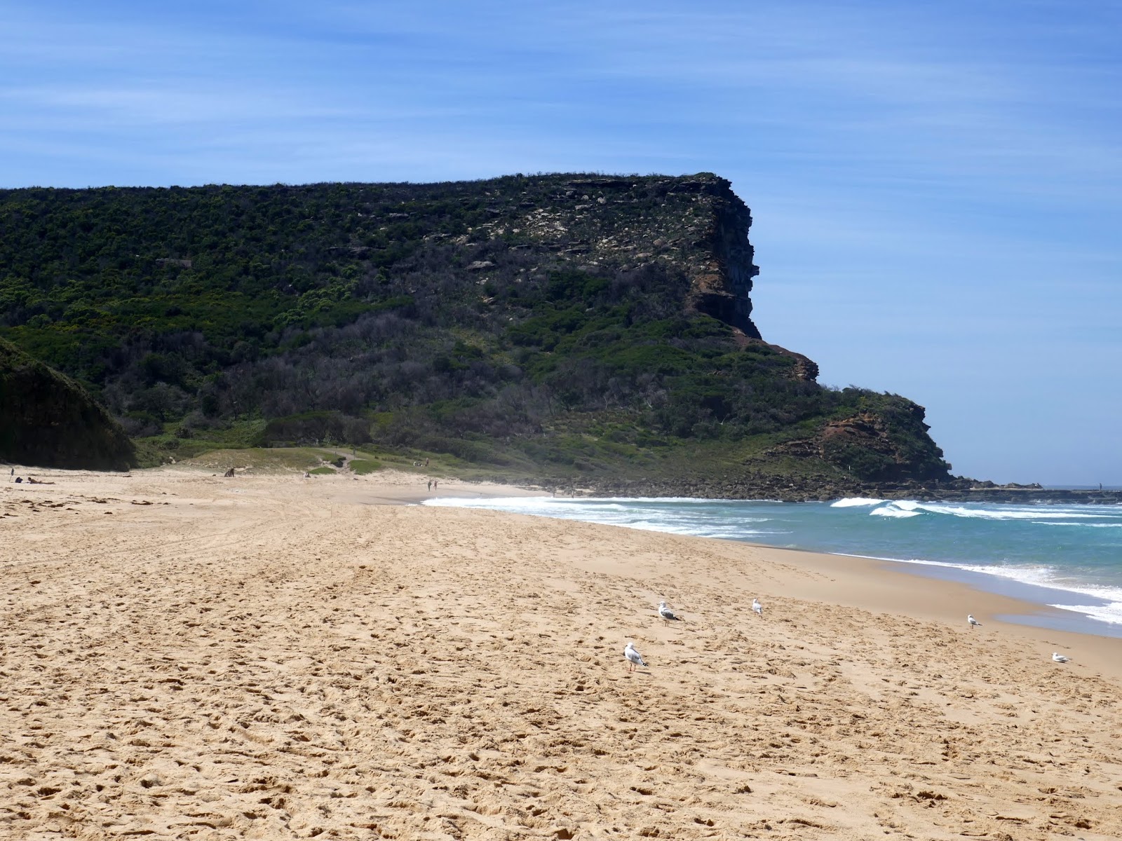
Eventually, we reached the edge of an escarpment that has a fantastic view along the southern beaches of Royal National Park. The largest in view is Garie Beach, home to some of the best surfing waves in the Sydney region. There are two theories of the origins of the name, the main is that Garie is an Aboriginal word meaning "sleepy". The name could also be a deviation of the name of a bushranger called Geaty, who was known to have camped here.
Garie Beach
Garie Beach
A steep set of steps descend the escarpment to the northern end of the beach which, given the closure of the car park, was almost deserted - the perfect place for some social distancing. At the southern end of the beach is the car park and amenities building. Having had the foresight to bring some swimming gear, we took the opportunity to cool off among the Pacific waves.
Garie Beach
Garie Beach
North Rill flows into the sea
Garie Beach
Garie Beach
The north escarpment
Garie Beach
The last part of the walk is not a particular highlight as it involves a long climb along Garie Road with little in the way of interest, other than passing the friendly staff at the ticket booths (the Royal National Park beaches have an entry fee of $12 per day). There is a lookout towards the top of the road, but the view is a little disappointing. At the top of the road is Sir Bertram Stevens Drive and a short walk back to the car.
Climbing Garie Road
Governor Game lookout
The northern escarpment
The Curra Moors and Eagle Rock circuit is an absolute classic, brilliantly combining wild coastal heath with some of the most dramatic cliff scenery in New South Wales. Standing under the sandstone overhangs to watch a waterfall tumble straight into the ocean is an unforgettable experience that easily rivals Sydney's more famous walks. Once you conquer the final steep road climb back from the surf at Garie Beach, you'll be treated to sweeping views over the southern coastline to finish a spectacular day out.


No comments :
Post a Comment