This map was created using GPS Visualizer's do-it-yourself geographic utilities.
Please wait while the map data loads...
Route: Eyam, Eyam Hall, Lydgate Graves, Stoney Middleton, Knouchley Farm, Froggatt Bridge, Froggatt, Spooner Lane, Horse Hay Coppice, Grindleford, Coppice Wood, Leadmill Bridge, Hoghall, Tor Farm, Highlow Wood, Mill Wood, Stoke Ford, Sir William Hill, Ladywash Mine, Highcliffe, Eyam
From: Eyam
Parking: Eyam
Start Point: Eyam
Region: Peak District - Dark Peak
Route length: 10.5 miles (16.9 km)
Time taken: 05:42
Average speed: 2.1 mph
Ascent: 470m
Descent: 468m
Summits: Eyam Moor (429m)
Other points of interest: Eyam, Stoney Middleton
The small village of Eyam, found in the depths of the Peak District, has become a curious attraction for tourists. It is promoted by the nickname the 'plague village' thanks to the deadly plague outbreak in the 1600s (of Black Death fame). The actions of the local villagers may well have saved hundreds of lives and had an untold effect on the spread of the disease.
The village forms the start point of this circuit around Eyam Moor, ultimately crossing the top of the moor by way of Sir William Hill on our return. I met up with my folks in the village car park late one cloudy, muggy morning (there are actually two car parks, one free and one pay and display).
 |
| The stockade opposite Eyam Hall |
The history of the plague in the village began in 1665 when a flea-infested bundle of cloth arrived from London for the local tailor. Within a week his assistant George Vicars was dead and more began dying in the household soon after.
 |
| The source of the plague outbreak in Eyam |
 |
| Eyam Parish Church |
 |
| The grave of Thomas Stanley |
 |
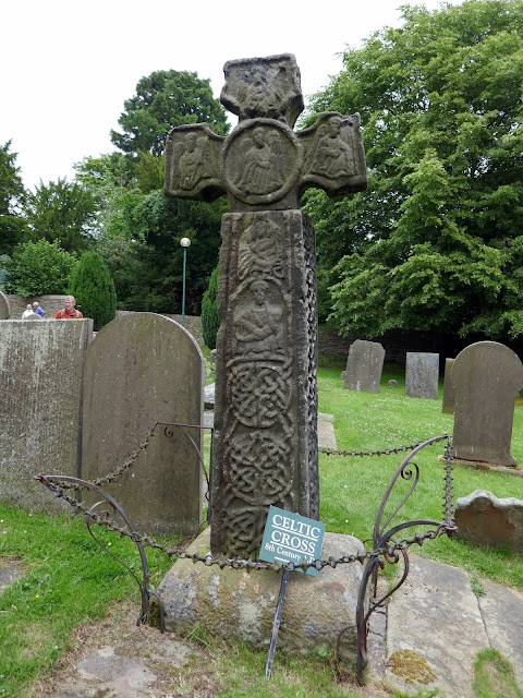
| A Celtic cross also resides in the church graveyard |
Survival among those affected appeared random, as many who remained alive had had close contact with those who died but never caught the disease. For example, Elizabeth Hancock was uninfected despite burying six children and her husband in eight days (the graves are known as the Riley graves after the farm where they lived). The unofficial village gravedigger, Marshall Howe, also survived despite handling many infected bodies
As we made our way through the village, we passed another curious remnant of Eyam's plague related past, a plague stone, sited on the boundary of the village. These stones were used to mark the perimeter of the infected area, signifying the area that should not be crossed by either inhabitant or outsider. Vinegar-soaked coins were left in holes on the stone as a means of continuing trade with other villages.
 |
| One of the plague stones around the village |
 |
| The drilled holes |
 |
| Stony Middleton |
 |
| Stoney Middleton Bath Houses |
 |
| The spring behind the bathhouses |
 |
| Eyam Moor |
 |
| The path close to Kouchley Farm |
 |
| Curbar Edge |
 |
| The River Derwent at Froggatt |
 |
| Spooner Lane |
 |
| A distant Millstone Edge |
 |
| Horse Hay Wood below Froggatt Edge |
 |
| Horse Hay Wood |
 |
| The path running through Horse Hay Coppice |
 |
| One of the many Footpath Society signs you can find in the Peak District |
 |
| The Derwent Valley Way close to Grindleford |
 |
| Green fields at Leadmill |
 |
| Stanage Edge and Hathersage |
 |
| Stoke Ford |
 |
| The path on the north side of Eyam Moor |
 |
| Dark clouds over the Dark Peak |
 |
| Abney Clough |
 |
| Offerton Moor beyond Eyam Moor |
 |
| A patchwork of colour - Mam Tor in the distance |
 |
| Eyam Moor |
 |
| Approaching the top of Eyam Moor |
 |
| A grand view over the Dark Peak |
 |
| Sir William Hill |
 |
| Add caption |
 |
| Goddards Quarry |
 |
| Back down to Eyam |

No comments :
Post a Comment