This map was created using GPS Visualizer's do-it-yourself geographic utilities.
Please wait while the map data loads...
Route: Langdale NT Campsite, Millbeck, White Gill, Blea Rigg, Stickle Tarn, Dungeon Ghyll, Mark Gate, Raven Crag, Old Dungeon Ghyll Hotel
From: Langdale NT Campsite
Parking: Langdale NT Campsite
left Start Point: Langdale NT Campsite
Region: Central Fells
Route length: 4.9 miles (7.8km)
Time taken: 2:52
Average speed: 1.7mph
Ascent: 694m
Descent: 710m
Wainwrights on this walk:
Blea Rigg (541m)
Additional summits: None
Other points of interest: Scout Crag, Whitegill Ravine, Whitegill Crag, Stickle Tarn, Raven Crag
Having climbed the head of the Langdale valley the previous day, we decided on a shorter walk to investigate some of the climbers routes up onto the lower plateau of the Langdale Pikes and Stickle Tarn. Skip once again led the way which was great as his knowledge of the area is second to none. It gave us the opportunity to investigate some of the quieter areas around the Langdale Pikes and gave me food for thought for any future trips to the area.
We set off from the campsite in the morning with a forecast for another day of fine weather. Who would have thought it? Joining the old Langdale road, we headed towards Sticklebarn, a pub owned and operated by the National Trust and the location of the previous nights excellent food.
Cutting up a path alongside the New Dungeon Ghyll Hotel, we crossed said ghyll and aimed for the path that leads underneath Swine Knott and into a small tree plantation. It's fair to say that Ella (the dog), who has quite a fondness for sticky shaped things, was in her element. A pair of climbers passed who said they were on their way to Whitegill Crag and we'd meet them later on although in slightly different circumstances.
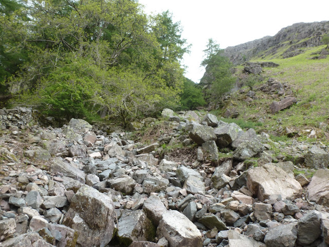
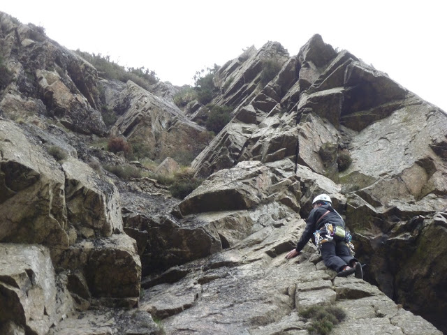
After a quick clamber along the path, we reached the foot of Whitegill ravine, a towering, boulder-filled chasm that leads directly up on to the undulating landscape to the east of Stickle Tarn. Already this looked like a more interesting route up than the popular path up Stickle Ghyll. We set off up the boulders. An intermittent path snaked up between them but most of the climb was aided by using my hands to hoist myself up the steeper sections. We paused for moment around halfway to watch some of the climbers tackle the overhanging rocks above us.
Continuing the climb, the valley splits into two distinct exit points. We decided to take the one to the right as it offered a slightly less steep climb out and generally looked a lot more straight forward.
After climbing out of the ravine, you're only a short distance to the south and west of Blea Rigg so, as Skip and Smokey waited, I wandered over to have a look at the summit. Skip had warned me of the bogs dotted around and I wish I had properly heeded his advice. A few climbs and check of the GPS to confirm which summit was the top I had added Blea Rigg to my slowly growing list of Wainwrights.
It was on my way back that I encountered one of the many bogs that had been mentioned. Seeing a damp patch, I dashed across, hoping to reach the other side with minimal contact with the water. Unfortunately, this did not happen and after only three steps I was up to my knee in the stuff. Not my finest moment. Momentum carried me out to the other side with two rather wet legs. Luckily my dash had actually prevented any water entering my boots so it was just a case of waiting for my trousers to dry off in the sun.
Reuniting myself with the gang, we wandered over to Stickle Tarn, keeping an eye out for suitable spots for wild camping. We crossed the dam that holds back Stickle Tarn, at which point Ella decided it would be easier to swim the length of it instead of walking. Impressive stuff.
It's difficult not to stand and stare at Pavey Ark, such is it's dominance of the scenery, towering high over the tarn with the notorious Jack's Rake clearly visible cut into its face. One day I'll take myself up it, but not today.
As it approached midday, we beat a hasty retreat along a quiet path underneath Harrison Stickle towards Dungeon Ghyll. Crossing the stream, we started our descent proper along the well pitched path that leads towards Mark Gate. Approaching the top of Raven Crag, we decided to make a detour down a small gully to chop of a large corner of the path.
Skip had been told of a route up (or down in this case) through another ravine adjacent to Raven Crag so we aimed for this only to find that it had been entirely fenced off, probably to prevent sheep from falling to their doom. Fortunately, a pair of climbers who had just ascended one of the many climbing routes told us of the stile and path that lead you into the ravine. We set off, crossed the stile and began down the steep ravine along a fairly obvious path.
As we approached the halfway point, we took a right turn to join a very well made path that lead underneath the face of Raven Crag and back to the New Dungeon Ghyll Hotel and the campsite. I think form now on I'll be using this route to attack the Langdale Pikes, rather than the busy route up Stickle Ghyll.
This was a fascinating day and, despite not really climbing any peaks (still managing to squeeze one in), it was a great way to spend a couple hours wandering around the quieter parts of the famous Langdale Pikes. As I've mentioned, I'll be sure to revisit these routes again in the future, they provide more interesting and less crowded routes up to Stickle Tarn and are, in essence, a more direct route up to the Langdale Pikes and the fells beyond.
Parking: Langdale NT Campsite
left Start Point: Langdale NT Campsite
Region: Central Fells
Route length: 4.9 miles (7.8km)
Time taken: 2:52
Average speed: 1.7mph
Ascent: 694m
Descent: 710m
Wainwrights on this walk:
Blea Rigg (541m)
Additional summits: None
Other points of interest: Scout Crag, Whitegill Ravine, Whitegill Crag, Stickle Tarn, Raven Crag
Having climbed the head of the Langdale valley the previous day, we decided on a shorter walk to investigate some of the climbers routes up onto the lower plateau of the Langdale Pikes and Stickle Tarn. Skip once again led the way which was great as his knowledge of the area is second to none. It gave us the opportunity to investigate some of the quieter areas around the Langdale Pikes and gave me food for thought for any future trips to the area.
We set off from the campsite in the morning with a forecast for another day of fine weather. Who would have thought it? Joining the old Langdale road, we headed towards Sticklebarn, a pub owned and operated by the National Trust and the location of the previous nights excellent food.
 |
| Stickle Ghyll just behind the New Dungeon Ghyll Hotel |
 |
| Looking up Whitegill ravine |
 |
| Langdale from the midpoint of Whitegill, once clear of the trees |
 |
| One of the climbers we met earlier on a rather tricky looking overhang |
 |
| The final part of the climb prior to the split at the top |
 |
| Great views of Langdale once you emerge from the top |
 |
| Blea Rigg guarded by the marshes |
 |
| Looking into Langdale from the summit of Blea Rigg |
Reuniting myself with the gang, we wandered over to Stickle Tarn, keeping an eye out for suitable spots for wild camping. We crossed the dam that holds back Stickle Tarn, at which point Ella decided it would be easier to swim the length of it instead of walking. Impressive stuff.
It's difficult not to stand and stare at Pavey Ark, such is it's dominance of the scenery, towering high over the tarn with the notorious Jack's Rake clearly visible cut into its face. One day I'll take myself up it, but not today.
 |
| Pavey Ark, Stickle Tarn and Ella doing her best impression of a fish |
 |
| Pike Howe from Stickle Tarn |
 |
| Looking down the gully at Mark Gate |
 |
| Raven Crag, a very popular spot for climbers |
This was a fascinating day and, despite not really climbing any peaks (still managing to squeeze one in), it was a great way to spend a couple hours wandering around the quieter parts of the famous Langdale Pikes. As I've mentioned, I'll be sure to revisit these routes again in the future, they provide more interesting and less crowded routes up to Stickle Tarn and are, in essence, a more direct route up to the Langdale Pikes and the fells beyond.

No comments :
Post a Comment