The Grand Canyon Track 11-01-2025
This map was created using GPS Visualizer's do-it-yourself geographic utilities.
Please wait while the map data loads...
Route: Neates Glen, Grand Canyon Track, Evans Lookout, Evans Lookout Road, Neates Glen
Date: 11/01/2025
From: Neates Glen
Parking: Grand Canyon Car Park
Start Point: Neates Glen
Finish Point: Evans Lookout
Region: Blue Mountains National Park
Route length: 5.7 km
Time taken: 01:10
Average speed: 5.8 km/h
Ascent: 254m
Descent: 251m
Points of Interest: Neates Glen, Greaves Creek, Evans Lookout
Beginning at Evans Lookout, the Grand Canyon Track is one of the most dramatic and popular circuits in the Blue Mountains. While not as grand as the Grand Canyon itself, the sheer sandstone cliffs of Greaves Creek make for a spectacular outing. Evans Lookout can be found near Blackheath, one of the small towns that line the Blue Mountains' high plateau, forming the popular tourist areas alongside Katoomba, Leura and the Three Sisters.
There is no right or wrong way to do the Grand Canyon Track, both routes involve descending into the canyon and climbing back out again. However, an anti-clockwise circuit means the steeper section is done in descent and the finale at Evans Lookout is saved for the end, and this is the direction we opted for. While short, the Grand Canyon is one of the best hikes in the Blue Mountains.
We began our descent from the Neates Glen parking area, following a zigzagging path that makes its way down into the rainforest, immediately passing towering ferns and dramatic overhanging rocks. It wasn't long before we encountered our first creek, Neates Glen (which gives its name to the parking area) that tumbles down a series of pretty cascades.
 |
| Descending the steps into Neates Glen |
 |
| The path winds its way down alongside Neates Glen Creek |
 |
| Neates Glen Creek |
 |
| The path follows the creek down into the canyon |
 |
| Moist ferns line much of the route |
The path descends further still, passing some outstanding viewpoints as we approached the floor of the valley. A final set of wooden steps brought us down to the banks of Greaves Creek. This is the Rotunda, an open area where the cliff has been carved out to form an overhang, over the sandy banks of the stream.
 |
| The Grand Canyon |
 |
| Following Greaves Creek |
 |
| Greaves Creek at the Rotunda |
Greaves Creek carves a winding route through the sandstone of the Blue Mountains en route to Govetts Creek before ultimately flowing to the Grose River and the mighty Nepean. It is the erosive power of the creek which creates the huge cliffs of the Grand Canyon. Now in the depths of the canyon, the path delves deeper, following the creek downstream.
We followed the trail along the cliffs to an open area surrounded by trees, ferns and running water. After squeezing through a short, dark tunnel, the path opens into another large area surrounded by huge boulders and a cascading waterfall. The path passes behind the waterfall (if it's flowing) and continues on its way.
 |
| The Grand Canyon Track |
 |
| It was a stunning day down in the canyon, made all the more atmospheric by the mist |
 |
| You'll come across this small waterfall |
 |
| The path makes its way behind the falls |
 |
| Grand Canyon |
 |
| Grand Canyon waterfall |
 |
| Greaves Creek |
 |
| Greaves Creek |
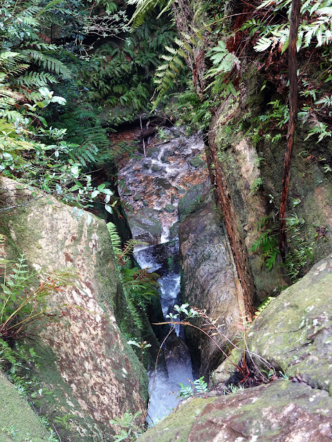
Though the track stays relatively level, the river disappears into the depths of the narrowest part of the canyon, many metres below. The canyon here is a true slot canyon, with the path perched on a ledge above the creek. Eventually, the canyon opens up again, and we began a steep descent down some wooden steps, still following the course of Greaves Creek which gets thrown over a series of waterfalls, hidden among the plants and trees.
 |
| After the waterfall, the track follows a shelf alongside the Greaves Creek slot canyon |
 |
| Greaves Creek |
 |
| Grand Canyon Track |
 |
| Greaves Creek and the Grand Canyon Track |
 |
| The Grand Canyon Track |
 |
| The Grand Canyon Track |
 |
| Looking down to Greaves Creek |
 |
| Grand Canyon Track |
 |
| Greaves Creek |
The track through the canyon was constructed in 1907, during a period when hundreds of kilometres of tracks were built to access the escarpments, lookouts, and walls of the Grose and Jamison Valleys. It has recently been restored thanks to a government grant of around $5m and is all the better for it.
Having undulated along the cliff, we again reached Greaves Creek, where it emerges from the slot canyon. Based on what we had read, we were led to believe that this was the end of our canyoning adventure, but we were wrong. The track, still following Greaves Creek, crosses the stream several times as it passes through a dramatic section of the canyon. This is arguably the most impressive section of the hike.
 |
| Greaves Creek |
 |
| The Grand Canyon |
 |
| The Grand Canyon |
 |
| Greaves Creek |
 |
| Greaves Creek |
 |
| The Grand Canyon |
 |
| The Grand Canyon |
 |
| Greaves Creek |
 |
| The track crosses the creek several times |
 |
| Greaves Creek |
 |
| Greaves Creek |
 |
| Greaves Creek |
 |
| Beginning the climb out of the canyon |
Eventually, we reached the junction at Rodriguez Pass — one of the popular tracks in the Blue Mountains. Sadly, the track, and many others in the Grose Wilderness, will be closed for the foreseeable future due to the damage caused by recent bushfires and flooding. After the path junction, we began our climb out of the canyon towards Evans Lookout.
 |
| Hiking up towards Evans Lookout |
The track climbs a long set of steps, up through a gap in the cliffs, following a series of ‘Evans Lookout’ arrows that point up the hill.
 |
| There are many, many steps to tackle |
 |
| Reaching the top of the climb |
After a heart-stirring climb, we emerged at the top of the steps below Evans Lookout. A further climb is required to reach the lookout itself, but the rewards are worth it as it has a spectacular view of the cliffs of Govetts Gorge.
 |
| A hot hazy view along Govetts Gorge |
From the lookout, a path leads through the bush back to the car park. It runs parallel to the road but keeps you away from vehicles. Before long, you'll make it back to the car park. Despite its modest length, the Grand Canyon Track is a stunning walk and I would happily repeat it.


.jpg)


.jpg)


