
This demanding circuit from Katoomba delivers some of the most spectacular—and punishing—scenery in New South Wales. Combining the precipitous drops of the historic Furber Steps, the lush Gondwana rainforest of the Federal Pass, and a gruelling double-ascent of the legendary Giant Stairway, this route is a true test of the legs. Encompassing sections of the newly established Grand Cliff Top Walk and finishing with world-class views of the Three Sisters from Echo Point is one of the most rewarding hikes in the area.
Furber Steps, Federal Pass, Grand Cliff Top Walk & Echo Point
📍 BLUE MOUNTAINS NATIONAL PARK
Distance
12.9 km
Duration
03:08 hrs
Elev Gain
+672 m
Elev Lost
-676 m
| Date | 03 May 2026 |
| Starting Point | Scenic World |
| Difficulty | Difficult |
| Pace / Gear | 4.1 km/h — Full day pack |
| Highlights | Furber Steps, Giant Stairway, Echo Point, Three Sisters |
No trip to the Blue Mountains is complete without tackling one of the steep stairways that link the clifftops to the walking tracks in the valley below. There are four major historic sets, stretching from the Golden Stairs in the west to the Grand Stairway at Wentworth Falls in the east. All date back to the Victorian era, when tourism in the Blue Mountains first began to boom.
Today, I’d be tackling two of these legendary features—the Furber Steps and the Giant Stairway—along with the connecting stretch of the Federal Pass. What makes this hike especially unique, however, is the gruelling decision to tackle the Giant Stairway twice—both times heading upward.
Hitting the Trail
After driving to Katoomba, I parked (for free) at Scenic World—a curious outdoor theme park that is home to a cable car (the Scenic Skyway) and the world’s steepest passenger railway, the 52-degree Scenic Railway (train enthusiasts may get excitable debating whether it is, in fact, a true railway). The first task of this hike is to make my way into the National Park from Scenic World.
 |
| Hitting the trail - much of the route is well-signed by the national park |
As part of the Grand Clifftop Walk, a new concrete path linking Cliff Drive to the existing trails in the national park has been constructed. It replaces a path that once passed through Scenic World, which now appears to be closed. After leaving the car park, I headed towards Cliff Drive, following it eastwards until reaching the new concrete path.
Vaniman's Lookout and the Underfalls Walk
The path ends at Vaniman’s Lookout, which offers an iconic view of the Three Sisters and Katoomba Falls—the westernmost of the tall waterfalls that cascade from the plateau into the valley below. The track then continues descending, with another viewpoint, Juliet’s Balcony, providing an equally impressive view of the falls, though it requires a short climb to reach the vantage point.
 |
| Vaniman's Lookout |
 |
| The Three Sisters |
 |
| Katoomba Falls |
A switchback in the path and some metal steps lead further downhill, past Rainforest Lookout to the Underfalls Walk track, a short out-and-back hike to the base of the first of Katoomba Falls' twin cascades, where the Kedumba River is thrown over the 300m cliffs. The short diversion is worth the modest amount of effort and time, as it takes you perilously close to the lip of the waterfall. You'll often find the enigmatic cockatoos enjoying the cool waters of the river.
 |
| Heading towards the Underfalls Track |
 |
| Rainforest Lookout |
 |
| Katoomba Falls |
 |
| The lip of the second cascade |
 |
| A close up of the falls |
The Furber Steps
The Furber Steps begin at a junction with the Underfalls Walk, starting with a steady descent to Lynes Point, which offers the best view of Katoomba Falls. From there, they plunge steeply into the valley below, hugging the cliffs and passing beneath vast sandstone overhangs. They are a sensational experience, but all too short-lived.
 |
| The top of the Furber Steps |
 |
| Furber Steps |
 |
| The original 1908 carved staircase - the most dramatic part of the Furber Steps |
 |
| Furber Steps |
 |
| The lower section of the steps, approaching Federal Pass |
The Furber Steps were constructed in 1908 to replace the bush pole steps of the original Federal Pass. The name 'bush-poles' sounds precarious on its own, let alone down the side of a sandstone cliff. Thomas Furber, a Lands Department surveyor with an interest in conservation, was mainly responsible for obtaining a government grant of £140 for the work. The photo below was taken at the completion of the project. While the vegetation has grown back, the amazing feat of construction can be clearly seen.
 |
| The Furber Steps in 1908 |
Nowadays, the Furber Steps join the Federal Pass partway between Scenic Station and Katoomba Falls View. If the thought of climbing out of the valley fills you with dread, I’d highly recommend descending via the Furber Steps and taking the Scenic Railway back up instead (fees apply).
The Federal Pass
The Federal Pass is one of the longer tracks in the Blue Mountains, linking the town of Leura in the east with Ruined Castle in the west via the base of the cliffs. It was originally built by the Katoomba community from Leura Forest to Katoomba Falls before later being extended along an old horse-drawn coal tramway line. From the bottom of the Furber Steps, I would be hiking the original section, between Katoomba Falls and Leura Forest.
 |
| Turpentine tree on Federal Pass |
 |
| Federal Pass |
 |
| Picnic area at Katoomba Falls View |
Federal Pass is a very pleasant route—generally flat and sheltered from the heat of the sun. It crosses the Kedumba River before continuing through the bush to the tip of the Three Sisters ridge, where it meets Dardanelles Pass—a track built to link the Giant Stairway with the Federal Pass. From here, the Federal Pass dips down into the rainforest, while Dardanelles Pass maintains a more level course, the two rejoining nearly 2 km later.
 |
| Federal Pass |
 |
| Halfway marker stone |
 |
| The Dardanelles Pass / Federal Pass junction |
 |
| There are occasional views of Mount Solitary |
 |
| The bottom of the Giant Stairway |
The Giant Stairway – Part 1
The 800 steps of the Giant Stairway are narrow and steep, with a sturdy guardrail protecting walkers from the imposing drop below. The stairway was conceived in 1914, and construction began in 1916, but work was halted after only a quarter had been completed due to cost. It was not until 1932 that construction resumed, following lobbying by a local photographer. The Giant Stairway was officially opened by the Premier, the Hon. B. S. B. Stevens, at the same time as the platform at Echo Point.
 |
| Steel steps on the Giant Stairway |
 |
| Giant Stairway |
 |
| Looking down |
 |
| Looking up |
Close to the top of the stairs is Honeymoon Bridge, a short bridge across a chasm that links the tallest of the Three Sisters to the main ridge (access onto the bridge is currently restricted). Further climbing on the towers is prohibited due to their cultural significance with the Aboriginal traditional owners, the Gundungurra Nation.
The Giant Stairway eventually emerges at Lady Game / Oreades Lookout, directly behind Meehni, the tallest of the Three Sisters.
 |
| Jamison Valley |
 |
| Jamison Valley |
 |
| Meehni and Mount Solitary |
The Grand Cliff Top Track / Prince Henry Cliff Walk
From here, I continued east along the clifftop, following one of the Blue Mountains’ most scenic tracks; the Prince Henry Cliff Walk. From the lookout, it’s a short link-up to the track, which also forms part of the Grand Cliff Top Walk—the area’s newest hiking trail. It's easy hiking for a few kilometres, passing a number of lookouts that peer down into the valley below. The best of these is Bridal Veil Falls Lookout, which has a superb view of the waterfall after which is it named.
 |
| The Prince Henry Cliff Walk above Oreades Lookout |
 |
| Prince Henry Cliff Walk |
 |
| Honeymoon Lookout |
 |
| Bridal Veil View on the opposite side of the valley |
 |
| Rock formations at Burrabarroo Lookout |
 |
| View from Fossil Rock Lookout |
 |
| Bridal Veil Falls |
Bridal Veil Falls and the Amphitheatre Track
I had previously decided that, instead of diving straight down Federal Pass from Cliff Drive, I'd add the additional short loop along the Leura Cascades Round Walk and Amphitheatre Tracks, where the track makes its way steeply downhill to the base of Bridal Veil Falls. The multi-tiered fall is spectacular, especially after some rain. The view from the foot of the falls gives a unique aspect, with the waterfall appearing as a tall pyramid of rock.
 |
| Heading down the Amphitheatre Track |
 |
| Amphitheatre Track |
 |
| Bridal Veil Falls |
 |
| Weeping Rock |
 |
| Ampitheatre Track |
From the falls, the path narrows into the Amphitheatre Track. The beautiful Amphitheatre Track follows the cliff wall into the Amphitheatre, where the cliff walls tower above in a graceful curve before eventually emerging at Fern Bower and the Federal Pass.
 |
| The Amphitheatre |
Fern Bower, Federal Pass and Leura Forest
Federal Pass descends through a long series of wooden steps and steel stairways, following Linda Creek past several small cascades. Originally constructed in 1894, sections of the track still retain elements of the original works, including earth benching and stone steps, though much of it has since been upgraded.
The first named waterfall encountered is Lila Falls, located on the right-hand side of the track just before the junction with the Amphitheatre Track. Further along is Linda Falls, widely regarded as the most picturesque along Federal Pass. The track continues downhill to Marguerite Cascades, another particularly photogenic section of the creek. Once past the cascade, the track emerges in Leura Forest.
 |
| Linda Falls |
 |
| Federal Pass |
 |
| Federal Pass |
 |
| Federal Pass |
 |
| Federal Pass |
 |
| Marguerite Cascades |
 |
| The bottom of the |
 |
| Leura Forest |
 |
| Leura Forest |
 |
| Leura Forest |
Giant Stairway - Part 2
At the southern end of the forest (if you can call it an end) is the Dardanelles Pass / Federal Pass junction. Once again, I chose Dardanelles Pass, which cuts an undulating route to the foot of the Giant Stairway. Once again, I climbed the 900 or so steps to Oreades Lookout, pausing occasionally to take in the views.
 |
| Giant Stairway |
 |
| Giant Stairway |
 |
| Another 1/2 way marker - this time on the Giant Stairway |
 |
| The most dramatic section of the Giant Stairway |
 |
| Giant Stairway |
 |
| Giant Stairway |
 |
| Approaching the top |
 |
| Honeymoon Bridge |
 |
| Jamison Valley |
 |
| Meehni and Mount Solitary |
Echo Point and the Three Sisters
From Oreades Lookout its an easy stroll along a wide, concrete path to Echo Point. Echo Point is a busy destination, with most—if not all—tour groups from Sydney converging here and bringing hundreds of visitors each day. In recent years, the lookout has been expanded and upgraded to better accommodate these crowds. The view of the Three Sisters from Echo Point is the defining image of the Blue Mountains—one that appears instantly with even the quickest online search.
 |
| Echo Point |
 |
| The iconic view of the Three Sisters from Echo Point |
 |
| Ruined Castle and Castle Head |
 |
| The Three Sisters |
A commonly told legend of the Three Sisters tells of three sisters—Meehni, Wimlah and Gunnedoo—who lived in the Jamison Valley as members of the Katoomba tribe. They fell in love with three brothers from the neighbouring Nepean tribe, but tribal law forbade their marriage. Unwilling to accept this, the brothers attempted to take the sisters by force, sparking a major tribal conflict. To protect them, an elder turned the sisters to stone but was killed in the fighting before he could reverse the spell, leaving them as they remain today.
The Grand Cliff Top Track / Prince Henry Cliff Walk
Heading west away from Echo Point, the Prince Henry Cliff Walk descends several flights of steps until it reaches the impressive Lady Darley's Lookout. A set of narrow metal steps descends an outcrop of rock with an imposing view of the valley. A handful of other lookouts are passed before reaching the Scenic Skyway East Station, where the Scenic World cable car terminates.
 |
| Prince Henry Cliff Walk |
 |
| Lady Darley Lookout |
 |
| Malaita Point |
 |
| Scenic Skway |
 |
| Scenic World |
 |
| Jamison Valley |
The Cliff Walk does a loop under the Katoomba Cascades, a picturesque set of waterfalls on the Kedumba River which sits just below a road and a park. The river can be crossed by a set of stepping stones or a small footbridge (presumably for times when the flow is high). A last recommended port of call is Reids Plateau, a short circuit of a sandstone outcrop with several viewpoints of the valley, including Orphan Rock (though it was closed today while the council did some trackwork). From here, it's a short hike back to the car park at Scenic World.
 |
| Katoomba Falls Kiosk |
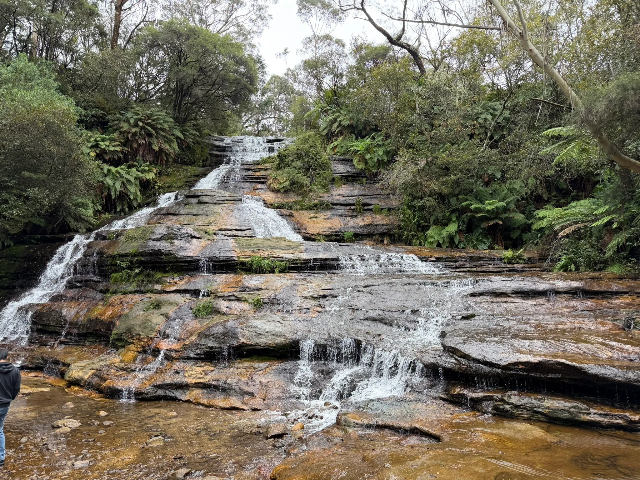 |
| Katoomba Cascades |
Arriving back at the car park marked the end of an exhausting but incredibly rewarding day on the trails. There is no denying that hauling myself up the Giant Stairway twice took a heavy toll on the legs, but the sheer variety of this circuit makes every step worthwhile. Whether you choose to punish your calves as I did, or take the slightly more sensible option of riding the Scenic Railway out of the valley, this loop captures the absolute best of the Blue Mountains' rugged majesty.


No comments :
Post a Comment