Greenwich Point, Berry Island & Balls Head 28-11-2021
This map was created using GPS Visualizer's do-it-yourself geographic utilities.
Please wait while the map data loads...
Route: St Leonards, Gore Hill Cemetery, Princes Highway, Lane Cove Bushland Park, River Road, Lillypilly Falls, Gore Creek Reserve, Greenwich Point, Manns Point, Greenwich Road, Holloway Park, Gove Cove, Gore Cove Track, Berry Island, Gadyan Track, Bandangi Reserve, HMAS Waterhen, Balls Head Reserve, BP Site Reserve, Waverton Park, Blues Point, McMahons Wharf, Bayview Street, Lenender Bay, Luna Park, Milsons Point, Stanton Lookout, Cahill Walk, Sydney Habour Bridge, Cahill Expressway, Circular Quay
Date: 28/11/2021
From: St Leonards
Parking: N/A
Start Point: Lane Cove Bushland Park
Finish Point: Circular Quay
Region: Sydney
Route length: 20km
Time taken: 05:04
Average speed: 3.9km/h
Ascent: 552m
Descent: 634m
Points of Interest: Lillypilly Falls, Berry Island, Balls Head Reserve, Sydney Harbour Bridge
While lacking motivation for a long drive, I cast my eyes over the Sydney Harbour for some hiking inspiration, eventually resting on the northern shoreline between Northwood and Blues Point, west of the harbour bridge. This quiet area is where the Lane Cove River meets the Parramatta River and is home to a few interesting headlands and bays that looked worthy of exploration. While I was not expecting great things, this hike ended up being far more interesting than I had anticipated, especially considering it is within the city of Sydney.
Being in the city means that ample public transport is available for a one-way, point-to-point hike which would include crossing the Sydney Harbour Bridge. I decided to start the hike from St. Leonards train station, aiming for the Lane Cove Bushland Park.
 |
| A game of cricket at the Gore Hill Oval |
I first had to negotiate my way around the Royal North Shore Hospital and Gore Hill Cemetery. The cemetery at Gore Hill Gore is one of the oldest and largest remaining cemeteries in metropolitan Sydney, having been established in 1868. Many of the pioneers of Sydney's North Shore are buried in the cemetery. The cemetery now resides alongside the Pacific Highway which I followed to a small path that leads into Ronald Park and the top of the Bushland Park.
 |
| Gore Hill Cemetery |
 |
| Ronald Park |
 |
| Colourful Rainbow Lorikeets in Ronald Park |
The park exists thanks to the efforts of the local conservation society, whose active local residents saved the area from destruction in the 1970s. The campaign to save the area was the genesis of the Lane Cove Bushland & Conservation Society, which celebrated 50 years of continuous work in 2021. The park is centred around Gore Creek and is quite beautiful, especially considering it is surrounded by the urban sprawl of North Sydney.
 |
| Entering the Lane Cove Bushland Park |
 |
| Gore Creek |
 |
| Gore Creek |
 |
| Gore Creek |
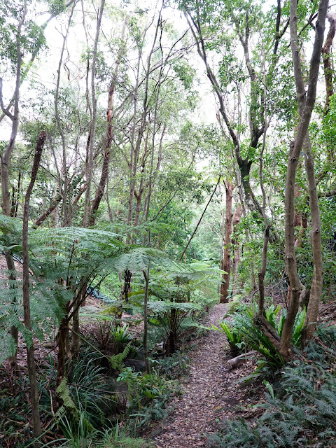
I followed the creek to River Road, where it continues towards the Lane Cove River, passing the charming Lillypilly waterfall. The falls and water pool below were once a popular picnic and bathing spot, however, urban development upstream has severely affected the amount of water coming over the falls and the pool is heavily silted. That said, they are still quite impressive after heavy rain.
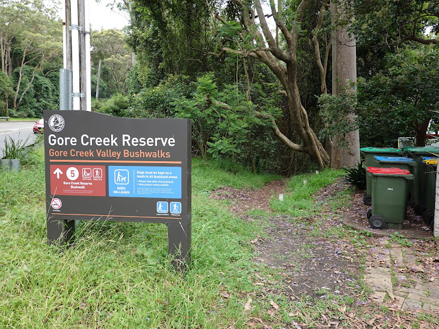 |
| The unassuming entrance to Gore Creek Reserve |
 |
| Lillypilly Falls |
 |
| Lillypilly Falls |
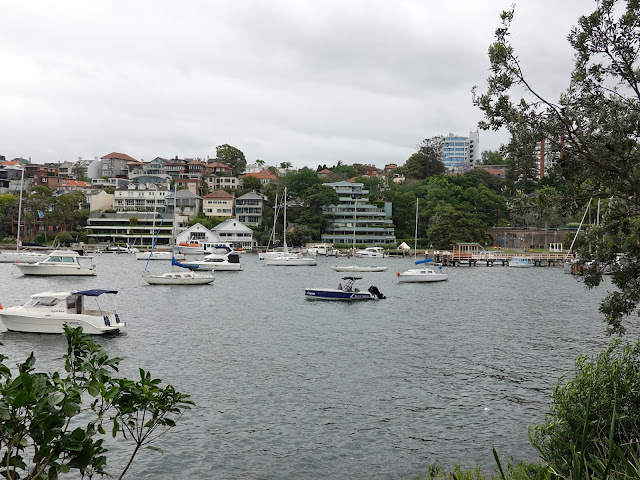
Gore Creek flows into Lane Cove River at Gore Creek Reserve after which a slightly convoluted route through the streets of Greenwich will take you to Greenwich Point Reserve. The fringe of greenery envelopes the suburb of Greenwich, a peninsula that juts out into the Parramatta River. The grassed waterfront at Manns Point has a panoramic view of the harbour and the city.
 |
Gore Cove | | Greenwich Point |
|
 |
| Woolwich Dock |
 |
| Houses in Birchgrove |
 |
| Balmain with the Sydney CBD beyond |
 |
| Parramatta River |
 |
| Crown Tower |
 |
| Parramatta River from Manns Point |
 |
| The Berry Island causeway |
 |
| Berry Island |
After some more weaving through the streets of Greenwich, I made my way to Vista Street and down to Gore Cove Reserve. The path skirts the edge of Gore Cove, where you will find an impressive stand of mangrove trees until it reaches a steep hill on Shirley Road. The hill leads down towards Berry Island.
 |
| Holloway Park / Gore Cove |
 |
| Gore Cove |
 |
| Gore Cove |
 |
| Approaching Berry Island |
As its name suggests, Berry Island was once an island before it was connected by the mainland by a concrete causeway in the 19th Century. Now a peninsula, Berry Island is one of North Sydney's most significant areas of harbourside bushland, home to some relatively untouched remnant Hawkesbury Sandstone vegetation, including the famous Sydney Red Gums. The Gadyan Track is a 20-minute bush walk that loops the island and interprets Berry Island's Aboriginal history. The Aboriginal history of the island is indicated by the numerous shell middens, axe-grinding grooves and a large engraving.
 |
| The Gadyan Track |
 |
| Aboriginal carvings site on Berry Island |
 |
| Crown Tower and Darling Harbour |
 |
| Bandangi Reserve |
 |
| Bandangi Reserve |
After a swift circuit of the island, it was back up Shirley Road to Bandangi Reserve and a steep set of steps adjacent to HMAS Waterhen, Australia's establishment for mine warfare. The naval base guards the entrance to Balls Head Reserve.
The reserve is arguably the highlight of this hike thanks to its combination of industrial heritage and bushland tracks, topped off by a sweeping view of Sydney Harbour, made all the better thanks to the sun appearing for a few minutes. It is named after Henry Lidgbird Ball, a Royal Navy commander of one of the First Fleet ships, though has been known as Yerroulbine by the Cammeraygal people who lived in the area for thousands of years. In addition to the bush tracks, Balls Head is home to the Coal Loader, a former coal transfer depot before being decommissioned in the 1990s. Since then, it has been transformed into the Coal Loader Centre of Sustainability.
 |
| Rock carvings at Balls Head |
 |
| The Coal Loader |
 |
| The Coal Loader tunnel |
 |
| Balls Head Reserve |
 |
| The view of Sydney from Balls Head |
 |
| The Sydney Opera House hidden behind the harbour bridge pylon |
 |
| Sydney Habour Bridge and the incongruous Blues Point Tower |
 |
| Goat Island |
 |
| Wharves at Walsh Bay |
Adjacent to Balls Head is Carradah Park. It overlooks Berrys Bay and was once an oil storage facility - hence its alternative name, BP Site Reserve. Some remnants of the industrial use were retained and incorporated into the new design for the park. For example, the foundations for the oil storage tanks are now circular lawns.
 |
| BP Site Reserve |
 |
| North Sydney |
 |
| BP Site Reserve |
A set of steps leads into Waverton Park and some more suburban walking until I reached Blue Point and the infamous Blues Point Tower. The 82m tall apartment block was supposed to be part of a wider redevelopment of Blues Point in the 1960s. However, support waned and Blues Point Tower was the only element built. Therefore, it stands isolated in one of the prime areas of Sydney Harbour. The building is regarded by some critics as one of the ugliest buildings in Sydney, inconsistent with its surrounding buildings and cityscape. It is likely to be Sydney's most hated building.
Fortunately, you can't see the tower while standing at Blues Point which, along with McMahons Point, has a world-class view of Sydney Harbour Bridge and the Sydney Opera House beyond.
 |
| Crown Tower and Barangaroo Reserve |
 |
| Sydney from Blues Point |
 |
| Icons of Sydney |
 |
| Sydney Harbour Bridge |
 |
| Lavender Bay |
 |
| Lavender Bay |
From the top end of Lavender Bay is a boardwalk that follows the east side of the bay to charming Luna Park. This vintage theme park was constructed in the 1930s and has a collection of now-vintage rides. It is one of only two amusement parks in the world that are protected by government legislation, the other being Tivoli Gardens in Denmark.
Luna Park's famous smiling face (at the southern entrance), as well as its flanking towers, have presided over the main entrance for almost all of the park's existence. There have been eight distinct faces with the current Face, completed in 1994 and carved from polyurethane, based on the 1950 "Old King Cole" version.
 |
| Sydney Harbour Bridge |
 |
| Sydney Opera House |
 |
| Milsons Point |
 |
| The entrance to Luna Park |
 |
| The view from Milsons Point |
From Luna Park, I passed beneath the Sydney Harbour Bridge to Milsons Point and followed Olympic Drive as it swings uphill to the Stanton Lookout. Broughton Street continues north into Kirribilli where there is a set of steps that take you up to the Cahill Expressway and the Cahill Walk, the path that crosses the Sydney Harbour Bridge.
 |
| Sydney Opera House |
 |
| Stanton Lookout |
 |
| Steps up the Cahill Walk |
 |
| The Cahill Expressway |
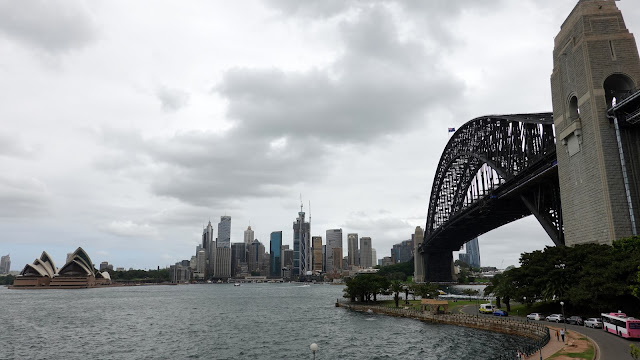
The bridge was designed and built by British firm Dorman Long of Middlesbrough and opened in 1932 (they later went on to build the Tyne Bridge in Newcastle - hence the similarities). It is currently the tenth-longest spanning-arch bridge in the world and the tallest steel arch bridge, measuring 134m from top to water level. It is a magnificent beast.
In addition to the road, the Harbour Bridge carries a railway and a protected pedestrian footpath which gives a superb view of Sydney Harbour and the iconic Sydney Opera House as well as an intimate view of the steel structure of the bridge itself.
 |
| Sydney Harbour Bridge |
 |
| Sydney Opera House and Circular Quay |
 |
| The many girders that support the harbour bridge |
 |
| Fort Denison |
 |
| Sydney Opera House |
 |
| The Rocks area of Sydney |
 |
| Cahill Walk |
 |
| Glenmore Hotel |
After getting across the bridge, I continued along the Cahill Expressway as it crosses over Circular Quay and the Rocks. While generally unliked, it does have one of Sydney's more famous views, looking along Harrington Street towards the harbour bridge.
 |
| A popular view of the Rocks area with Sydney Harbour Bridge |
 |
| Sydney Harbour Bridge |
 |
| First Fleet Park |
 |
| The Museum of Contemporary Art lines one side of Circular Quay |
 |
| Circular Quay |
 |
| Sydney Harbour Bridge |
 |
| Looking back to Milsons Point beneath the harbour bridge |
At the far end of the Expressway is a loft that will take you down to Circular Quay where I brought my urban hike to a close. You could continue into the Botanic Gardens, which are beautiful, however, I was content with my north-shore exploration.

No comments :
Post a Comment