Snowdon via the Watkin Path 19-05-2018
This map was created using GPS Visualizer's do-it-yourself geographic utilities.
Please wait while the map data loads...
Route: Bethania, Nantgwynant, Plascwmllan, Gladstone Rock, Bwlch Ciliau, Bwlch y Caethau, Snowdon, Bwlch Main, Clogwyn Du, Allt Maenderyn, Bwlch Cwm Llan, Cwm Llan, Bethania
Date: 19/05/2018
From: Bethania
Parking: Bethania
Start Point: Bethania
Region: Snowdonia - Snowdon
Route length: 8.3 miles (13.35 km)
Time taken: 04:26
Average speed: 1.9 mph
Ascent: 1,096m
Descent: 1,098m
Summits: Yr Wydffa (1,085m)
Other points of interest: Cwm Llan, Plascwmllan, Gladstone Rock
The Watkin Path is said to be the toughest route to the summit of Snowdon with a challenging final ascent (aside from Crib Goch, of course). That said, it's also regarded as having some of the best views of any of the ‘classic’ routes to the summit. Starting just a few metres above sea level, the route offers the biggest vertical ascent gain, as well as sections of steep and loose scree making the final approach demanding.
The Watkin Path was first opened in 1892 by Prime Minister William Gladstone in front of 2,000 people. This was the first official footpath in Great Britain, hence the importance of the ‘Gladstone Rock’, which resides along the route. Sir Edward Watkin created this path from the existing quarry path to the summit of Snowdon to allow walkers to climb to the peak, though it was never truly finished, as you'll see later.
Sir Edward William Watkin was a British Member of Parliament and railway entrepreneur - an ambitious visionary and presided over large-scale railway engineering projects to fulfil his business aspirations before retiring to a chalet in the depths of Cwm Llan.
The path begins in Bethania, close to the entrance to the National Trust farm at Hafod y Llan. A slate sign marks the 'Watkin Path’ and stone steps lead up into the woods.
 |
| The beginning of the Watkin Path |
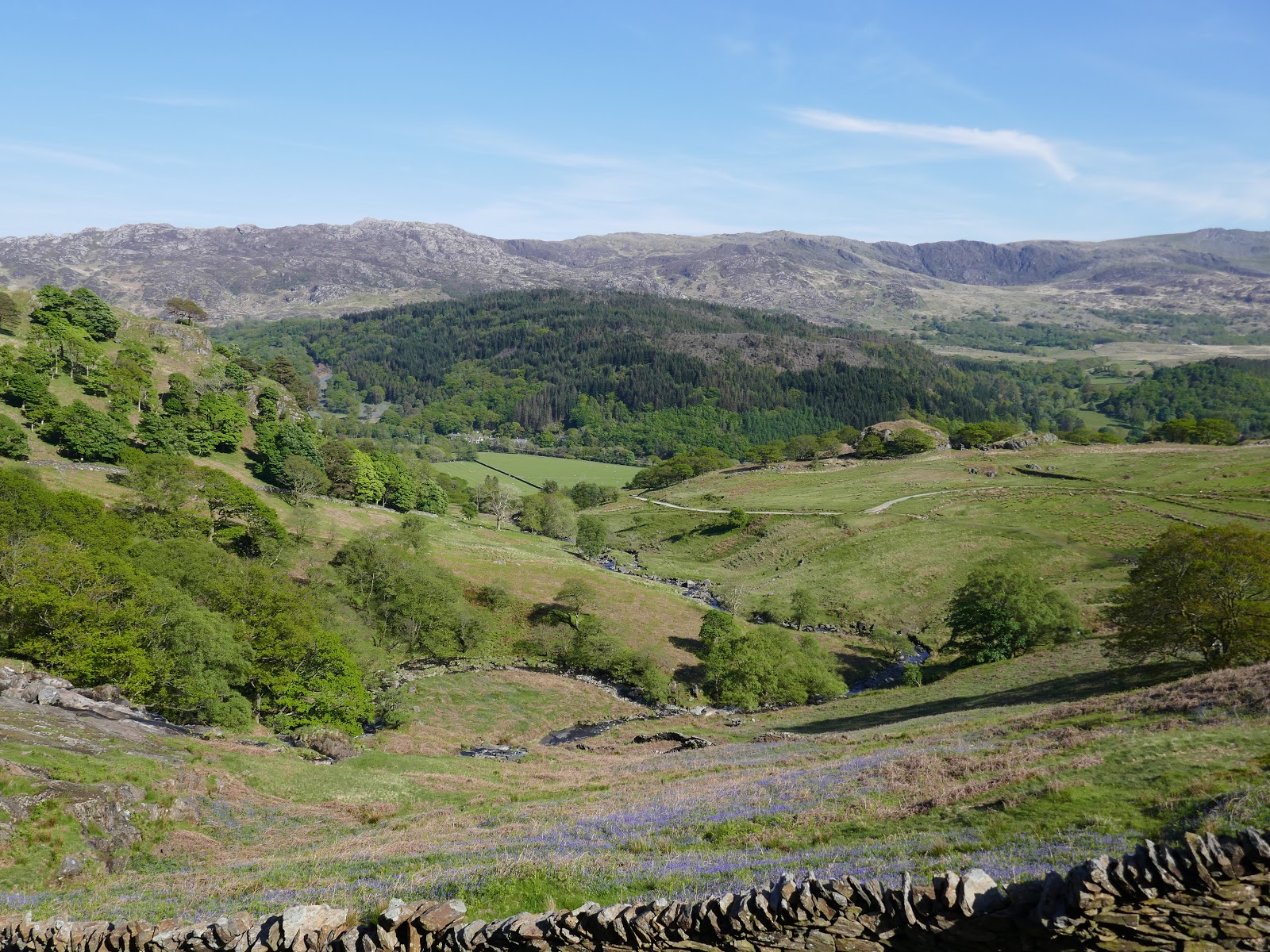
Walking is easy for a couple of miles as the track climbs gently through Cwm Llan, taking a big arc around the waterfalls of the Afon Cwm Llan. The path climbs and returns to the river where you will find sheep pens made of traditional slate fencing and then the ruins of Plas Cwm Llan – which used to be the home of the South Snowdon Slate Quarry manager. During the Second World War, soldiers used this building as a target when training for “D Day”.
 |
| Hafod-y-llan |
 |
| Gallt y Wenallt |
 |
| The waterfalls of Afon Cwm Llan below Craig Ddu |
 |
| Craig Ddu and Y Lliwedd |
 |
| Looking across Nanygwynant towards the Moelwyns |
 |
| The Watkin Path at Plascwmllan |
 |
| Plascwmllan |
 |
| Quarry building at Plascwmllan |
 |
| Afon Cwm Llan |
 |
| The old quarry managers barracks |
Keeping right after the path forks, the Watkin Path passes the Gladstone Rock from where Prime Minister William Gladstone addressed 2,000 people during the opening of the path.
 |
| Gladstone Rock |
 |
| The inscription on Gladstone Rock |
 |
| Gladstone Rock |
After the relatively gentle start, the Watkin Path begins the serious business of climbing towards Snowdon's summit. The first steep section climbs through the old quarry spoil at 350m, all the way up to Bwlch Ciliau at over 700m. Though steep, the path has numerous steps to climb and has magnificent views of Cwm Tregalan, the brooding cliffs of Clogwyn Du, the shapely Yr Aran and, of course, Snowdon itself.
 |
| Cwm Llan flanked by Yr Aran and Craig Ddu |
 |
| Craig Ddu |
 |
| Yr Aran |
 |
| Cwm Tergalan panorama |
 |
| The Watkin Path above Cwm Tregalan |
 |
| Yr Aran |
 |
| Snowdon |
 |
| Snowdon |
 |
| Snowdon |
Bwlch Ciliau has its own staggering views, this time into Llyn Llydaw and across to Crib Goch, framed by Y Lliwedd to the east and Snowdon to the west. The Watkin Path only climbs a few more metres up to Bwlch y Saethau where I think Sir Edward Watkin ran out of ideas.
 |
| Llyn Llydaw from Bwlch Ciliau |
 |
| Crib Goch |
 |
| Panorama from Bwlch Ciliau |
 |
| Y Lliwedd |
 |
| Y Lliwedd |
 |
| The Watkin Path as it approaches its steep final climb |
From the Bwlch, the Watkin Path makes a severely steep climb up loose scree to reach the Rhyd-Ddu path. It's know to be a bit of an accident blackspot, especially if it's damp which makes it even looser than it already is. The climb doesn't follow one particular line either, so my advice is to pick your route carefully and don't rush. Eventually, the hard work is done.
 |
| Cwm Tregalan |
 |
| Looking down the Watkin Path |
 |
| The Watkin Path |
 |
| New steps at the top of the Watkin Path |
As you well know, the summit of Snowdon is home to a railway station, bringing hundreds of tourists up from Llanberis without the arduous three-hour climb. It can be a strange sensation to be rubbing shoulders with grandparents and toddlers alike having hiked up from the bottom. That said, I love it - there's nothing quite like it in the country. The summit was absolutely mobbed.
 |
| The final few metres towards Snowdon |
 |
| Panorama of Cwm Tregalan |
 |
| The Nantlle Ridge |
 |
| Hafod Eryri |
 |
| Crib Goch |
 |
| Garnedd Ugain |
 |
| The Pyg Track at Bwlch Glas |
 |
| The Snowdon Mountain Railway |
 |
| Hafod Eryri |
The views, however, are stunning.
 |
| Snowdon's incredible view |
 |
| Mynydd Mawr |
Bwlch Main is the narrow ridge that joins the south ridge and the Rhyd-Ddu path to the summit of Snowdon. It has some Striding Edge proportions to it though, in reality, never actually feels that narrow. It's a magnificent place.
 |
| The dark cliffs of Llechog |
 |
| Cwm Clogwyn |
 |
| Bwlch Main |
 |
| Bwlch Main |
 |
| The South ridge leading to Yr Aran |
After crossing Bwlch Main, our route took us down Snowdon's south ridge which runs across the top of the cliffs of Clogwyn Du to Allt Maenderyn. Aside from one or two rocky steps, it's a very easy route of descent at a nice gradient with a well-established path. It's also very quiet - we hardly saw a soul after leaving Snowdon's summit.
 |
| Yr Aran |
 |
| Quarries along the Rhyd-Ddu path |
 |
| Y Lliwedd |
 |
| The damp path along Cwm Llan |
 |
| The Cwm Llan quarries |
 |
| Craig Ddu |
As things begin to dry out a bit, the path reaches an old quarry track that runs to a disused incline at Clogwyn Brith though there's no need to go that far and the incline is probably too steep anyway. Instead, a stepped path follows a small stream down to the Watkin Path at Plascwmllan. From here, its a case of retracing the route back to the car park.
 |
| Descending back to the Watkin Path |
 |
| Afon Cwm Llan |
 |
| Returning to Bethania |
I thoroughly enjoyed the Watkin Path, despite the steep scree section at the end which shouldn't detract from an excellent route. Combining it with the south ridge makes for a great day out with sensational views throughout the day, especially from Bwlch Ciliau and Bwlch Main. Snowdon is usually guaranteed a good day out and this route is one of the best.


No comments :
Post a Comment