Saturday 21 April 2018

The Snowdon Horseshoe

The Snowdon Horseshoe 21-04-2018

This map was created using GPS Visualizer's do-it-yourself geographic utilities.

Please wait while the map data loads...


Route: Pen-y-Gwyrd, Bwlch y Gwyddel, Pen-y-pass, Pyg Track, Bwlch y Moch, Crib Goch, Bwlch Coch, Garnedd Ugain, Crib-y-Ddysgl, Bwlch Glas, Yr Wyddfa, Watkin Path, Bwlch y Saethau, Bwlch Ciliau, Y Lliwedd West Peak, Y Lliwedd East Peak, Lliwedd Bach, Gallt y Wenallt Llyn Llydaw, Cwm Dyli, Miners' Track, Pen-y-pass, Pen-y-Gwyrd

Date: 21/04/2018
From: Pen-y-Gwyrd Hotel


Parking: Laybys on A498
Start Point: Pen-y-pass
Region: Snowdonia

Route length: 11.7 miles (18.8 km)
Time taken: 06:11
Average speed: 1.9 mph
Ascent: 1,402m
Descent: 1,397m

Summits: Crib Goch (923m), Garnedd Ugain (1065m), Yr Wyddfa (1085m), Y Lliwedd (898m), Y Lliwedd East Peak (893m), Lliwedd Bach (818m), Gallt y Wenallt (619m)

Other points of interest: Glaslyn, Summit Station, Hefod Eryri

The Snowdon Horseshoe needs little introduction. It is widely regarded as one of the best mountain days in the whole country, and probably the best outside of Scotland.

This would be my second attempt at the Snowdon Horseshoe after completing it a few years ago under the watchful eye of a Mountain Leader. This time, confident in my skills and the route, I would be tackling it alone. That said, being a Saturday with superb weather, it was highly unlikely that I would have the ridge to myself.
The Snowdon Horseshoe seen from the layby on the A498
Snowdon in the early morning light
I arrived at Pen y Pass at 7am, hoping to find a space but, alas, it was already full, even at that time in the morning. Instead, I defaulted to plan B which was to park over the county boundary in Conwy and walk back up to the pass - an addition of around a mile each way.
The path from Pen-y-Gwyrd at Nant Cynnyd
After a car boot breakfast and cup of coffee, I set off to the Pen-y-Gwyrd Hotel and onto the recently built path that avoids a perilous walk along the road. Once at Pen y Pass, it was obvious it was going to be a busy day. Scores of people were either hanging around at the toilets or setting off for the mountain and it was only 8am. I don't blame them - Snowdon is a must when the weather is clear.
Gallt yr Wenallt
Craig Llyn Teryn
Following a large group, I joined the Pyg Track as it starts its climb around the crags of Careg Gwalch and up to Bwlch y Moch - the Pass of the Pig. I passed the large group as they stopped to wait for their comrades leaving me free to make the diversion towards Crib Goch, following in the wake of a well-prepared looking couple.
Looking down to Nanygwynant
Crib Goch from the Pyg Track
The Llanberis Pass
Crib Goch
Leaving the Pyg Track ay Bwlch y Moch
I'm told that some people mistake Crib Goch for Snowdon as it's the largest and pointiest thing that can be seen as you reach Bwlch y Moch though there are now several signs to attempt to discourage people from making this mistake. Crib Goch is not a place to find yourself unexpectedly.
A warning posted on one of the stiles
The initial climb up Crib Goch's lower slopes is scruffy and steep, mostly climbing rough scree or an indistinct path. Around halfway is a rocky wall that requires some entertaining scrambling - all at Grade 1 - after which the character of the ridge changes.
Crib Goch
Craig Fach and Llyn Llydaw
Panorama from Bwlch y Moch
Crib Goch
The Glyders
Starting the climb up Crib Goch
Looking down to Llyn Llydaw
After the rocky step, Crib Goch becomes more blocky in its appearance you'll no doubt have seen in numerous pictures. It's still very much hands-on as you climb up the ridge towards an obvious summit, leaving Llyn Llydaw and the Afon Nant Peris far below. I took my time as I was quickly gaining ground on another large group but, despite my best attempts, we arrived at Crib Goch's eastern top at the same time.
Crib Goch's east ridge
Scrambling up towards the eastern top
Glyder Fawr
The east ridge
The east ridge
Snowdon and Crib Goch
The ridge is an awe-inspiring sight and not one for the faint-hearted. 500ft drops on either side make it an intimidating place but the crest of the ridge makes an ideal handhold and adds a measure of reassurance. It is possible to walk right along the top and there are many places where this is the easiest option if you can stomach the exposure.
Crib Goch
Crib Goch
Setting off along the ridge
Crib Goch
Cwm Uchaf and Garnedd Ugain
Cwm Uchaf and Llyn Glas
Crib Goch
Y Lliwedd, Snowdon and Garnedd Ugain from Crib Goch's summit
I made it to the summit which stands around halfway along the ridge and paused to take in the surroundings having managed to pass much of the group as they edged along. Up ahead are the tall, spiky pinnacles that need to be negotiated before you can reach the relative safety of Bwlch Coch. The most obvious and well-worn route heads around the base of the first and second pinnacles into the gap before the third. A short scramble up some slabs takes you around the third and final pinnacle before dropping down into Bwlch Coch.
The beginning of the pinnacles
Llyn LLydaw and Y Lliwedd
The Pinnacles
The Pinnacles
The scramble up the final pinnacle
Snowdon and Garnedd Ugain over Bwlch Coch
Y Lliwedd, Snowdon and Garnedd Ugain
Garnedd Ugain over Bwlch Coch
Onwards from Bwlch Coch is another long scramble up the eastern ridge of Garnedd Ugain. As with Crib Goch, this steepens and narrows towards the summit before thrusting you out onto a broad grassy plateau, capped by the customary trig pillar. This would probably be regarded as a classic were it not preceded by Crib Goch.
Bwlch Coch and Garnedd Ugain
Hikers on Crib Goch
Garnedd Ugain's east ridge
Looking back to Crib Goch
Garnedd Ugain's east top
Snowdon
Glaslyn and Llyn Llydaw
Approaching the summit
Garnedd Ugain's summit
Around from Garnedd Ugain is the busy Bwlch Glas - the meeting point of the Llanberis Path, the Pyg Track, Miners' Track and the Snowdon Ranger Path. It is here that you start to experience the surreal nature of Wales' highest summit.
Mynydd Mawr
The Nantlle Ridge 
Snowdon and Bwlch Glas 
Y Lliwedd and Snowdon
Glaslyn
Climbing to the summit
As you well know, the summit of Snowdon is home to a railway station, bringing hundreds of tourists up from Llanberis without the arduousness of a three-hour climb. Having come along one of Wales' premier scrambles it can be a strange sensation to be rubbing shoulders with grandparents and toddlers alike. That said, I love it - there's nothing quite like it in the country. The summit was absolutely mobbed which was even more remarkable considering the train was yet to start its summer service.
A busy Snowdon summit
Snowdon's summit looking west
The trig pillar
The industrialisation of Britain brought about the creation of the railway that runs from Llanberis to Snowdon's summit. In 1894, 150 men with picks, shovels and dynamite built two viaducts, carved out a hundred-metre cutting from solid rock, constructed several bridges and laid almost eight kilometres of track up a one-in-seven gradient to the top of a mountain – all in fourteen months. It is the only public rack and pinion railway in the United Kingdom.

As for Snowdon itself, it has a magnificent view, befitting its position as Wales' highest peak.
The view from Snowdon looking east
Llyn Llydaw and Y Lliwedd
It was only 11am by the time I set off from Snowdon's summit. Ahead is a steep, slippery descent down the Watkin Path into Bwlch Saethau and Bwlch Ciliau, the depressions that separate Snowdon from Y Lliwedd. Viewed from here, Y Lliwedd is a magnificent mountain and were it not for the presence of Snowdon next door, it would be much busier than it is.
Inscriptions on the summit cafe
Looking across Cwm Clogwyn
Snowdon's South Ridge
Cwm Tregalan
The steep descent down the Watkin Path
Y Lliwedd
Crags of Clogwyn Du
The Watkin Path
Clogwyn y Garnedd
Snowdon
Looking back up the Watkin Path
More scrambling is required to reach the summit of Y Lliwedd but the rewards are more superb views across Glaslyn and Llyn Llydaw, including a profile of Crib Goch, complete with ant-like scramblers.
Y Lliwedd
Llyn Llydaw
Moel Siabod
Y Lliwedd
Snowdon and Bwlch y Saethau
The crags of Y Lliwedd
Snowdon and Garnedd Ugain
Snowdon and Cwm Tregalan
Y Lliwedd
Snowdon, Bwlch y Saethau and Bwlch Ciliau 
Y Lliwedd's summit 
Panorama from Y Lliwedd
Y Lliwedd has a second peak which is almost unavoidable before the path crosses a shallow depression and climbs over Lliwedd Bach, another minor summit of Y Lliwedd, before descending towards Cwm Dyli. However, instead of calling it a day, I had always planned on adding the 'final nail' to the horseshoe by visiting the distant peak of Gallt y Wenallt.
Y Lliwedd East Peak
Summit of the East Peak
Llyn Llydaw from the East Peak
Lliwedd Bach
Lliwedd Bach's summit
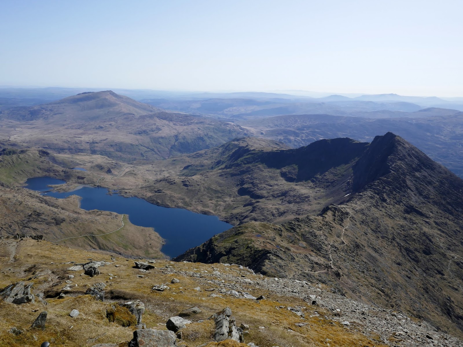
Y Lliwedd, Snowdon, Garnedd Ugain and Crib Goch
Crib Goch - the Pinnacles can clearly be seen to the left
Gallt y Wenallt
While this isn't necessary to complete the horseshoe, Gallt y Wenallt is a Nuttall and a walk out to the summit adds around 2 miles to the horseshoe - if you walk out and back. The grassy ridge is a far cry from the neighbouring mountains and the undulations are quite tiresome. That said, I had the whole ridge and summit to myself.
The Glyders
Gallt y Wenallt
Cwm Dyli
Clouds over Nantygwyrd
I took a well-earned break at Gallt y Wenallt, just as some interesting looking high clouds rolled in. We had been forecast some late evening thunderstorms - perhaps this was them arriving early? As luck would have it the clouds remained interesting and high level before drifting off again, leaving further sun for the final part of the walk.
Gallt y Wenallt's summit
Clouds over the Moelwyns
Moel Siabod
Having read a few descriptions for this addition to the route, I was suitably put off descending directly from Gallt y Wenallt into Cwm Dyli as it is pathless and puts you into some uninviting looking bogs which would spoil a good walk. Instead, it was back up towards Lliwedd Bach to meet the path I had left an hour earlier to descend to the head of Cwm Dyli and join the masses once again on the Miner's Track at Llyn Llydaw.
Llyn Llydaw
The path down to Cwm Dyli
The shores of Llyn Llydaw
Snowdon
Crib Goch
The walk doesn't quite end here as there is still a mile or two of walking to be done, firstly by following the Miner's track to Pen y Pass and then returning down Afon Trawsnant to the Pen y Gwyrd hotel. Looking at the crowds waiting for the bus, I was thankful I had opted against getting the park and ride from Llanberis.
The old barracks at Llyn Teryn
The Miner's Track
Pen y Pass
Nantgwynant
The path at Nant Cynnyd
This is, without a doubt one of the very best mountain days in the country - certainly the best I've ever completed. It has a mix of everything from the edge of your seat drama of Crib Goch to the bustling summit of Snowdon, hands-on excitement and a few moments of contemplative strolling. The views and scenery throughout that day are absolutely epic, from the moment you leave the car to the final few metres of the Miners' Track. This is a proper day out.

2 comments :