Monday, 23 May 2016

The Nantlle Ridge

The Nantlle Ridge 22-05-2016

This map was created using GPS Visualizer's do-it-yourself geographic utilities.

Please wait while the map data loads...


Route: Rhyd-Ddu, Drwsycoed Uchaf, Y Garn, Mynydd Drws-y-coed, Trum y Ddysgl, The Hiatus, Mynydd Tal-y-mignedd, Bwlch Dross-bern. Craig Pennant, Craig Cwm Silyn, Garnedd Goch, Bwlch, Cwmdulyn, Mynydd Graig Goch, Llyn Cwm Dulyn, Nebo

Date: 22/05/2016
From: Rhyd-Ddu


Parking: Roadside in Rhyd-Ddu and Nebo
Start Point: Rhyd-Ddu
Region: Snowdonia

Route length: 8.6 miles (13.8 km)
Time taken: 04:33
Average speed: 1.9 mph
Ascent: 1,053m
Descent: 1,020m

Summits: Y Garn (633m), Mynydd Drws-y-coed (695m), Trum y Ddysgl (709m), Mynydd Tal-y-mignedd (653m), Craig Cwm Silyn (734m), Garnedd Goch (700m), Mynydd Graig Goch (610m)

Other points of interest: The Hiatus, Craig Pennant, Craig Cwm Dulyn

If the prospect of scaling Snowdon on a busy, sunny weekend fills you with dread then cast an eye to the southwest and the modest line of peaks the stretch out westwards from Rhyd-Ddu. At first glance, they may appear inconsequential but a closer inspection reveals lines of crags and the promise of an action-packed day. This line of mountains forms the Nantlle Ridge, one of the finest ridge walks in the country.

Avoiding the possibility of weekend crowds on Wales' highest mountain, we chose to make the most of having two cars by walking the length of the Nantlle Ridge from Rhyd-Ddu to the small village of Nebo. That would involve crossing seven named peaks including the exciting scramble up Clogwyn Marchnad.

We spent a large proportion of the morning shuffling cars around in the rain - it takes time to get from Capel Curig to Nebo and then back to Rhyd-Ddu but this gave the weather time to get its act together and cheer up a bit.
Yr Aran seen as the clouds begin to clear
We set off underneath sullen skies heading for Y Garn, the first peak of the ridge. Leaving Rhyd-Ddu, we followed the B4418 a short distance before joining the bridleway at Drwsycoed Uchaf and heading towards the mountain. Unmarked on the map is a path that makes a direct ascent of Y Garn's eastern slopes. Some drizzly, damp weather drew in as we made the steep, uninspiring climb and by the time we reached the summit the clouds had returned again.
Y Garn seen from the bridleway
Looking across the valley to a cloud-capped Snowdon
The climb up Y Garn is fairly dull
Clouds swirl in as we reach the summit
A cairn is perched right on the cliff edge
Undeterred, we turned south following the wall that leads off Y Garn's summit. As we began a short descent the weather began to look much more favourable, revealing the dramatic crags of Clogwyn Marchnad which form the northern ridge of Mynydd Drws-y-Coed. Ahead is an exciting and sometimes exposed scramble to the summit - easily the best part of the walk.
The view towards the coast opens up
The immense Clogwyn Marchnad
Clogwyn Marchnad - the route follows the edge of the cliffs up to Mynydd Drws-y-coed
The beginning of the scramble
As with much of Wales, the scramble can be as easy or challenging as you want - most of the really exposed bits can be bypassed by a path just off the line of crags. The views down into the valley below are incredible and stretch as far as Caernarfon on the Menai Strait. After the scrambling, Mynydd Drws-y-Coed has an interesting little summit. Two down, five to go.
Looking back to Y Garn
The nose of Clogwyn Matchnad
Mynydd Mawr and Y Garn
Trum y Ddysgl
The scramble continues on
Trum y Ddysgyl
The summit of Mynydd Drws-y-coed
A narrow arete separates Mynydd Drws-y-Coed from the neighbouring Trum y Ddysgl, itself an impressive mountain with an equally impressive view to Mynydd Drws-yCoed. The sun was out in force by now, a stark contrast to the weather earlier in the day.
Trum y Ddysgyl
The crags of Clogwyn Marchnad line Mynydd Drws-y-Coed
Trum y Ddysgl, Mynydd Mawr and Mynydd Drws-y-Coed
Mynydd Drws-y-Coed and the arete leading to Trum y Ddysgl
The summit of Trum y Ddysgyl
An easy grass ridge falls from Trum y Ddysgl towards another narrow arete, this time joining to Mynydd Tal-y-mignedd. This is called The Hiatus thanks to the apparent break right in the middle. This is easily negotiated using a few rocky ledges and another easy grass ridge leads to the obelisk on top of Mynydd Tal-y-mignedd.
Panorama from Trum y Ddysgyl
The Hiatus leading to Mynydd Tal-y-mignedd
Cwm Dwyfor
The Hiatus
The view back to Trum y Ddysgyl
Leading up to Mynydd Tal-y-mignedd
Obelisk on Mynydd Tal-y-mignedd
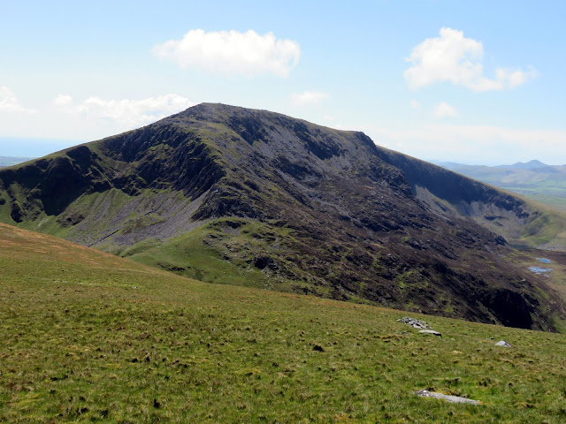
Triangular in shape, Mynydd Tal-y-mignedd throws a ridge southwards, falling gently at first before it steepens into Bwlch Dros-bern. Craig Pennant (the eastern face of Craig Cwm Silyn) paints another impressive picture but means a stiff climb to reach the summit. The path heads southwest a short distance before it doubles back and heads for the rim of the cliffs, which it follows all the way to the top.
Craig Cwm Silyn
Craig Pennant on Craig Cwm Silyn
Mynydd Tal-y-mignedd
Forging a route up Craig Cwm Silyn
Looking down Craig Pennant
Mynydd Tal-y-mignedd with  Trum y Ddysgl in the distance
The view south to Criccieth
Yr Wyddfa makes and appearance - drawing the crowds no doubt
Craig Cwm Silyn's summit
Craig Cwm Silyn is the highest point of the Nantlle Ridge, reaching a height of 734m. It is an impressive mountain, though it is generally overshadowed by its more famous neighbours such as Snowdon and Moel Hebog. The summit cairn was an ancient Bronze Age burial cairn and has been amended to provide shelter from the wind - the views from the crest of this mountain are truly amazing. Though the Nantlle Ridge continues on for a few more miles, Craig Cwm Silyn marks the end of any real significant climbs, the next peak of Garnedd Goch is located across a very shallow depression.
The magnificent view from Craig Cwm Silyn
Garnedd Goch
Tremadog Bay
Garnedd Goch's summit
The summit of Garnedd Goch is one of the few places from which the three castles of Criccieth, Harlech and Caernarfon can be seen. A slow walk off Garnedd Goch is required thanks to the array of boulders that litter the western slopes. It's clear that the popularity of the Nantlle Ridge begins to diminish at this point, there being a distinct lack of paths from here until the end. At Bwlch Cwmdulyn a long but easy climb leads to the final summit of the ridge - Mynydd Graig Goch.
Mynydd Graig Goch
Bwlch Cwmdulyn
Valley leading to Llyn Cwm Dulyn
Mynydd Graig Goch's interesting summit
Garnedd Goch
Mynydd Graig Goch's summit
Mynydd Graig Goch was, until very recently, excluded from many hill lists - chiefly because it fell beneath the magical 610m mark (2,000ft). In 2008 it was resurveyed using state-of-the-art equipment to find that it actually measured 6 inches over 2,000ft and, overnight, the hill became a mountain - Wales' 190th highest in fact.
Penygroes and the Menai Strait
A path concludes the Nantlle Ridge by falling down grass slopes to Llyn Cwm Dulyn, a dammed lake that provides water for this area. The lake is overlooked by Mynydd Graig Goch's most impressive feature; the cliffs and crags of Craig Cwm Dulyn. The lake also marks the end of the Snowdonia National Park, the border of which runs north-east towards the honeypots of Llanberis and Ogwen. Unbeknown to us, you can leave a car at the end of the lake in a small gravel layby - ours was located a mile or so distant in the village of Nebo.
Garnedd Goch over Llyn Cwm Dulyn
Garnedd Coch and Craig Cwm Dulyn
To repeat a number of walking websites, this is a fantastic walk and perhaps one of the best ridge walks in Wales. If you can figure out the logistics of a one-way trip, then that's the best way to see the ridge in full but there are a number of options to see the best parts with a circular walk, the highlight being the scramble up Mynydd Drws-y-coed.

No comments :

Post a Comment