This map was created using GPS Visualizer's do-it-yourself geographic utilities.
Please wait while the map data loads...
Route: Thruscross Reservoir, Six Dales Trail, Redshaw Hall, Burnt House, Spittle Ings House, Rocking Moor, Rocking Hall, Pan Head, Lowcock Stoop, Foulgate Bank
From: Thruscross Reservoir
Parking: Thruscross Reservoir
Start Point: Thruscross Reservoir
Region: Nidderdale AONB
Route length: 7.9 miles (12.7km)
Time taken: 03:40
Average speed: 2.5 mph
Ascent: 346m
Descent: 344m
Summits: None
Other points of interest: Rocking Hall
There are large swaths of North Yorkshire moorland that aren't included in either the Yorkshire Moors or the Yorkshire Dales National Parks. Much of this can be found in the Nidderdale AONB, just east of the Dales park boundary. The weird sculptured stones at Brimham Rocks are arguably the highlight of these parts though our attention was drawn to some of the quiet moorland west of Harrogate.
A string of moors actually straddles the Dales / AONB boundary. These include Stean Moor, Blubberhouses Moor and Pock Stones Moor. You can find the elusive hill of Meugher in these parts. Our plan was to visit Rocking Moor and its lonely shooting lodge.
We parked at Thruscross Reservoir close to its impressive concrete dam. Built in 1966, Thruscross is the topmost and newest reservoir of the Washburn Valley. Often referred to as ‘West End’ after the village it flooded. However, West End was largely derelict anyway as a result of the decline in the flax industry.
 |
| Thruscross Reservoir |
 |
| The Six Dales Trail |
 |
| Thruscross Reservoirs' concrete dam |
 |
| The dam once again |
 |
| The Six Dales Trail |
 | ||
The path to Redshaw Hall
|
 | ||
Kestrel
|
 |
| The distant domes of Menwith Hill |
 |
| Rocking Moor |
 |
| Green Sike on Rocking Moor |
 |
| One of the many grouse on Rocking Moor |
 |
| Rocking Moor |
 |
| Rocking Moor |
 |
| Rocking Hall emerges from the mist |
 |
| Rocking Hall |
 |
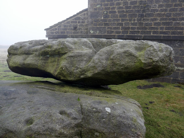
| The rocking stone |
 |
| A close up of the rocking stone |
 |
| An unusual figure above the Rocking Hall doorway |
 |
| Rocking Hall |
 |
| Sara heads out onto the moor |
 |
| Rocking Hall grouse butt |
 |
| The Great Stray |
 |
| Rocking Hall disappears into the mist |
 |
| Looking to Pockstones Moor |
 |
| Bridleway at Fox Holes |
 |
| Boundary stones at Red Gate |
 |
| Whit Moor Road |
 |
| Interesting light over Rocking Moor |
 |
| Snow showers |
 |
| The path to Thruscross Reservoir |
 |
| West End flax mill |
 |
| West End flax mill |
 |
| The flax mill prior to the construction of the reservoir |


No comments :
Post a Comment