The Bochlwyd Horseshoe 20-10-2018
This map was created using GPS Visualizer's do-it-yourself geographic utilities.
Please wait while the map data loads...
Route: Milestone Buttress, Milestone Gully, Tryfan North Ridge, Tryfan, Bwlch Tryfan, Bristly Ridge, Glyder Fach, Castell y Gwynt, Bwlch y Ddwy-Glyder, Y Gribin, Llyn Bochlwyd, Bochlwyd Buttress, A5
Date: 20/10/2018
From: A5 - Milestone Buttress
Parking: Laybys on A5
Start Point: Milestone Buttress
Region: Snowdonia
Route length: 4.2 miles ( km)
Time taken: 07:45
Average speed: 0.9 mph
Ascent: 859m
Descent: 974m
Summits: Tryfan (917m), Glyder Fach (994m), Castell y Gwynt (972m)
Other points of interest: Milestone Gully, The Cannon, Bristly Ridge, The Cantilever, Y Gribin
The Bochlwyd Horseshoe is a full-day adventure; an almost non-stop scramble around the popular Glyderau. It includes all the popular scrambles of the range; Tryfan North Ridge, Tryfan South Ridge, Bristly Ridge and Y Gribin. It also has several of the classic north Wales photo ops; the Cannon, Adam and Eve and the Cantilever. I think it's fair to say this route is rivalled only by the Snowdon Horseshoe. It's been one on my list for a long time.
While the route is very short (around 5 miles) it's a tough day with hands on rock from almost the word go. Today, the only thing that could outshine the route was the weather, as you'll see later on. This was one of those rare mountain days where everything fell into place perfectly.
 |
| Looking across Llyn Ogwen to Y Garn and Foel-goch |
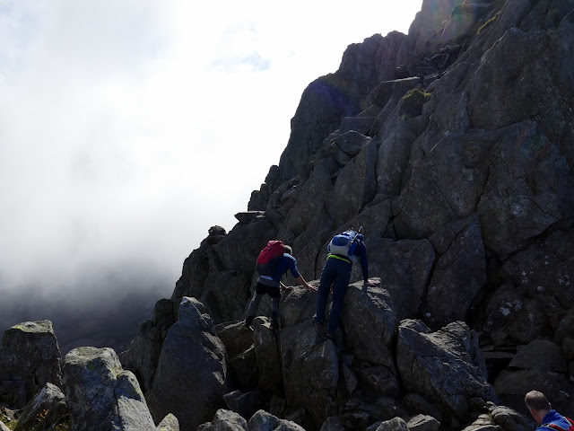
We began from the layby below Tryfan's imposing north ridge. Before us was nearly 600m of almost continuous scrambling to the summit, starting with the Milestone Gully.
 |
| Start as you mean to go on.... |
 |
| Climbing to the base of Milestone Gully |
After following the path a short while we deviated off, over the ladder stile and passing below Milestone Buttress. Milestone Gully Approach is a Grade 1/2 scramble that climbs a gully to the right of the buttress. We all managed to pass the first test, a high shelf at the base (assisted by a modest pile of stone), before making the climb up the gully. Climbing the left side is the easiest line with good hand and footholds throughout. The climb is quite sustained but we eventually emerged unscathed at the top of the buttress.
 |
| Milestone Gully |
 |
| Climbing the gully |
 |
| Emerging at the top of Milestone Gully |
Some modest walking through heather and rocks is required before we tackled a few more entertaining scrambles, including an imposing, craggy wall. As with most routes on Tryfan, they can be made as easy or difficult as you choose and many of the really challenging parts can be easily bypassed. After some more climbing, we found our way to the Cannon.
 |
| More scrambling |
 |
| Y Garn |
 |
| Foel-goch |
 |
| Pen yr Helgi Du and Pen Llithrig y Wrach |
 |
| A peek at The Nose |
 |
| Clouds spilling into Cwm Tryfan |
 |
| The Cannon |
The Cannon is one of the icons of North Wales, a jutting slab of rock, visible from the valley floor which simply begs to be photographed, usually with someone teetering on the end of it.
Section two then, the Cannon to the Nose. This part is generally pretty straightforward and more of a walk than a scramble, though you can seek out the odd hands-on route I'm sure - it's a nice respite for the arms before the stiffer challenges ahead. On a clear day, the Nose will be a clear objective.
 |
| The route up to The Nose |
 |
| Looking down the North Ridge |
 |
| Cwm Tryfan |
 |
| Nant y Benglog |
The Nose is an imposing pyramid of rock that bars the north ridge route. By far the best way is to tackle it head-on. Again, the main routes should be easy to pick out given the amount of polished rock. We opted for a slightly different line to avoid a queue forming though still remained around a scrambling grade of Grade 1 with the odd 2 thrown in for good measure. If you chose to bypass the tower, a path skirts to the left, cutting across the slopes and a number of gullies. I'd highly recommend you attempt to climb the first gully (the upper reaches of Nor Nor gully) to get back up onto the ridge before you find yourself on uncertain ground.
 |
| The Nose |
After the Nose, another flatter section beckons and leads to the North Tower and section 3. The North Tower is as you might expect, a tall tower of rock on the north ridge. The easiest route (which we took) heads to the right of the tower to make some easy scrambling up onto the ridge. The Tower can be attempted directly but the grading here is probably a high 2 and looks technically quite difficult.
 |
| Y Gribin emerges from the cloud |
 |
| On The nose |
 |
| Approaching the North Tower |
 |
| Glyder Fawr |
 |
| Nor Nor Gully |
 |
| The North Tower |
Once up and over (or around) the tower, Tryfan's summit will present itself. After a brief notch in the ridge, the final scramble leads to the summit proper, marked by the two immense monoliths - Adam and Eve. To hop across the 1.2m gap between them is to gain the 'Freedom of Tryfan'.
 |
| Tryfan's summit from the notch |
 |
| The North Tower |
 |
| Clouds over the Gylders |
 |
| Adam and Eve |
The weather was looking immense as we made tracks towards Bristly Ridge where some more quality scrambling awaits. Descending Tryfan's south ridge is easy compared to the scramble up the north and we found our way down to Bwlch Tryfan. Bristly Ridge rises up overhead.
 |
| Glyder Fawr |
 |
| Glyderau panorama from Tryfan |
 |
| Descending Tryfan's south ridge |
 |
| Cwm Bochlwyd |
 |
| Tryfan's south ridge |
 |
| The Glyders from Tryfan South Peak |
 |
| Llyn Bochlywd |
 |
| Bristly Ridge |
 |
| Sinister and Dexter Gully |
There is a choice of gullies to attain Bristly Ridge, Sinister or Dexter. We opted for Dexter Gully on this occasion, the gully to the right (the names stem from Latin; Dexter meaning Right and Sinister meaning Left. This is where you get the description 'ambidextrous' i.e. two right hands). It is steeper than Sinister gully and has more loose material in, making the overall climb trickier though, upon reflection, there's not a great deal of difference between them in terms of scrambling difficulty.
 |
| Pen yr Ole Wen and Tryfan |
 |
| Dexter Gully |
 |
| Climbing Dexter Gully |
 |
| Above Dexter Gully |
 |
| Pen yr Ole Wen |
 |
| Y Foel Goch |
Dexter Gully led us onto Bristly Ridge itself where some easy walking is interspersed with some light scrambling. Don't let this fool you, however, the ridge is only just getting started. After clambering around some smaller pinnacles we reached the Great Pinnacle Gap, a deep notch in the ridge preceding an immense spire of rock. This is the crux of the ridge.
 |
| Bristly Ridge |
 |
| The pinnacles along Bristly Ridge |
Getting to the notch requires a tricky downclimb though, as ever, there are hand and footholds when you search them out. The downclimb leads to a fairly narrow, flat slab which can be lethally slippery when wet. Upon first inspection, the spire of the Great Pinnacle seems to block the onwards route, however, passing around to the right reveals a blocky gully that leads back up to the ridgeline.
 |
| Great Pinnacle gap |
 |
| The route behind the Great Pinnacle |
After tackling the gap a final, steep scramble is required to finish Bristly Ridge. We emerged on the summit of Glyder Fach in brilliant sunshine, the layer of cloud had lifted at just the right time. An hour earlier and we'd have been right in the thick of it. We passed the famed Cantilever; a seemingly precariously balanced slab of rock that simply begs to be photographed, usually with people on it. Glyder Fach's summit is a short distance away but requires some additional scrambling to reach the very top.
 |
| The final obstacle |
 |
| A look back along Bristly Ridge |
 |
| Glyder Fach's summit |
 |
| The Cantilever |
 |
| Glyder Fach's summit |
After clambering round to the other side, a short flat section of the mountaintop leads to the odd Castell y Gwynt - a spiky rock protrusion at the end of the main Glyder Fach ridge. In some circles its classed as one of the Welsh 3,000s, reason enough for another short scramble through the spires to the top.
 |
| Castell y Gwynt and Glyder Fawr |
 |
| Castell y Gwynt |
 |
| Crib Goch and Snowdon |
 |
| Y Gribin with Y Garn beyond |
 |
| Castell y Gwynt |
Higher clouds had started to fill in and a strong, cold wind had begun to blow through the cols and cwms of north Wales. Beyond Castell y Gwynt, the path crosses Bwlch y Ddwy-Glyder, skirts around the head of Cwm Bochlwyd and onto Y Gribin and further scrambling.
 |
| Glyder Fawr across Bwlch y Ddwy-Glyder |
 |
| Cwmffynnon |
 |
| The Snowdon range |
 |
| Descending from Castell y Gwynt |
 |
| Cwm Bochlwyd |
 |
| Y Garn |
 |
| Glyder Fach |
 |
| Starting down Y Gribin |
Y Gribin is a narrow ridge that separates Cwm Bochlwyd and Cwn Cneifion / Cwm Idwal. The crest offers the best line, though a loose path avoids it if necessary. The main scramble doesn't last long, eventually petering out at a broad, flat, grassy area along the ridge - 'the football field'. From here, a path leads down to Nant Bochlwyd, the stream which drains the lake.
 |
| Looking down Cwm Neifion to Cwm Iswal |
 |
| Clouds over Pen yr Ole Wen and Tryfan |
 |
| Y Gribin |
 |
| Y Garn and Llyn Idwal |
 |
| Y Gribin |
 |
| Glyder Fach |
 |
| Y Gribin |
 |
| The pinnacles along Bristly Ridge |
Finally, a brief romp across some boggy ground below Bochlwyd Buttress leads back to the A5 with a short walk along the pavement back to the layby. This is a truly sensational outing, one that will live long in the memory. In my opinion, the scrambling is just the right level of difficulty. Challenging enough to feel a real sense of achievement but not over the top for a typical walker like myself.
 |
| Glyder Fach over Llyn Bochlwyd |
 |
| Pen yr Ole Wen |
 |
| Below Tryfan once again |


No comments :
Post a Comment