Gordale Scar & Malham Cove 15-04-2018
This map was created using GPS Visualizer's do-it-yourself geographic utilities.
Please wait while the map data loads...
Route: Malham, Pennine Way, Mire Barn, New Laithe, Janet's Foss, Gordale Bridge, Gordale Scar, New Close, Street Gate, Water Sinks, Pennine Way, Comb Hill, Watlowes, Malham Cove, Malham
Date: 15/04/2018From: Malham
Parking: Roadside parking in Malham village / National Park Car Park
Start Point: Malham
Region: Yorkshire Dales
Route length: 7.3 miles (11.2 km)
Time taken: 03:07
Average speed: 2.3 mph
Ascent: 382m
Descent: 381m
Points of interest: Janet's Foss, Gordale Scar, Malham Tarn, Ing Scar, Watlowes, Malham Cove
This is perhaps THE classic Yorkshire Dales walk and one that any keen hiker should complete.
This walk starts from Malham, a small village buried in the upper valley of the River Aire. It was originally referred to as Malgun in the Domesday book, a word that means "settlement by the gravelly places". Very apt. After leaving the car on the road (there is plenty of space available if you arrive early enough), we strolled into the village before heading over the river across a small footbridge to join the Pennine Way. The path actually leads south, away from the main attractions.
 |
| Crossing Malham Beck |
 |
| The hill of Cawden |
This misdirection is short-lived though, as the path quickly meets a well-signposted track for Janet's Foss and we spent the next 20 minutes wandering through the glorious fields towards the waterfall and the Malham Estate.
 |
| Heading away from Malham village |
 |
| The Riverside Path |
 |
| A barn stands at the entrance to the woods |
The wooded valley at Janet's Foss Woods is filled with the smell of wild garlic and there is a large felled log, close to the path, that has had several hundred coins pushed into it. A popular theory is that this is a 'wishing tree' and that people would push coins in to make their illnesses disappear. The practice is thought to have started in the 1700s so there could be many very old coins buried in this particular log.
 |
| Janet's Foss Wood |
 |
| Banks of wild garlic |
 |
| Approaching Janet's Foss |
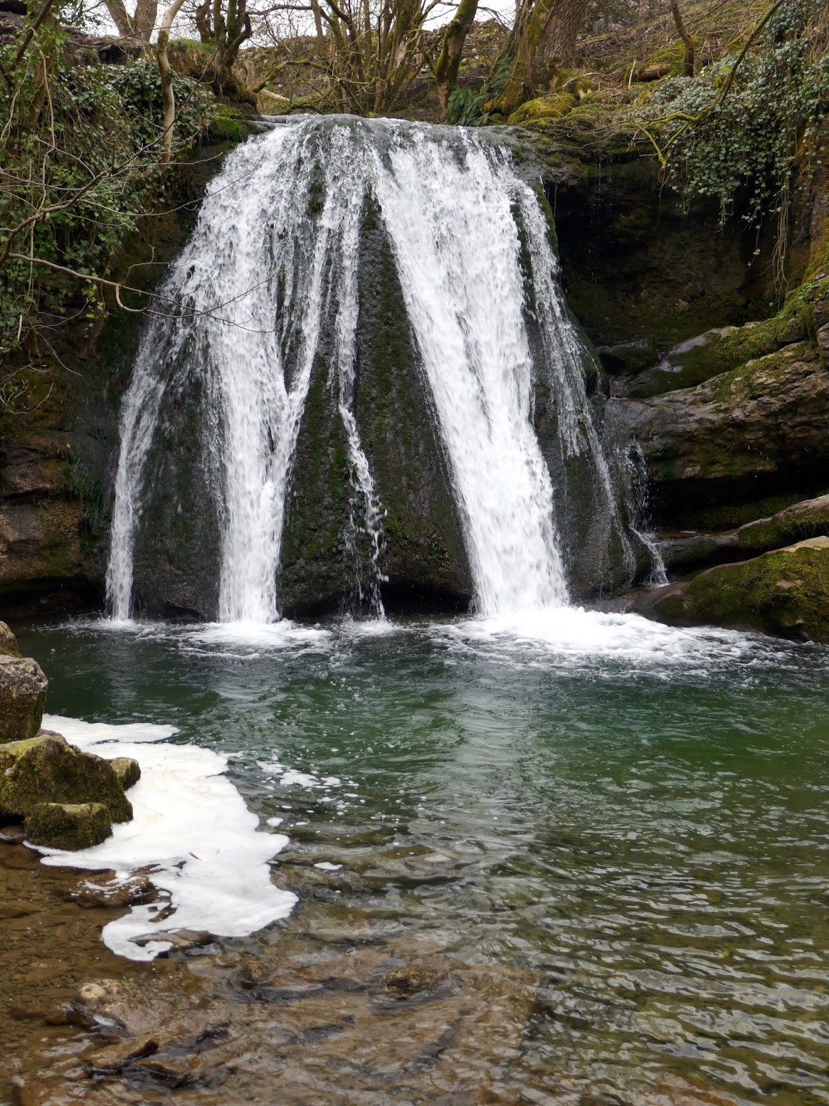
At the end of the wood is the first natural highlight of the day, Janet's Foss, a small waterfall cascading over a limestone outcrop into a stunning turquoise pool, traditionally used for sheep dipping. Janet (or sometimes Jennet) is thought to be a reference to a folktale fairy queen that inhabited the cave at the back of the falls.
 |
| Janet's Foss |
 |
| Janet's Foss |
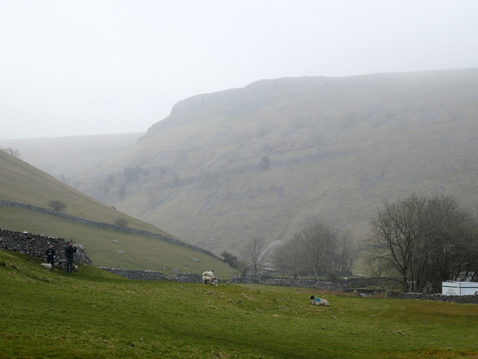
We continued on, climbing out of the valley onto Gordale Lane. Out on the tranquil lane, there is little evidence to suggest the spectacle of Gordale Scar, a mere few hundred metres away.
 |
| New Close Knotts |
 |
| The entrance to Gordale Scar |
Following the path adjacent to Gordale Beck, the valley sides slowly begin to close in. It's not until you reach the very end of the path and round a corner does the full scale of Gordale Scar become apparent.
 |
| Entering Gordale Scar |
 |
| The excitement lies just around the corner |
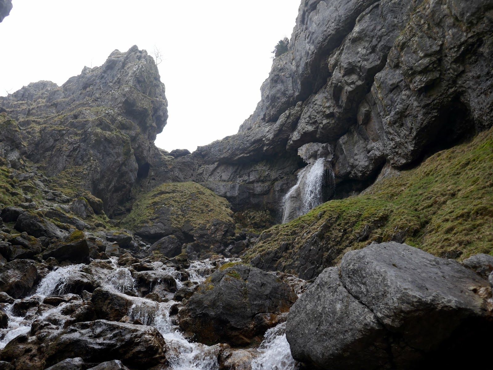
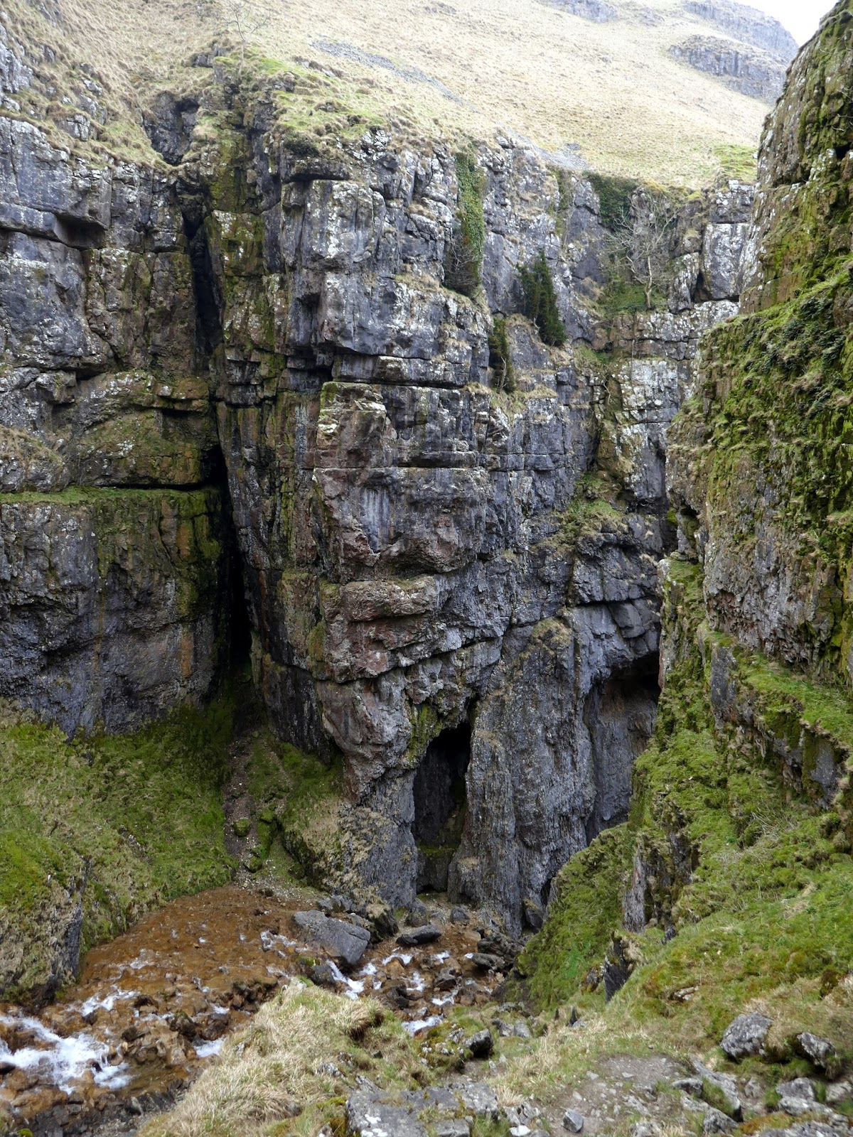
Gordale Scar is the result of the phenomenal power of water, carved out during the last Ice Age. The considerable overhang of the limestone walls also suggests that the ravine was once a cavern, like many others found across the area. Gordale Scar contains two waterfalls, one evident to all visitors at the end of the first valley and a second hidden away in the mid-reaches. It is at this second waterfall that further evidence of the cavern roof can be seen.
 |
| Gordale Scar |
 |
| Gordale Scar |
Climbing Gordale Scar is much easier than it looks but does require a small head for heights. The trickiest part is the first climb up alongside the waterfall that tumbles over the tufa in the valley floor. Upon closer inspection, holes and knots eroded by the water of centuries past provide perfect hand and footholds to haul yourself up into the mid part of the ravine. On busy days there can be quite a wait for your turn to climb but the look of interest and amazement on some peoples faces, those who have decided the climb isn't for them, is worth it as you clamber up and over the seemingly impassable obstacle.
 |
| Sara at the foot of the climb |
 |
| Emerging into the upper reaches |
Once up the first scramble, you will find yourself within the heart of Gordale Scar, with water tumbling past on all sides and the limestone walls still reaching ever skyward. There is also a fine view of the second waterfall, emanating through a large hole in the ravine wall. There is a stepped stone path some way up the middle section, on the left-hand side so aim for that once you are ready to continue on your way. Avoiding wet feet or legs at this point is easier said than done as the slippery rocks and deep pools of water conspire against both you and your very best waterproof boots.
 |
| The second waterfall |
 |
| Sara inspects Gordale's interior |
 |
| The exit |
Climbing the stone staircase brings you up and out of the valley as it continues to carve a swathe through the countryside for a further mile to the north. For the more intrepid explorers, a rocky spit extends back towards Gordale Scar and gives an impressive view down into the ravine. With the excitement of Gordale Scar behind us, we continued along the wide, flat path towards Malham Tarn.
 |
| Looking down into Gordale Scar |
 |
| Gordale Scar from above |
 |
| The path to Malham Tarn |
 |
| Some modest areas of limestone pavement can be found away from the path |
 |
| Looking across to Kirkby Fell |
Interestingly, Malham Tarn is the highest lake in England at 377m, though the definition of the lake needs to be determined as several tarns in the Lake District surpass this altitude. According to the venerable Wikipedia; "One definition of lake is a body of water of 2 hectares (5 acres) or more in area however, others have defined lakes as waterbodies of 5 hectares (12 acres) and above, or 8 hectares (20 acres) and above. Charles Elton, one of the founders of ecology, regarded lakes as waterbodies of 40 hectares (99 acres) or more". Regardless of its size, Malham Tarn is one of only eight upland alkaline lakes in Europe and thus has several special conservation designations.
 |
| Malham Rakes |
 |
| The bulk of Fountains Fell |
 |
| Malham Tarn |
 |
| Malham Tarn |
 |
| The outlet from the tarn |
Away from Malham Tarn, heading south, the route joins the Pennine Way which leads into a deep incision in Comb Hill down to Watlowes. Watlowes is the ancient remnant of the river that was once powerful enough to shape Malham Cove as we see it today. The river that currently flows out of Malham Tarn, though probably the same, no longer possesses the energy for any serious erosion and, in fact, disappears down the imaginatively titled 'Water Sinks' before reappearing some distance downstream of Malham Cove as the source of the River Aire (according to dye testing this river and the one that emanates from the base of Malham Cove are not the same and do not mix in any way).
 |
| Water Sinks |
 |
| The Pennine Way at Comb Hill |
 |
| Watlowes |
 |
| Watlowes |
 |
| Ing Scar |
 |
| Watlowes and Ing Scar |
 |
| Ing Scar |
At the end of the Watlowes dry valley stands the imperious Malham Cove. Originally a colossal waterfall, some 80m high and 300m high, Malham Cove is a natural, curved limestone cliff at the head of the valley of Malham Beck. It rises vertically from the valley floor like a medieval walled fortress and is a popular haunt for rock climbers, walkers and sightseers alike. The curved shape is thanks to the power of the water, eroding the lip at the centre at a greater rate than the edges.
 |
| Malham Cove |
Nowadays, the limestone grikes and extensive cave systems are sufficient enough to prevent a waterfall from forming anytime in the near future. On the subject of grikes, it might be pertinent to mention a bit about the limestones pavement above Malham Cove.
 |
| Malham Cove |
 |
| Malham Cove |
 |
| Malham Cove |
 |
| Malham Cove |
A natural formation, the result of glacial and water erosion, limestone pavement is exactly that, a flat expanse of exposed limestone that resembles an artificial pavement. Cracks in the limestone are eroded by rainfall, limestone being slightly soluble, leading to the formation of a series of limestone blocks, isolated by a network of fissures. These blocks (clints) and the fissures (the grikes) have the appearance of a manmade pavement, hence the name. The Yorkshire Dales has some of the most prominent examples of limestone pavement in the world, particularly above the walls of Malham Cove and around the eastern slopes of Ingleborough, near Clapham.
 |
| The clints and grikes of the limestone pavement |
We spent a few minutes wandering around the limestone pavement before hopping our way over to the path to the west that utilises a set of well-placed steps to carry you down into the valley. Another few minutes were spent wandering around, looking in awe at the sheer size of the limestone rock face and searching in vain for a hidden geocache. In all, we spent a good 45 minutes at Malham before we set off back along the path towards the village and the waiting car.
 |
| Malham Cove |
 |
| Malham Cove |
As a geographer, any walk is exciting but this one is right up there at the top. We're fortunate to have some of the foremost limestone scenery in the world and I'm lucky enough to be able to visit it almost at will. For such a short walk, this really does pack a punch and has something for everyone. A fantastic scramble up Gordale Scar, an amble around Malham Tarn and the jaw-dropping Malham Cove. You could spend a day exploring each small section, they're that good but join them up into a full circuit and you have one of the very best walks in the Dales.


Today (May 24, 2026) we hiked your route. Your map and guide comments were awesome and appreciated. One person on our hike didn't want to walk up the Gordell Scar waterfall, so we hiked up to the bottom of the waterfall and then back down the trail to the 1st right turn. There is a steep trail up (as you mention) that has an amazing view of the valley out of the scar. Its worth doing the hike this way if anyone is suspicious of a slippery waterfall hike. On Strava this route was 8.9miles.
ReplyDeleteThank you so much!
Thanks Mark! I'm glad you and your entire gang safely negotiated Gordale - it's easily one of the best hikes in the area. Happy hiking!
Delete