
This map was created using GPS Visualizer's do-it-yourself geographic utilities.
Please wait while the map data loads...
Route: Llanberis, Bwlch-y-groes, Bryn Mawr, Moel Eilio, Bwlch Cwm Caseg, Foel Gron, Foel Goch, Bwlch Maesgwm, Moel Cynghorion, Bwlch Cwm Brwynog, Snowdon Ranger Path, Clogwyn Du'r Arddu, Bwlch Glas, Snowdon, Bwlch Glas, Garnedd Ugain, Gryn Las, Clogwyn Station, Llechog, Tryfan, Llanberis Path, Llanberis
From: Llanberis
Parking: Llanberis
Start Point: Pete's Eats, Llanberis
Region: Snowdonia - Snowdon
Route length: 14.1 miles (22.7 km)
Time taken: 06:36
Average speed: 2.1 mph
Ascent: 1,752m
Descent: 1,774m
Summits: Moel Eilio (726m), Foel Gron (629m), Moel Cynghorion (674m), Yr Wyddfa (Snowdon) (1,085m), Garnedd Ugain (1,065m), Llechog (718m)
Other points of interest: Cwm Dwyhtwch, Snowdon Ranger Path, Hafod Eryri, Clogwyn Station
This long route to Snowdon is one I've had in mind for a few months now; I nearly did it instead of the Cwm Eigiau Horseshoe I completed a few weeks ago. This walk joins a number of outings into one continuous route and includes a large proportion of the Moel Eilio Horseshoe, the main section of the Snowdon Ranger Path and an easy descent down the Llanberis Path. It promised to be a great day.
We deliberately delayed our start time until late morning, not planning on arriving at Snowdon until early evening. While Snowdon is a great mountain, it can be crowded on a summer day so we were anticipating it being a little less busy by the time we arrived which would also, hopefully, coincide with some brighter weather - the threat of showers would accompany us for much of the day.
Starting in Llanberis, we made our way along Goodman Street to reach Ffordd Clegir and the old slate quarries to the west of the town. A signposted path wends up through the spoil heaps to Bwlch-y-groes and the bottom of Moel Eilio's north ridge.
 |
| Woodland above Llanberis |
 |
| Elidir Fawr behind the slate spoil |
 |
| More slate spoil approaching Bwlch-y-groes |
 |
| Mountains surrounding the Llanberis Pass |
 |
| A large shower over Penygroes |
 |
| Grey skies over Llanberis |
 |
| The line up Moel Eilio |
 |
| Showers begin to clear |
 |
| Llanberis and Elidir Fawr |
 |
| A superfluous stile |
 |
| Approaching the summit |
 |
| Caernarfon Castle from Moel Eilio |
 |
| Moel Eilio's summit shelter |
 |
| Cwm yr Hafod |
 |
| The Menai Strait |
 |
| The Moel Eilio ridge |
 |
| Moel Eilio from Bwlch Cwm Cesig |
 |
| Cwm yr Hafod and Llyn Dwythwch |
 |
| Cwm Cesig looking to Foel Gron |
 |
| Moel Eilio over Bwlch Cwm Cesig |
 |
| The dramatic Nantlle ridge |
 |
| Foel Gron and Foel Goch |
 |
| Cwm Cesig |
 |
| Llyn Cwellyn |
 |
| Foel Gron |
 |
| Foel Goch |
 |
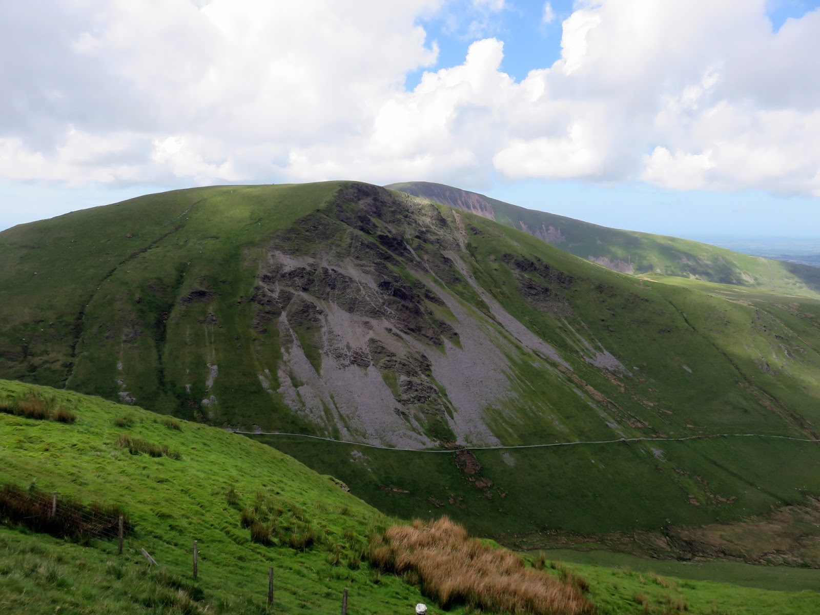
| Foel Gron and Moel Eilio |
 |
| Moel Eilio |
 |
| Looking along Maesgwm |
 |
| Moel Cynghorion |
 |
| The path leading along Bwlch Carreg y Gigfran |
 |
| Foel Goch above Maesgwm |
 |
| Llechog and Cwm Clogwyn |
 |
| Panorama from Moel Cynghorion |
 |
| Snowdon |
 |
| The Snowdon Ranger Path |
 |
| The summit ridge of Moel Cynghorion |
 |
| Moel Cynghorion's summit |
 |
| Clogwyn Du'r Arddu |
 |
| Bwlch Cwm Brwynog below Clogwyn Du'r Arddu |
 |
| Llyn Ffynnon-y-gwas |
 |
| Cwm Clogwyn and Llechog |
 |
| Llechog |
 |
| Ffynnon-y-gwas |
 |
| Clogwyn Du'r Arddu |
 |
| Snowdon's summit |
 |
| Moel Cynghorion |
 |
| The Snowdon Ranger path |
 |
| The path as the gradient starts to ease |
 |
| Looking down into Cwm Clogwyn |
 |
| The Nantlle Ridge and Mynydd Mawr |
 |
| Snowdon's summit |
 |
| Looking down the Snowdon Ranger Path |
 |
| Snowdon from Bwlch Glas |
 |
| The famous Snowdon Mountain Railway |
 |
| Snowdon's summit |
 |
| Another empty summit photo |
 |
| Yours truly |
 |
| Crib Goch, Llyn Llydaw and Y Lliwedd seen from the summit |
 |
| Y Lliwedd and the Watkin Path |
 |
| Crib Goch |
 |
| Moel Siabod plays havoc with the exposure |
 |
| The Pyg and Miners' Tracks meet above Glaslyn |
 |
| The Snowdon Mountain Railway climbs to the summit |
 |
| The Pyg Track at Blwch Glas |
 |
| Garnedd Ugain |
 |
| Snowdon and Y Lliwedd |
 |
| Y Lliwedd |
 |
| Garnedd Ugain's trig pillar |
 |
| A glimpse down Cwm Glas to the Llanberis Pass |
 |
| Clogwyn Station and Llechog |
 |
| Cwm Uchaf |
 |
| Crib Goch |
 |
| Llechog and the Llanberis Pass |
 |
| Glyder Fawr |
 |
| The Mountain Railway |
 |
| Sun over the Moel Eilio ridge |
 |
| Clogwyn Station |
 |
| Y Garn and Glyder Fawr |
 |
| Llechog |
 |
| Moel Cynghorion and Moel Eilio |
 |
| Llechog's unmarked summit |
 |
| The Llanberis Pass |
 |
| The ridge route to Llanberis |
 |
| Glyder Fawr |
 |
| Moel Cynghorion |
 |
| The Llanberis Pass |
 |
| Clouds still covered Snowdon |
 |
| Moel Cynghorion |
 |
| Two of Tryfan's three peaks |
 |
| Llanberis and Llyn Padarn |
 |
| Elidir Fawr |
Climbing Snowdon is always exciting and this long route is no exception, combining the excellent Moel Eilio horseshoe and the Snowdon Ranger Path to create an awesome mountain day out.
That was a truly memorable walk. Bit of an epic too.
ReplyDeleteSkip